
Dane County topographic map
Interactive map
Click on the map to display elevation.
Dane County
Dane County showcases a diverse topography characterized by its rolling hills and numerous lakes, primarily shaped by glacial activity during the last Ice Age. The terrain varies significantly, with elevations ranging from approximately 860 feet to 1,200 feet above sea level. The county is famously known for the Yahara River chain of lakes, which includes Lakes Mendota, Monona, Waubesa, and Kegonsa, forming an "isthmus" in Madison. This river system, combined with the surrounding hills, creates a picturesque landscape that is both scenic and ecologically rich. In addition to the lakes, the county features numerous parks and natural areas that highlight its topographical variety, including woodlands and prairies, contributing to the region's biodiversity and recreational opportunities.
About this map
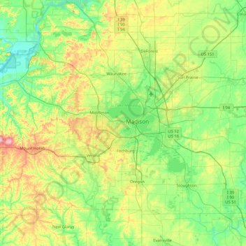
Name: Dane County topographic map, elevation, terrain.
Location: Dane County, Wisconsin, United States (42.84515 -89.83857 43.29416 -89.00883)
Average elevation: 948 ft
Minimum elevation: 715 ft
Maximum elevation: 1,565 ft
Wisconsin trails, hiking, mountain biking, running and outdoor activities
Other topographic maps
Click on a map to view its topography, its elevation and its terrain.
Danbury
United States > Wisconsin > Burnett County > Town of Swiss
Danbury is located at 46.006N. The longitude is -92.371W. It is in the Central Standard Time Zone. The elevation is 938 feet (286 m) above sea level.
Average elevation: 942 ft
Rib Mountain State Park
United States > Wisconsin > Marathon County > Wausau
Average elevation: 1,332 ft
Wildcat Mountain State Park
United States > Wisconsin > Vernon County > Town of Whitestown
Average elevation: 1,017 ft
Liberty Creek State Wildlife Area
United States > Wisconsin > Green County > Town of Albany
Average elevation: 863 ft
George W Mead State Wildlife Management Area
United States > Wisconsin > Marathon County > Town of Bergen
Average elevation: 1,125 ft
Aztalan State Park
United States > Wisconsin > Jefferson County > Town of Aztalan
Average elevation: 837 ft
Wildcat Mountain State Park
United States > Wisconsin > Vernon County > Town of Whitestown
Average elevation: 1,017 ft
Deansville Wildlife Area
United States > Wisconsin > Dane County > Town of York
Average elevation: 866 ft
Long Slide Falls County Park
United States > Wisconsin > Marinette County > Town of Niagra
Average elevation: 945 ft
Governor Dodge State Park
United States > Wisconsin > Iowa County > Town of Dodgeville
Average elevation: 1,102 ft
Tower Hill State Park
United States > Wisconsin > Iowa County > Spring Green
Average elevation: 764 ft
Larry Forrest Park
United States > Wisconsin > Saint Croix County > Somerset
Average elevation: 906 ft
Walking Iron County Park
United States > Wisconsin > Dane County > Town of Mazomanie
Average elevation: 774 ft
North Clayton
United States > Wisconsin > Crawford County > Town of Clayton
Average elevation: 1,093 ft
Rib Mountain State Park
United States > Wisconsin > Marathon County > Wausau
Average elevation: 1,332 ft
Sheboygan Marsh 2 WP 319 Dam
United States > Wisconsin > Sheboygan County > Town of Russell
Average elevation: 932 ft
Observatory Hill State Natural Area
United States > Wisconsin > Marquette County
Average elevation: 860 ft
McAllister
United States > Wisconsin > Marinette County
McAllister is located at the intersection of Wisconsin Highway 180 and County Highway JJ 11.5 miles (18.5 km) east-southeast of Wausaukee at an elevation of 692 feet (211 m). It is connected by road to Wausaukee to the west, Packard to the north, Wagner to the south, and Wallace, Michigan, to the east via a…
Average elevation: 689 ft
Wilderness Lake
United States > Wisconsin > Bayfield County > Town of Drummond
Average elevation: 1,283 ft
Milwaukee River Floodplain Forest State Natural Area
United States > Wisconsin > Washington County
Average elevation: 955 ft
Marinette County Beech Forest State Natural Area
United States > Wisconsin > Marinette County
Average elevation: 1,217 ft
Isthmus Path Prairie Garden
United States > Wisconsin > Dane County > Madison
Average elevation: 860 ft
Yellowstone Lake State Park
United States > Wisconsin > Lafayette County > Blanchardville > Town of Fayette
Average elevation: 945 ft
Lake Adelade
United States > Wisconsin > Vilas County > Town of Winchester
Average elevation: 1,667 ft
Village of West Salem
United States > Wisconsin > La Crosse County > West Salem
Average elevation: 741 ft