
Make a donation
Gear up for your next adventure:
As an Amazon Associate, this site earns from qualifying purchases at no extra cost to you.
Lake Ontario topographic map
Click on the map to display elevation.
Gear up for your next adventure:
As an Amazon Associate, this site earns from qualifying purchases at no extra cost to you.
Lake Ontario
Lake Ontario is the easternmost of the Great Lakes and the smallest in surface area (7,340 sq mi, 18,960 km2), although it exceeds Lake Erie in volume (393 cu mi, 1,639 km3). It is the 13th largest lake in the world. When its islands are included, the lake's shoreline is 712 miles (1,146 km) long. As the last lake in the Great Lakes' hydrologic chain, Lake Ontario has the lowest mean surface elevation of the lakes at 243 feet (74 m) above sea level; 326 feet (99 m) lower than its neighbor upstream. Its maximum length is 193 statute miles (311 kilometres; 168 nautical miles), and its maximum width is 53 statute miles (85 km; 46 nmi). The lake's average depth is 47 fathoms 1 foot (283 ft; 86 m), with a maximum depth of 133 fathoms 4 feet (802 ft; 244 m). The lake's primary source is the Niagara River, draining Lake Erie, with the Saint Lawrence River serving as the outlet. The drainage basin covers 24,720 square miles (64,030 km2). As with all the Great Lakes, water levels change both within the year (owing to seasonal changes in water input) and among years (owing to longer-term trends in precipitation). These water level fluctuations are an integral part of lake ecology and produce and maintain extensive wetlands. The lake also has an important freshwater fishery, although it has been negatively affected by factors including overfishing, water pollution and invasive species.
Make a donation
Gear up for your next adventure:
As an Amazon Associate, this site earns from qualifying purchases at no extra cost to you.
About this map
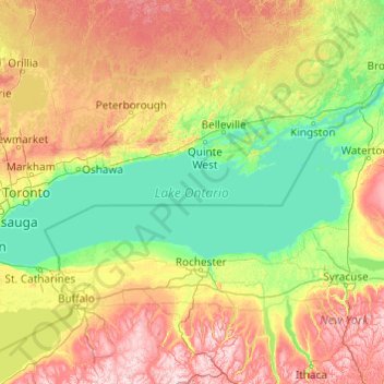
Name: Lake Ontario topographic map, elevation, terrain.
Location: Lake Ontario, Ontario, Canada (43.15936 -79.92529 44.29337 -76.04535)
Average elevation: 702 ft
Minimum elevation: 230 ft
Maximum elevation: 2,293 ft
Make a donation
Gear up for your next adventure:
As an Amazon Associate, this site earns from qualifying purchases at no extra cost to you.
Other topographic maps
Click on a map to view its topography, its elevation and its terrain.
Toronto
Despite its deep ravines, Toronto is not remarkably hilly, but its elevation does increase steadily away from the lake. Elevation differences range from 76.5 metres (251 ft) above sea level at the Lake Ontario shore to 209 m (686 ft) ASL near the York University grounds in the city's north end at the…
Average elevation: 371 ft
Make a donation
Gear up for your next adventure:
As an Amazon Associate, this site earns from qualifying purchases at no extra cost to you.
Slate Islands
Canada > Ontario > Kenora District > Unorganized Kenora District
Average elevation: 1,056 ft
Make a donation
Gear up for your next adventure:
As an Amazon Associate, this site earns from qualifying purchases at no extra cost to you.
Manitouwadge
Canada > Ontario > Thunder Bay District > Manitouwadge Township
Average elevation: 1,184 ft
Pittston
Canada > Ontario > Leeds and Grenville Counties > Edwardsburgh/Cardinal
Average elevation: 269 ft
Make a donation
Gear up for your next adventure:
As an Amazon Associate, this site earns from qualifying purchases at no extra cost to you.
Ellery Lake
Canada > Ontario > Cochrane District > Unorganized North Cochrane
Average elevation: 1,148 ft
Echo Lake
Canada > Ontario > Timiskaming District > Unorganized West Timiskaming
Average elevation: 1,112 ft
Make a donation
Gear up for your next adventure:
As an Amazon Associate, this site earns from qualifying purchases at no extra cost to you.
Make a donation
Gear up for your next adventure:
As an Amazon Associate, this site earns from qualifying purchases at no extra cost to you.
Morewood
Canada > Ontario > Stormont, Dundas and Glengarry Counties > North Dundas
Average elevation: 253 ft
Fauquier
Canada > Ontario > Cochrane District > Fauquier-Strickland Township
Average elevation: 738 ft
Alligator Point
Canada > Ontario > Algoma District > Unorganized North Algoma
Average elevation: 1,047 ft
Make a donation
Gear up for your next adventure:
As an Amazon Associate, this site earns from qualifying purchases at no extra cost to you.
Sesekinika
Canada > Ontario > Timiskaming District > Unorganized West Timiskaming
Average elevation: 1,050 ft
Galbraith Lake
Canada > Ontario > Kenora District > Unorganized Kenora District
Average elevation: 1,493 ft
Make a donation
Gear up for your next adventure:
As an Amazon Associate, this site earns from qualifying purchases at no extra cost to you.
Make a donation
Gear up for your next adventure:
As an Amazon Associate, this site earns from qualifying purchases at no extra cost to you.
La Cloche Mountains
Canada > Ontario > Sudbury District > Sables-Spanish Rivers Township
Average elevation: 1,106 ft
Cedar Island
Canada > Ontario > Algoma District > Plummer Additional Township
Average elevation: 709 ft
Opeongo Lake Dam
Canada > Ontario > Nipissing District > Unorganized South Nipissing
Average elevation: 1,375 ft
Make a donation
Gear up for your next adventure:
As an Amazon Associate, this site earns from qualifying purchases at no extra cost to you.
Quadeville
Canada > Ontario > Renfrew County > Brudenell, Lyndoch and Raglan
Average elevation: 1,093 ft
Berwick
Canada > Ontario > Stormont, Dundas and Glengarry Counties > North Stormont
Average elevation: 246 ft
Make a donation
Gear up for your next adventure:
As an Amazon Associate, this site earns from qualifying purchases at no extra cost to you.
Make a donation
Gear up for your next adventure:
As an Amazon Associate, this site earns from qualifying purchases at no extra cost to you.
Make a donation
Gear up for your next adventure:
As an Amazon Associate, this site earns from qualifying purchases at no extra cost to you.
Loveland Lake
Canada > Ontario > Kenora District > Unorganized Kenora District
Average elevation: 1,398 ft
Hubbard Creek
Canada > Ontario > Sudbury District > Unorganized North Sudbury
Average elevation: 1,499 ft
Ellsmere Island
Canada > Ontario > Parry Sound District > The Archipelago Township
Average elevation: 646 ft
Make a donation
Gear up for your next adventure:
As an Amazon Associate, this site earns from qualifying purchases at no extra cost to you.
Kellow Lake
Canada > Ontario > Thunder Bay District > Unorganized Thunder Bay District
Average elevation: 965 ft
Make a donation
Gear up for your next adventure:
As an Amazon Associate, this site earns from qualifying purchases at no extra cost to you.
Apple Hill
Canada > Ontario > Stormont, Dundas and Glengarry Counties > North Glengarry
Average elevation: 295 ft
Make a donation
Gear up for your next adventure:
As an Amazon Associate, this site earns from qualifying purchases at no extra cost to you.
Cockburn Island
Canada > Ontario > Leeds and Grenville Counties > Elizabethtown-Kitley
Average elevation: 367 ft
Make a donation
Gear up for your next adventure:
As an Amazon Associate, this site earns from qualifying purchases at no extra cost to you.
Make a donation
Gear up for your next adventure:
As an Amazon Associate, this site earns from qualifying purchases at no extra cost to you.
Iroquois
Canada > Ontario > Stormont, Dundas and Glengarry Counties > South Dundas
Average elevation: 272 ft
Make a donation
Gear up for your next adventure:
As an Amazon Associate, this site earns from qualifying purchases at no extra cost to you.
St. Helena Island
Canada > Ontario > Leeds and Grenville Counties > Front of Yonge
Average elevation: 377 ft
Edison Lake
Canada > Ontario > Kenora District > Unorganized Kenora District
Average elevation: 1,263 ft
Make a donation
Gear up for your next adventure:
As an Amazon Associate, this site earns from qualifying purchases at no extra cost to you.
Make a donation
Gear up for your next adventure:
As an Amazon Associate, this site earns from qualifying purchases at no extra cost to you.