Geolocate

Gordon County topographic map

Interactive map

Click on the map to display elevation.

About this map

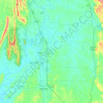
Name: Gordon County topographic map, elevation, terrain.

Location: Gordon County, Georgia, United States (34.38419 -85.11233 34.63070 -84.64449)

Average elevation: 801 ft

Minimum elevation: 581 ft

Maximum elevation: 2,073 ft

Georgia trails, hiking, mountain biking, running and outdoor activities

Other topographic maps

Click on a map to view its topography, its elevation and its terrain.

Stone Mountain

United States > Georgia > DeKalb County

The park is owned by the state of Georgia and is currently managed by Herschend Family Entertainment. At its summit, the elevation is 1,686 feet (514 m) above sea level and 825 feet (251 m) above the surrounding area. Stone Mountain is well known for not only its geology, but also the enormous rock relief on…

Average elevation: 981 ft

Forge Mill

United States > Georgia > Fannin County

Average elevation: 1,762 ft

Mount Rachel

United States > Georgia > Whitfield County > Dalton

Average elevation: 755 ft

St. Simons

United States > Georgia > Glynn County

Average elevation: 7 ft

Beasley Gap

United States > Georgia > Cherokee County

Average elevation: 1,280 ft

Silver Hill

United States > Georgia > Chattooga County

Average elevation: 869 ft

Whispering Pines

United States > Georgia > Bibb County > Macon

Average elevation: 433 ft

Whitesville

United States > Georgia > Harris County

Average elevation: 679 ft

Shellman Bluff

United States > Georgia > McIntosh County

Average elevation: 16 ft

Bell Knob

United States > Georgia > Towns County

Average elevation: 2,379 ft

Georgia Island

United States > Georgia > Hall County

Average elevation: 1,089 ft

Waterloo

United States > Georgia > Irwin County

Average elevation: 331 ft

Driskolls

United States > Georgia > Carroll County > Villa Rica

Average elevation: 1,099 ft

Beverly Heights

United States > Georgia > Richmond County > Augusta

Average elevation: 289 ft

Sargent

United States > Georgia > Coweta County

Average elevation: 810 ft

Dowdell Knob

United States > Georgia > Harris County

Average elevation: 1,056 ft

Bowden

United States > Georgia > Henry County

Average elevation: 830 ft

Seabrook

United States > Georgia > Liberty County

Average elevation: 23 ft

Newnan Pines

United States > Georgia > Coweta County

Average elevation: 912 ft

Dorchester

United States > Georgia > Richmond County > Augusta

Average elevation: 295 ft

Old Clyattville

United States > Georgia > Lowndes County

Average elevation: 190 ft

Settles Bridge

United States > Georgia > Gwinnett County > Suwanee

Average elevation: 1,030 ft

Moncrief

United States > Georgia > Grady County

Average elevation: 217 ft

Salem

United States > Georgia > Richmond County > Augusta

Average elevation: 299 ft

Chula

United States > Georgia > Tift County

Average elevation: 361 ft

Pleasant Hill

United States > Georgia > Fannin County

Average elevation: 1,795 ft

Mauk

United States > Georgia > Taylor County

Average elevation: 719 ft

Rabun Gap

United States > Georgia > Rabun County

Average elevation: 2,241 ft

Elko

United States > Georgia > Houston County

Average elevation: 404 ft

McCullough

United States > Georgia > Fannin County

Average elevation: 1,834 ft

Shoal Creek

United States > Georgia > Clarke County > Athens

Average elevation: 738 ft

Blowing Spring

United States > Georgia > Walker County

Average elevation: 1,063 ft

Blood Mountain

United States > Georgia > Union County

Blood Mountain is the highest peak on the Georgia section of the Appalachian Trail and the sixth-tallest mountain in Georgia, with an elevation of 4,458 feet (1,359 m). It is located on the border of Lumpkin County with Union County and is within the boundaries of the Chattahoochee National Forest and the…

Average elevation: 3,438 ft

Springlake Estates

United States > Georgia > Gwinnett County > Buford

Average elevation: 1,158 ft

Dawson Heights

United States > Georgia > Dougherty County > Albany

Average elevation: 236 ft

Bobo

United States > Georgia > Gordon County

Average elevation: 912 ft

Union

United States > Georgia > Henry County

Average elevation: 705 ft

Strickland Heights

United States > Georgia > Hall County

Average elevation: 1,066 ft

St. Simons

United States > Georgia > Glynn County

Average elevation: 7 ft

Texas

United States > Georgia > Heard County

Average elevation: 846 ft

Lake Lure Dam

United States > Georgia > Bacon County > Alma

Average elevation: 194 ft

Villanow

United States > Georgia > Walker County

Average elevation: 925 ft

Brook Run Park

United States > Georgia > DeKalb County > Dunwoody

Average elevation: 1,001 ft

Mountain Park

United States > Georgia > Gwinnett County

Average elevation: 958 ft

Box Springs

United States > Georgia > Talbot County

Average elevation: 407 ft

Saint Simons

United States > Georgia > Glynn County

Average elevation: 7 ft

Lake Joy

United States > Georgia > Houston County

Average elevation: 344 ft

Marble Hill

United States > Georgia > Pickens County

Average elevation: 1,325 ft

Mountville

United States > Georgia > Troup County

Average elevation: 866 ft

Shadowlawn

United States > Georgia > Camden County > St. Marys

Average elevation: 10 ft

Mableton

United States > Georgia > Cobb County

Average elevation: 978 ft

Frontier Trail

United States > Georgia > Hall County

Average elevation: 1,043 ft

Ash

United States > Georgia > Paulding County

Average elevation: 1,047 ft

Westwood

United States > Georgia > Dougherty County > Albany

Average elevation: 223 ft

Ellenton

United States > Georgia > Colquitt County

Average elevation: 253 ft

Weaver Lake

United States > Georgia > Rockdale County > Conyers

Average elevation: 771 ft

Windsor Court

United States > Georgia > Richmond County > Augusta

Average elevation: 217 ft

Manor

United States > Georgia > Ware County

Average elevation: 154 ft

Univeter

United States > Georgia > Cherokee County > Canton

Average elevation: 1,076 ft

Matt

United States > Georgia > Forsyth County

Average elevation: 1,158 ft

Sunnydale Acres

United States > Georgia > Bibb County > Macon

Average elevation: 371 ft

Lake Ranch

United States > Georgia > Hall County

Average elevation: 1,155 ft

Ashland

United States > Georgia > Franklin County

Average elevation: 774 ft

Dougherty Lake Dam

United States > Georgia > Bibb County > Macon

Average elevation: 466 ft

Bonaire

United States > Georgia > Houston County

Average elevation: 328 ft

Clyo

United States > Georgia > Effingham County

Average elevation: 79 ft

Dorsey

United States > Georgia > Morgan County

Average elevation: 653 ft

Lasater Lake

United States > Georgia > Troup County

Average elevation: 820 ft

Bald Mountain

United States > Georgia > Murray County

Average elevation: 3,235 ft

Trion

United States > Georgia > Chattooga County

Average elevation: 715 ft

Epworth

United States > Georgia > Fannin County

Average elevation: 1,719 ft

Toccoa Falls

United States > Georgia > Stephens County > Toccoa

Average elevation: 1,099 ft

Mineral Bluff

United States > Georgia > Fannin County

Average elevation: 1,693 ft

Henrico

United States > Georgia > DeKalb County

Average elevation: 883 ft

Lanier Island

United States > Georgia > Glynn County

Average elevation: 10 ft

Terrace Manor

United States > Georgia > Richmond County > Augusta

Average elevation: 328 ft

Bay

United States > Georgia > Colquitt County

Average elevation: 308 ft

Monks Crossing

United States > Georgia > Lowndes County

Average elevation: 187 ft

Louise Lake

United States > Georgia > Spalding County

Average elevation: 883 ft

Corbin

United States > Georgia > Bartow County

Average elevation: 1,010 ft

Cisco

United States > Georgia > Murray County

Average elevation: 961 ft

Shandra Estates

United States > Georgia > Fulton County

Average elevation: 948 ft

Wilscot

United States > Georgia > Fannin County

Average elevation: 2,014 ft

Norman Park

United States > Georgia > Colquitt County

Average elevation: 328 ft

Suches

United States > Georgia > Union County

Average elevation: 2,858 ft

Yellow Dirt

United States > Georgia > Heard County

Average elevation: 778 ft

Augusta Canal

United States > Georgia > Richmond County > Augusta

Average elevation: 262 ft

Dial

United States > Georgia > Fannin County

Average elevation: 2,008 ft

Kentucky Island

United States > Georgia > Wayne County

Average elevation: 62 ft

Piedmont Park

United States > Georgia > Fulton County > Atlanta

Average elevation: 928 ft

Aboretum

United States > Georgia > Cobb County

Average elevation: 1,047 ft

Shake Rag

United States > Georgia > Fulton County > Johns Creek

Average elevation: 984 ft