LaPorte County topographic map
Interactive map
Click on the map to display elevation.
About this map
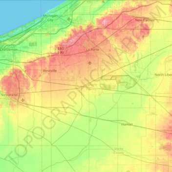
Name: LaPorte County topographic map, elevation, terrain.
Location: LaPorte County, Indiana, United States (41.23680 -86.93416 41.76104 -86.48617)
Average elevation: 719 ft
Minimum elevation: 574 ft
Maximum elevation: 951 ft
Other topographic maps
Click on a map to view its topography, its elevation and its terrain.
West Lafayette
United States > Indiana > Tippecanoe County
West Lafayette lies in central Tippecanoe County and overlooks the Wabash River, which borders the city on the east and south. Most of the city lies in eastern Wabash Township, though a small portion on the northeast side extends into Tippecanoe Township. Elevations range from slightly over 500 feet (150 m)…
Average elevation: 630 ft
South Bend
United States > Indiana > Saint Joseph County
On September 29, 1929, South Bend completed its "track elevation program". This was a railroad infrastructure project which saw the removal of Grand Trunk Western Railroad tracks from Division Street, the removal of level crossings from Chapin to Miami streets, the creation of a modern freight layout, and the…
Average elevation: 774 ft
Fort Wayne
United States > Indiana > Allen County
The first settlement started in 1815. In 1819, the military garrison abandoned the fort and moved to Detroit. In 1822, a federal land office opened to sell land ceded by local Native Americans by the Treaty of St. Mary's in 1818. Platted in 1823 at the Ewing Tavern, the village became an important frontier…
Average elevation: 807 ft
Lafayette
United States > Indiana > Tippecanoe County
Lafayette is located at 40°24′38″N 86°52′29″W / 40.410585°N 86.874681°W / 40.410585; -86.874681 (40.410585, −86.874681) and is located in Fairfield and Wea Townships. Elevation at the court house is 550 feet (168 m), but city elevations range from a little over 500 feet (150 m) at the…
Average elevation: 630 ft
Indianapolis
United States > Indiana > Indianapolis
Indianapolis is within the Tipton Till Plain, a flat to gently sloping terrain underlain by glacial deposits known as till. The lowest point in the city is about 650 feet (198 m) above mean sea level, with the highest natural elevation at about 900 feet (274 m) above sea level. Few hills or short ridges, known…
Average elevation: 791 ft
Bloomington
United States > Indiana > Monroe County
Bloomington is an area of irregular limestone terrain characterized by sinks, ravines, fissures, underground streams, sinking streams, springs and caves. It is in the rolling hills of southern Indiana, resting on the intersection of the Norman Uplands and the Mitchell Plain. The city's relatively varied…
Average elevation: 791 ft
Indianapolis
United States > Indiana > Marion County
Indianapolis is located within a physiographic province known as the Tipton Till Plain, a flat, gently rolling terrain underlain by glacial deposits known as till. The lowest point in the city is about 650 feet (198 m) above mean sea level, with the highest natural elevation at about 900 feet (274 m) above sea…
Average elevation: 791 ft
Morgan County
Morgan County is where the glaciers stopped their southward advance during the last ice age. As a result, the area has both flat areas and rolling hills, with the most diverse soil of any county in the United States. The extensive woodlands of the eighteenth century have been cleared on the county's flat…
Average elevation: 735 ft