
Paro District topographic map
Interactive map
Click on the map to display elevation.
About this map
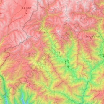
Name: Paro District topographic map, elevation, terrain.
Location: Paro District, Bhutan (27.18834 89.12806 27.78384 89.54903)
Average elevation: 12,152 ft
Minimum elevation: 5,400 ft
Maximum elevation: 18,675 ft
Other topographic maps
Click on a map to view its topography, its elevation and its terrain.
Tashigang
Bhutan > Dagana District > Tseza Gewog
Tashigang, Tseza Gewog, Dagana District, Bhutan
Average elevation: 7,694 ft
Chukha
Bhutan > Chukha > Bjagchhog Gewog > Mebisa
Chukha, Mebisa, Bjagchhog Gewog, Chukha, Bhutan
Average elevation: 7,457 ft
Tagtshang
Bhutan > Paro District > Tsento Gewog > Nyechhu_Shar-ri
Tagtshang, Nyechhu_Shar-ri, Tsento Gewog, Paro District, Bhutan
Average elevation: 10,135 ft
Phuntsholing
Bhutan > Chukha > Phuentshogling Gewog > Dzongkhag Thromde
Phuntsholing, Dzongkhag Thromde, Phuentshogling Gewog, Chukha, Bhutan
Average elevation: 1,299 ft
Daga
Bhutan > Dagana District > Tseza Gewog > Karlingzingkha
Daga, Karlingzingkha, Tseza Gewog, Dagana District, Bhutan
Average elevation: 5,846 ft
Thimphu
Bhutan > Thimphu District > Chang Gewog
Thimphu, Chang Gewog, Thimphu, Thimphu District, 11001, Bhutan
Average elevation: 10,240 ft
Nyishog Gewog
Bhutan > Wangdue Phodrang District > Nyishog Gewog
Nyishog Gewog, Wangdue Phodrang District, Bhutan
Average elevation: 9,423 ft
Dopshar-ri Gewog
Dopshar-ri Gewog, Paro District, 12001, Bhutan
Average elevation: 9,281 ft
Gedu
Bhutan > Chukha District > Gedu
Gedu, Bongo Gewog, Chukha District, Bhutan
Average elevation: 6,234 ft