
Make a donation
Gear up for your next adventure:
As an Amazon Associate, this site earns from qualifying purchases at no extra cost to you.
泽库县 topographic map
Click on the map to display elevation.
Make a donation
Gear up for your next adventure:
As an Amazon Associate, this site earns from qualifying purchases at no extra cost to you.
About this map
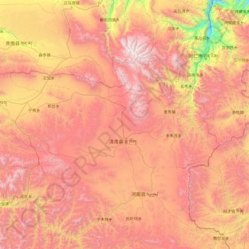
Name: 泽库县 topographic map, elevation, terrain.
Location: 泽库县, 黄南藏族自治州, 青海省, 中国 (34.42279 100.77472 35.82279 102.17472)
Average elevation: 11,959 ft
Minimum elevation: 7,507 ft
Maximum elevation: 16,253 ft
Make a donation
Gear up for your next adventure:
As an Amazon Associate, this site earns from qualifying purchases at no extra cost to you.
Other topographic maps
Click on a map to view its topography, its elevation and its terrain.
果洛藏族自治州
果洛藏族自治州东临甘肃省甘南藏族自治州和青海省黄南藏族自治州;南接四川省阿坝藏族羌族自治州和甘孜藏族自治州;西与青海省玉树藏族自治州毗连;北和青海省海西蒙古族藏族自治州、海南藏族自治州接壤。全州总面积7.64万平方千米,占青海省总面积的10.54%。平均海拔4200米以上,海拔4000—5000米的地区约占全区面积的80%左右,西北部海拔多在4000—5000米之间,地形起伏不大,高差多在500—1000米之间,坡度较缓;东南部海拔在3500—4000之间,但地形起伏大,高差一般在1000—2100米之间,坡度45°—50°,最大80°以上。整个地形自西北向东南倾斜,西北高,多丘陵,地形平缓;东南低,多高山,坡陡谷…
Average elevation: 13,704 ft
Make a donation
Gear up for your next adventure:
As an Amazon Associate, this site earns from qualifying purchases at no extra cost to you.
Make a donation
Gear up for your next adventure:
As an Amazon Associate, this site earns from qualifying purchases at no extra cost to you.
Make a donation
Gear up for your next adventure:
As an Amazon Associate, this site earns from qualifying purchases at no extra cost to you.
Make a donation
Gear up for your next adventure:
As an Amazon Associate, this site earns from qualifying purchases at no extra cost to you.
海南藏族自治州
境内地形以山地为主,四周环山,西部與西南部有鄂拉山。盆地居中,高原丘陵和河谷台地相间其中,地势起伏较大,复杂多样。全州平均海拔在3000米以上,最高海拔5305米,最低海拔2168米。山地是全州主要地貌类型,占全州陆地总面积的42.3%,丘陵及残山占全州陆地总面积的11%;中海拔平原和台地占全州陆地总面积的46.7%,其中河谷阶地为12.4%。黄河横贯中南部5县20个乡镇,长411.3公里,有支流101条;以青海湖为主的6个内陆水系有支流40余条。青海湖是中国最大的内陆高原微咸水湖,位于州境北部。湖面积4573平方千米,湖水总容量854亿立方米,矿化度在12.5—13.2克/升之间。湖面海拔3196米,平均水深19…
Average elevation: 11,798 ft
海西蒙古族藏族自治州
海西州境域主要由昆仑山、阿尔金山、祁连山环抱的柴达木盆地和唐古拉山北麓高原两部分组成,主体是柴达木盆地,平均海拔3000米。柴达木盆地从边缘至中心依次为高山、丘陵、戈壁、平原、湖沼5个地貌类型,呈环带状分布,西北高东南低,盆地南部多咸水湖、盐土沼泽,有大面积的新月形沙丘和沙丘链分布;盆地北部断续分布着赛什腾山、绿梁山、锡铁山、牦牛山等山脉,将盆地北部分割成花海子、马海、大柴旦、小柴旦、德令哈、希里沟等小型山间盆地和谷地。州境南缘的唐古拉地区海拔多在4500米以上。
Average elevation: 12,267 ft
Make a donation
Gear up for your next adventure:
As an Amazon Associate, this site earns from qualifying purchases at no extra cost to you.
Make a donation
Gear up for your next adventure:
As an Amazon Associate, this site earns from qualifying purchases at no extra cost to you.
Make a donation
Gear up for your next adventure:
As an Amazon Associate, this site earns from qualifying purchases at no extra cost to you.
Make a donation
Gear up for your next adventure:
As an Amazon Associate, this site earns from qualifying purchases at no extra cost to you.
Make a donation
Gear up for your next adventure:
As an Amazon Associate, this site earns from qualifying purchases at no extra cost to you.
玉树藏族自治州
玉树藏族自治州北与海西蒙古族藏族自治州为邻,东与果洛藏族自治州相通,东南与四川省甘孜藏族自治州毗连,南及西南同西藏自治区的昌都市和那曲地区交界,西北角与新疆维吾尔自治区的巴音郭楞蒙古自治州接壤。全州总面积26.7万平方千米。北有昆仑山脉和巴颜喀拉山脉,南有唐古拉山,东接川西高山峡谷,西连藏北高原,是长江、黄河和澜沧江的发源地。地势南北高、中间低,西髙东低。冰缘地貌占总面积的70%以上,冻融作用强烈。中西部和北部以低山丘陵、宽谷、湖盆和滩地为主;中部以东、以南为髙原山地和髙山峡谷地貌。全州平均海拔4200米以上,最髙峰布喀达板峰海拔6860米,最低处金沙江海拔3335米,大部分地区海拔在4000—5000米之间。境内…
Average elevation: 14,672 ft
Make a donation
Gear up for your next adventure:
As an Amazon Associate, this site earns from qualifying purchases at no extra cost to you.
乐都区
乐都境内山峦层迭,沟壑纵横,湟水河自西向东流径全境。以湟水为界,北部和南部分属祁连山地槽褶皱系之间隆起带和拉脊山地向斜褶皱带两个构成单位,由西部大峡隆起与东部老鸦峡形成乐都盆地。总的地势由西向东倾斜,西高东低,呈阶梯分布,海拔在1850米一4480米之间。全县自然区为典型的青藏高原与黄土高原的过渡地带,分为四种类型:海拔3000米至雪线(3700米)以下为石山森林草原区,沟谷深切,山体陡峭;海拔2800—3000米之间为脑山农耕区,地形低缓、浑圆、波状起伏,冲沟切断不深;海拔2000—2800米之间为浅山黄土丘陵区,沟壑纵横,沟深坡大,水土流失严重,植被稀疏;海拔1850—2000米之间为川水河谷盆地,地势平坦,土…
Average elevation: 8,871 ft
Make a donation
Gear up for your next adventure:
As an Amazon Associate, this site earns from qualifying purchases at no extra cost to you.
Make a donation
Gear up for your next adventure:
As an Amazon Associate, this site earns from qualifying purchases at no extra cost to you.
Make a donation
Gear up for your next adventure:
As an Amazon Associate, this site earns from qualifying purchases at no extra cost to you.
Make a donation
Gear up for your next adventure:
As an Amazon Associate, this site earns from qualifying purchases at no extra cost to you.
Make a donation
Gear up for your next adventure:
As an Amazon Associate, this site earns from qualifying purchases at no extra cost to you.
Make a donation
Gear up for your next adventure:
As an Amazon Associate, this site earns from qualifying purchases at no extra cost to you.
Make a donation
Gear up for your next adventure:
As an Amazon Associate, this site earns from qualifying purchases at no extra cost to you.
Make a donation
Gear up for your next adventure:
As an Amazon Associate, this site earns from qualifying purchases at no extra cost to you.
Make a donation
Gear up for your next adventure:
As an Amazon Associate, this site earns from qualifying purchases at no extra cost to you.
Make a donation
Gear up for your next adventure:
As an Amazon Associate, this site earns from qualifying purchases at no extra cost to you.
Make a donation
Gear up for your next adventure:
As an Amazon Associate, this site earns from qualifying purchases at no extra cost to you.
泽库县
泽库县(藏語:རྩེ་ཁོག,威利转写:rtse khog,藏语拼音:Zêkog)是中华人民共和国青海省黄南藏族自治州下辖的一个县,位于黄南州中南部。东与甘肃省夏河县毗邻,南、西、北分别与河南蒙古自治县、同德县、贵南县相连,东北与同仁县接壤,离州府隆务镇97公里,距省会西宁约285公里。县辖4乡3镇,64个行政村,12个居民社区。县境平均海拔3700公尺,年均气温-2.4℃,全年无绝对无霜期,冬长无夏,春秋相连。是一个以藏族为主体民族的纯牧业县,曾是国家扶贫开发重点县。邮政编码811400,县政府驻泽曲镇。
Average elevation: 12,093 ft
Make a donation
Gear up for your next adventure:
As an Amazon Associate, this site earns from qualifying purchases at no extra cost to you.
Make a donation
Gear up for your next adventure:
As an Amazon Associate, this site earns from qualifying purchases at no extra cost to you.
Make a donation
Gear up for your next adventure:
As an Amazon Associate, this site earns from qualifying purchases at no extra cost to you.
Make a donation
Gear up for your next adventure:
As an Amazon Associate, this site earns from qualifying purchases at no extra cost to you.