
Baranof Island topographic map
Interactive map
Click on the map to display elevation.
About this map
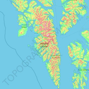
Name: Baranof Island topographic map, elevation, terrain.
Location: Baranof Island, Alaska, 99835, United States (56.16121 -135.69305 57.56329 -134.61583)
Average elevation: 381 ft
Minimum elevation: -16 ft
Maximum elevation: 5,282 ft
Other topographic maps
Click on a map to view its topography, its elevation and its terrain.
Anchorage
United States > Alaska > Anchorage
Anchorage, Alaska, United States
Average elevation: 1,037 ft
Point Barrow
United States > Alaska > North Slope
Point Barrow, North Slope, Alaska, United States
Average elevation: 0 ft
Homer
United States > Alaska > Kenai Peninsula
Homer, Kenai Peninsula, Alaska, United States
Average elevation: 341 ft
Fairbanks
United States > Alaska > Fairbanks North Star
Fairbanks, Fairbanks North Star, Alaska, United States
Average elevation: 479 ft
Denali National Park
United States > Alaska > Denali
Denali National Park, Denali, Alaska, United States
Average elevation: 2,733 ft
Cinder Cone
United States > Alaska > Lake and Peninsula
Cinder Cone, Lake and Peninsula, Alaska, United States
Average elevation: 6,047 ft
Umnak Island
United States > Alaska > Aleutians West Census Area
Umnak Island, Aleutians West Census Area, Alaska, 99638, United States
Average elevation: 210 ft
Fairbanks
United States > Alaska > Fairbanks North Star
Fairbanks, Fairbanks North Star, Alaska, United States
Average elevation: 482 ft
Sealion Islands
United States > Alaska > Sitka
Sealion Islands, Sitka, Alaska, United States
Average elevation: 276 ft
Fort Greely
United States > Alaska > Unorganized Borough
Fort Greely, Unorganized Borough, Alaska, 99731, United States
Average elevation: 1,903 ft
Bethel
United States > Alaska > Unorganized Borough
Bethel, Unorganized Borough, Alaska, 99559, United States
Average elevation: 46 ft
Copper River
United States > Alaska > Unorganized Borough
Copper River, Unorganized Borough, Alaska, United States
Average elevation: 2,572 ft
Wilson Village
United States > Alaska > Anchorage > Anchorage
Wilson Village, Anchorage, Alaska, 99598, United States
Average elevation: 157 ft
Bethel
United States > Alaska > Unorganized Borough > Bethel
Bethel, Unorganized Borough, Alaska, United States
Average elevation: 30 ft
Dillingham
United States > Alaska > Unorganized Borough
Dillingham, Unorganized Borough, Alaska, United States
Average elevation: 62 ft
Wasilla
United States > Alaska > Matanuska-Susitna
Wasilla, Matanuska-Susitna, Alaska, United States
Average elevation: 322 ft
Hot Spring Creek
United States > Alaska > Unorganized Borough
Hot Spring Creek, Unorganized Borough, Alaska, United States
Average elevation: 1,181 ft
Juno Mountain
United States > Alaska > Ketchikan Gateway
Juno Mountain, Ketchikan Gateway, Alaska, 99901, United States
Average elevation: 1,437 ft
Tee Harbor
United States > Alaska > Juneau
Tee Harbor, Juneau, Alaska, United States
Average elevation: 397 ft
Redoubt
United States > Alaska > Anchorage
Redoubt, Anchorage, Alaska, United States
Average elevation: 161 ft
Ketchikan
United States > Alaska > Ketchikan
Ketchikan, Ketchikan Gateway, Alaska, 99901, United States
Average elevation: 489 ft
Taku Harbor
United States > Alaska > Juneau
Taku Harbor, Juneau, Alaska, United States
Average elevation: 650 ft
Lemon Creek
United States > Alaska > Juneau
Lemon Creek, Juneau, Alaska, United States
Average elevation: 1,414 ft
Lena Beach
United States > Alaska > Juneau > Lena Beach
Lena Beach, Juneau, Alaska, United States
Average elevation: 338 ft
West Juneau
United States > Alaska > Juneau
West Juneau, Juneau, Alaska, United States
Average elevation: 361 ft
Fairhaven
United States > Alaska > Juneau
Fairhaven, Juneau, Alaska, United States
Average elevation: 328 ft
Dobson Landing
United States > Alaska > Juneau
Dobson Landing, Juneau, Alaska, United States
Average elevation: 322 ft
Vanderbilt Hill
United States > Alaska > Juneau
Vanderbilt Hill, Juneau, Alaska, 99811, United States
Average elevation: 413 ft
Saint Terese
United States > Alaska > Juneau
Saint Terese, Juneau, Alaska, United States
Average elevation: 272 ft
Mendenhall Valley
United States > Alaska > Juneau
Mendenhall Valley, Juneau, Alaska, United States
Average elevation: 499 ft
Auke Bay
United States > Alaska > Juneau
Auke Bay, Juneau, Alaska, United States
Average elevation: 10 ft
Gustavus
United States > Alaska > Unorganized Borough
Gustavus, Unorganized Borough, Alaska, 99826, United States
Average elevation: 148 ft
Wainwright
United States > Alaska > North Slope
Wainwright, North Slope, Alaska, 99782, United States
Average elevation: 16 ft
Anchorage
United States > Alaska > Anchorage
Anchorage, Alaska, 99501, United States
Average elevation: 407 ft
Fairbanks
United States > Alaska > Fairbanks North Star
Fairbanks, Fairbanks North Star, Alaska, 99703, United States
Average elevation: 709 ft
Mosquito Lake
United States > Alaska > Haines
Mosquito Lake, Haines, Alaska, United States
Average elevation: 1,230 ft
Excursion Inlet
United States > Alaska > Haines
Excursion Inlet, Haines, Alaska, United States
Average elevation: 486 ft
Hoonah
United States > Alaska > Unorganized Borough
Hoonah, Unorganized Borough, Alaska, 99829, United States
Average elevation: 358 ft
Mud Bay
United States > Alaska > Haines
Mud Bay, Haines, Alaska, United States
Average elevation: 157 ft
Cube Cove
United States > Alaska > Unorganized Borough
Cube Cove, Unorganized Borough, Alaska, United States
Average elevation: 282 ft
Angoon
United States > Alaska > Unorganized Borough > Angoon
Angoon, Unorganized Borough, Alaska, 99820, United States
Average elevation: 62 ft