
Democratic Republic of the Congo topographic map
Interactive map
Click on the map to display elevation.
About this map
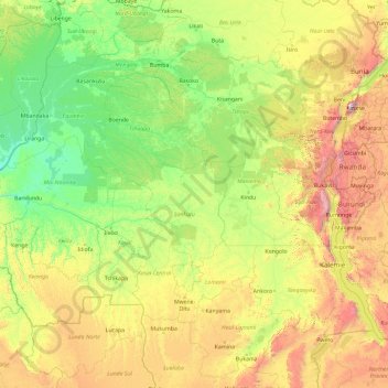
Name: Democratic Republic of the Congo topographic map, elevation, terrain.
Location: Democratic Republic of the Congo (-9.98143 16.82226 4.01857 30.82226)
Average elevation: 2,352 ft
Minimum elevation: 942 ft
Maximum elevation: 14,144 ft
The tropical climate also produced the Congo River system which dominates the region topographically along with the rainforest it flows through, though they are not mutually exclusive. The name for the Congo state is derived in part from the river. The river basin (meaning the Congo River and all of its myriad tributaries) occupies nearly the entire country and an area of nearly 1,000,000 km2 (390,000 sq mi). The river and its tributaries form the backbone of Congolese economics and transportation. Major tributaries include the Kasai, Sangha, Ubangi, Ruzizi, Aruwimi, and Lulonga.
Other topographic maps
Click on a map to view its topography, its elevation and its terrain.
Lungutu
Democratic Republic of the Congo > South Kivu > Uvira
Lungutu, Plaine de la Ruzizi (chefferie), Uvira, South Kivu, Democratic Republic of the Congo
Average elevation: 3,123 ft
Kabare (chefferie)
Democratic Republic of the Congo > South Kivu > Kabare
Kabare (chefferie), Kabare, South Kivu, Democratic Republic of the Congo
Average elevation: 6,030 ft
Mutshatsha
Democratic Republic of the Congo > Lualaba > Mutshatsha
Mutshatsha, Lualaba, Democratic Republic of the Congo
Average elevation: 4,052 ft
Boende
Democratic Republic of the Congo > Tshuapa
Boende, Tshuapa, Democratic Republic of the Congo
Average elevation: 1,122 ft
Luilu
Democratic Republic of the Congo > Lualaba > Mutshatsha
Luilu, Mutshatsha, Lualaba, Democratic Republic of the Congo
Average elevation: 4,672 ft
Musonoie
Democratic Republic of the Congo > Lualaba > Mutshatsha
Musonoie, Mutshatsha, Lualaba, Democratic Republic of the Congo
Average elevation: 4,797 ft
Mombele
Democratic Republic of the Congo > Kinshasa
Mombele, Nsele, Kinshasa, Democratic Republic of the Congo
Average elevation: 935 ft
Lubero
Democratic Republic of the Congo > North Kivu > Lubero
Lubero, Baswaga, Lubero, North Kivu, Democratic Republic of the Congo
Average elevation: 6,696 ft
Kinkole
Democratic Republic of the Congo > Haut-Katanga > Ville de Lubumbashi > Lubumbashi
Kinkole, Mampala, Lubumbashi, Ville de Lubumbashi, Haut-Katanga, Democratic Republic of the Congo
Average elevation: 3,980 ft
Nsele
Democratic Republic of the Congo > Kinshasa
Nsele, Kinshasa, Democratic Republic of the Congo
Average elevation: 1,414 ft
Kimbembe
Democratic Republic of the Congo > Haut-Katanga > Ville de Lubumbashi
Kimbembe, Annexe, Ville de Lubumbashi, Haut-Katanga, Democratic Republic of the Congo
Average elevation: 4,137 ft
25 km
Democratic Republic of the Congo > Mai-Ndombe > Mai-Ndombe
25 km, Mai-Ndombe, Democratic Republic of the Congo
Average elevation: 994 ft
Orientale
Democratic Republic of the Congo
Orientale, Democratic Republic of the Congo
Average elevation: 2,392 ft
North Kivu
Democratic Republic of the Congo
North Kivu, Democratic Republic of the Congo
Average elevation: 3,901 ft
Kapama
Democratic Republic of the Congo > Kasai
Kapama, Kasai, Democratic Republic of the Congo
Average elevation: 1,965 ft
Funa
Democratic Republic of the Congo > Kinshasa > Kingabwa
Funa, Kingabwa Pêcheur, Kingabwa, Limete, Kinshasa, Democratic Republic of the Congo
Average elevation: 899 ft
Lukunga
Democratic Republic of the Congo > Kinshasa
Lukunga, Matete, Kinshasa, Democratic Republic of the Congo
Average elevation: 965 ft
Tshangu
Democratic Republic of the Congo > Kinshasa
Tshangu, Masina, Kinshasa, Democratic Republic of the Congo
Average elevation: 961 ft
Terrain
Democratic Republic of the Congo > North Kivu > Beni
Terrain, Beni, North Kivu, Democratic Republic of the Congo
Average elevation: 3,556 ft
Radio
Democratic Republic of the Congo > North Kivu > Masisi
Radio, Masisi, North Kivu, Democratic Republic of the Congo
Average elevation: 6,168 ft
Yata
Democratic Republic of the Congo > Tshopo
Yata, Tshopo, Democratic Republic of the Congo
Average elevation: 1,237 ft
Londo
Democratic Republic of the Congo > Mai-Ndombe > Mai-Ndombe
Londo, Mai-Ndombe, Democratic Republic of the Congo
Average elevation: 1,004 ft
Kavale
Democratic Republic of the Congo > North Kivu > Lubero
Kavale, Baswaga, Lubero, North Kivu, Democratic Republic of the Congo
Average elevation: 5,410 ft
Kinzie
Democratic Republic of the Congo > Kwilu > Kwilu
Kinzie, Kwilu, Democratic Republic of the Congo
Average elevation: 1,050 ft
Mai-Ndombe
Democratic Republic of the Congo
Mai-Ndombe, Democratic Republic of the Congo
Average elevation: 1,175 ft
Kongo-Central
Democratic Republic of the Congo
Kongo-Central, Democratic Republic of the Congo
Average elevation: 1,155 ft
Upper Uele
Democratic Republic of the Congo
Upper Uele, Democratic Republic of the Congo
Average elevation: 2,372 ft
Lualaba
Democratic Republic of the Congo
Lualaba, Democratic Republic of the Congo
Average elevation: 3,445 ft
Pawa
Democratic Republic of the Congo > Ituri > Mambasa
Pawa, Mambasa, Ituri, Democratic Republic of the Congo
Average elevation: 3,757 ft
Durba
Democratic Republic of the Congo > Upper Uele
Durba, Upper Uele, Democratic Republic of the Congo
Average elevation: 2,733 ft
Tshopo
Democratic Republic of the Congo
Tshopo, Democratic Republic of the Congo
Average elevation: 1,693 ft
Maniema
Democratic Republic of the Congo
Maniema, Democratic Republic of the Congo
Average elevation: 2,083 ft
Central Kasai
Democratic Republic of the Congo
Central Kasai, Democratic Republic of the Congo
Average elevation: 2,178 ft
mongala
Democratic Republic of the Congo
mongala, Democratic Republic of the Congo
Average elevation: 1,358 ft
Équateur
Democratic Republic of the Congo
Équateur, Democratic Republic of the Congo
Average elevation: 1,122 ft
South Kivu
Democratic Republic of the Congo
South Kivu, Democratic Republic of the Congo
Average elevation: 3,238 ft
Sud-Ubangi
Democratic Republic of the Congo
Sud-Ubangi, Democratic Republic of the Congo
Average elevation: 1,381 ft
Bandema
Democratic Republic of the Congo > Nord-Ubangi > Bosobolo
Bandema, Bosobolo, Nord-Ubangi, Democratic Republic of the Congo
Average elevation: 1,476 ft
Valo
Democratic Republic of the Congo > Ituri > Djugu
Valo, Djugu, Ituri, Democratic Republic of the Congo
Average elevation: 6,716 ft
Coq
Democratic Republic of the Congo > Sud-Ubangi > Libenge
Coq, Libenge, Sud-Ubangi, Democratic Republic of the Congo
Average elevation: 1,125 ft
Lubumbashi
Democratic Republic of the Congo > Haut-Katanga > Ville de Lubumbashi
Lubumbashi, Ville de Lubumbashi, Haut-Katanga, Democratic Republic of the Congo
Average elevation: 4,098 ft
Rutshuru
Democratic Republic of the Congo > North Kivu
Rutshuru, North Kivu, Democratic Republic of the Congo
Average elevation: 5,135 ft
Bandundu
Democratic Republic of the Congo
Bandundu, Democratic Republic of the Congo
Average elevation: 1,821 ft
Kisangani
Democratic Republic of the Congo > Tshopo
Kisangani, Tshopo, Democratic Republic of the Congo
Average elevation: 1,362 ft
Isiro
Democratic Republic of the Congo > Upper Uele > Isiro
Isiro, Upper Uele, Democratic Republic of the Congo
Average elevation: 2,425 ft
Bwisha
Democratic Republic of the Congo > North Kivu > Rutshuru
Bwisha, Rutshuru, North Kivu, Democratic Republic of the Congo
Average elevation: 5,217 ft
Kwango
Democratic Republic of the Congo
Kwango, Democratic Republic of the Congo
Average elevation: 1,926 ft
Katanga
Democratic Republic of the Congo
Katanga, Democratic Republic of the Congo
Average elevation: 3,307 ft
Kasai
Democratic Republic of the Congo
Kasai, Democratic Republic of the Congo
Average elevation: 1,998 ft
Bapukeli
Democratic Republic of the Congo > Ituri > Mambasa > Bapukeli
Bapukeli, Mambasa, Ituri, Democratic Republic of the Congo
Average elevation: 2,562 ft