
Make a donation
Gear up for your next adventure:
As an Amazon Associate, this site earns from qualifying purchases at no extra cost to you.
Signal Hill topographic map
Click on the map to display elevation.
Make a donation
Gear up for your next adventure:
As an Amazon Associate, this site earns from qualifying purchases at no extra cost to you.
About this map
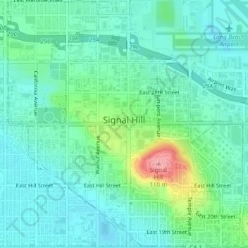
Name: Signal Hill topographic map, elevation, terrain.
Location: Signal Hill, Los Angeles County, California, United States (33.78979 -118.18493 33.81891 -118.14963)
Average elevation: 92 ft
Minimum elevation: 10 ft
Maximum elevation: 354 ft
California trails, hiking, mountain biking, running and outdoor activities
Make a donation
Gear up for your next adventure:
As an Amazon Associate, this site earns from qualifying purchases at no extra cost to you.
Other topographic maps
Click on a map to view its topography, its elevation and its terrain.
Pollock Pines
United States > California > El Dorado County
Pollock Pines is a census-designated place (CDP) in El Dorado County, California, United States. It is part of the Sacramento–Arden-Arcade–Roseville Metropolitan Statistical Area. Pollock Pines lies at an elevation of 3,980 feet (1,210 m) in the Sierra Nevada. The population was 6,871 at the 2010 census,…
Average elevation: 3,681 ft
Klamath
United States > California > Del Norte County
Klamath (Tolowa: Taa-chit) is an unincorporated, rural census-designated place (CDP) in Del Norte County, California, situated on US Route 101 inland from the mouth of the Klamath River. The current population of Klamath, California is 632 based on US Census estimates, down from 779 recorded in the 2010 US…
Average elevation: 623 ft
Make a donation
Gear up for your next adventure:
As an Amazon Associate, this site earns from qualifying purchases at no extra cost to you.
Crescent City
United States > California > Del Norte County
The topography of the sea floor surrounding Crescent City has the effect of focusing tsunamis. According to researchers at Humboldt State University and the University of Southern California, the city experienced tsunami conditions 31 times between the years 1933 and 2008. Although many of these incidents were…
Average elevation: 20 ft
Gilroy
United States > California > Santa Clara County > Gilroy
Gilroy is approximately 16 miles (26 km) south of San Jose, California (Bailey Avenue (37.206770, -121.729150) to Monterey/Day Road (37.038210, -121.584480)) on U.S. Route 101 and 19 miles (31 km) inland from the Pacific Coast. Despite its apparent close proximity to San Jose, it is important to note that…
Average elevation: 715 ft
Bakersfield
United States > California > Kern County > Bakersfield
Most of Bakersfield’s major streets are six-lane divided roads with bike lanes, with almost every street in the city having proper lane signage for bicycle traffic. Bikes are a popular method of transportation in Bakersfield, due to the city’s relatively flat topography and grid-like street system. Newer…
Average elevation: 528 ft
Make a donation
Gear up for your next adventure:
As an Amazon Associate, this site earns from qualifying purchases at no extra cost to you.
Susanville
United States > California > Lassen County
Susanville (formerly known as Rooptown) is a town in and is the county seat of Lassen County, California, United States. Susanville is located on the Susan River in the southern part of the county, at an elevation of 4,186 feet (1,276 m). Its population is 16,728 as of the 2020 census, down from 17,947 from…
Average elevation: 4,413 ft
La Jolla
United States > California > San Diego County > San Diego > La Jolla
Average elevation: 121 ft
Fort Irwin
United States > California > San Bernardino County
Fort Irwin National Training Center (Fort Irwin NTC) is a major training area for the United States military in the Mojave Desert in northern San Bernardino County, California. Fort Irwin is at an average elevation of 2,454 feet (748 m). It is located 37 miles (60 km) northeast of Barstow, in the Calico…
Average elevation: 2,539 ft
Make a donation
Gear up for your next adventure:
As an Amazon Associate, this site earns from qualifying purchases at no extra cost to you.
Placerville
United States > California > Placerville
The region east of Placerville, popularly known as Apple Hill and Pleasant Valley, is becoming a center for wine production. The wine region is officially designated as the El Dorado AVA. The largest wineries in the area are Boeger, Lava Cap and Madrona, but most of the 30 plus wineries surrounding Placerville…
Average elevation: 1,926 ft
Cardiff-by-the-Sea
United States > California > Encinitas > Cardiff-by-the-Sea
Average elevation: 105 ft
Make a donation
Gear up for your next adventure:
As an Amazon Associate, this site earns from qualifying purchases at no extra cost to you.
Olympic Valley
United States > California > Placer County > Olympic Valley
Average elevation: 6,896 ft
Mount Lukens
United States > California > Los Angeles County > Los Angeles
It is in the Sunland-Tujunga community within the northeast corner of the city of Los Angeles, above the Crescenta Valley. The summit, at 5,075 feet (1,547 m) in elevation, is the highest point within the city limits. The summit's elevation makes Los Angeles the city with the largest difference between high…
Average elevation: 3,858 ft
San Gorgonio Pass
United States > California > Riverside County
The San Gorgonio Pass, or Banning Pass, is a 2,600 ft (790 m) elevation gap on the rim of the Great Basin between the San Bernardino Mountains to the north and the San Jacinto Mountains to the south. The pass was formed by the San Andreas Fault, a major transform fault between the Pacific plate and the North…
Average elevation: 1,614 ft
Make a donation
Gear up for your next adventure:
As an Amazon Associate, this site earns from qualifying purchases at no extra cost to you.
Point Arena
United States > California > Mendocino County
Point Arena, formerly known as Punta Arena (Spanish for "Sandy Point") is a small coastal city in Mendocino County, California, United States. Point Arena is located 32 miles (51 km) west of Hopland, at an elevation of 118 feet (36 m). The population was 460 at the 2020 census, making it one of the smallest…
Average elevation: 39 ft
Make a donation
Gear up for your next adventure:
As an Amazon Associate, this site earns from qualifying purchases at no extra cost to you.
Make a donation
Gear up for your next adventure:
As an Amazon Associate, this site earns from qualifying purchases at no extra cost to you.
General Sherman Tree
United States > California > Tulare County
General Sherman is a giant sequoia (Sequoiadendron giganteum) tree located at an elevation of 2,109 m (6,919 ft) above sea level in the Giant Forest of Sequoia National Park in Tulare County, in the U.S. state of California. By volume, it is the largest known living single-stem tree on Earth.
Average elevation: 6,936 ft
Make a donation
Gear up for your next adventure:
As an Amazon Associate, this site earns from qualifying purchases at no extra cost to you.
Independence
Independence is a census-designated place in Inyo County, California. Independence is located 41 miles (66 km) south-southeast of Bishop, at an elevation of 3930 feet (1198 m). It is the county seat of Inyo County, California. The population of this census-designated place was 669 at the 2010 census, up from…
Average elevation: 3,934 ft
Make a donation
Gear up for your next adventure:
As an Amazon Associate, this site earns from qualifying purchases at no extra cost to you.
Make a donation
Gear up for your next adventure:
As an Amazon Associate, this site earns from qualifying purchases at no extra cost to you.
Make a donation
Gear up for your next adventure:
As an Amazon Associate, this site earns from qualifying purchases at no extra cost to you.
Make a donation
Gear up for your next adventure:
As an Amazon Associate, this site earns from qualifying purchases at no extra cost to you.
Make a donation
Gear up for your next adventure:
As an Amazon Associate, this site earns from qualifying purchases at no extra cost to you.
Make a donation
Gear up for your next adventure:
As an Amazon Associate, this site earns from qualifying purchases at no extra cost to you.
Alta Sierra
United States > California > Nevada County
Alta Sierra was laid out by property developers in the 1960s. Alta Sierra is a golf course community, with homes built around the Alta Sierra Country Club, a semi-private 18 hole course built in 1964. The community has a member-owned airport with a 2800-foot runway. The community is located just east of…
Average elevation: 1,978 ft
Rancho Santa Fe
The climate of Rancho Santa Fe is, for the most part, typical of the San Diego metropolitan area though its higher elevation and inland location lends itself to larger temperature variations.
Average elevation: 203 ft
Make a donation
Gear up for your next adventure:
As an Amazon Associate, this site earns from qualifying purchases at no extra cost to you.
Thousand Oaks
United States > California > Ventura County > Thousand Oaks
The northern parts consist of mountainous terrain in the Simi Hills, Conejo Mountains and Mount Clef Ridge. Narrow canyons such as Hill Canyon cut through the steeper mountainous areas. Conejo Mountain and Conejo Grade are found in westernmost Newbury Park, while the southernmost parts of Thousand Oaks are…
Average elevation: 994 ft
Make a donation
Gear up for your next adventure:
As an Amazon Associate, this site earns from qualifying purchases at no extra cost to you.
Lancaster
United States > California > Lancaster
According to the United States Census Bureau, the city has a total area of 94.5 square miles (245 km2), of which 94.3 square miles (244 km2) is land and 0.3 square miles (0.78 km2) (0.29%) is water. Lancaster's elevation is 2,350 feet (720 m) above sea level on a high, flat valley surrounded by pristine…
Average elevation: 2,582 ft
Mariposa
United States > California > Mariposa County
Mariposa is located at 37°29′06″N 119°57′59″W / 37.48500°N 119.96639°W / 37.48500; -119.96639, at 1,949 feet (594 m) in elevation. It lies in the rugged foothills of the Sierra Nevada. Mariposa Creek flows through the town. Soils in the urban area are mostly brown to reddish brown loam of…
Average elevation: 2,257 ft
Make a donation
Gear up for your next adventure:
As an Amazon Associate, this site earns from qualifying purchases at no extra cost to you.
Make a donation
Gear up for your next adventure:
As an Amazon Associate, this site earns from qualifying purchases at no extra cost to you.
El Dorado
United States > California > El Dorado County
El Dorado (Spanish for "The Golden") is an unincorporated community in El Dorado County, California. It is located 4 miles (6.4 km) southwest of Placerville, at an elevation of 1608 feet (490 m). The population was 4,096 at the 2000 census. The town is registered as California Historical Landmark #486. The ZIP…
Average elevation: 1,677 ft
Hemet
United States > California > Hemet
Dedicated to James Simpson, Hemet City Council 1947–48, and mayor 1950 to 1966. Simpson Park is a wilderness park located in the Santa Rosa Hills southeast of Hemet with sheltered picnic area and tables, barbecues, restrooms, and hiking trails. At an elevation of 2,500 feet (760 m), it provides an expansive…
Average elevation: 1,667 ft
Make a donation
Gear up for your next adventure:
As an Amazon Associate, this site earns from qualifying purchases at no extra cost to you.
Marine Terrace
United States > California > San Luis Obispo County > Cambria
Average elevation: 128 ft
Sebastopol
United States > California > Sonoma County
Sebastopol's elevation is 65 to 250 feet (20 to 76 meters) above sea level. Its downtown is at the intersection of State Route 12 and State Route 116 (Gravenstein Highway), approximately 9 mi (14 km) west of U.S. Route 101.
Average elevation: 226 ft
Salton City
United States > California > Imperial County
In the 1970s, most of the buildings constructed along the shoreline, including the city's marina were abandoned due to rising sea elevation. In the 1980s, the Imperial Irrigation District took proactive water conservation measures to reduce the flow of unused canal water into the Salton Sea. Throughout the…
Average elevation: -131 ft
Make a donation
Gear up for your next adventure:
As an Amazon Associate, this site earns from qualifying purchases at no extra cost to you.
Make a donation
Gear up for your next adventure:
As an Amazon Associate, this site earns from qualifying purchases at no extra cost to you.
Newbury Park
United States > California > Ventura County > Thousand Oaks
Newbury Park can be described as a town,[6] community,[94] or section[9] mostly within the Thousand Oaks city limits in addition to rural areas west of Thousand Oaks. Newbury Park is bordered by Lynn Road in the east and the Conejo Grade on the west. It borders the Santa Monica Mountains in the south, while…
Average elevation: 860 ft
Alcatraz Island
United States > California > San Francisco
Alcatraz Island view from the west. Image shot from an altitude of approximately 1,800 ft (549 m).
Average elevation: 0 ft
McCloud
United States > California > Siskiyou County
McCloud is located at 41°15′17″N 122°8′11″W / 41.25472°N 122.13639°W / 41.25472; -122.13639 (41.254682, -122.136321) on the southern slope of Mount Shasta, at an elevation of 3,271 feet (997 m) above sea level.
Average elevation: 3,314 ft
Make a donation
Gear up for your next adventure:
As an Amazon Associate, this site earns from qualifying purchases at no extra cost to you.
Hollywood Riviera
United States > California > Los Angeles County > Torrance > Hollywood Riviera
Average elevation: 164 ft
Make a donation
Gear up for your next adventure:
As an Amazon Associate, this site earns from qualifying purchases at no extra cost to you.
Desert Knolls Manor
United States > California > San Bernardino County > Apple Valley
Average elevation: 3,045 ft
Crescent City
United States > California > Del Norte County
The topography of the sea floor surrounding Crescent City has the effect of focusing tsunamis. According to researchers at Humboldt State University and the University of Southern California, the city experienced tsunami conditions 31 times between the years 1933 and 2008. Although many of these incidents were…
Average elevation: 102 ft
Make a donation
Gear up for your next adventure:
As an Amazon Associate, this site earns from qualifying purchases at no extra cost to you.
Mammoth Lakes
United States > California > Mammoth Lakes
Mammoth Lakes is a town in Mono County, California, the county's only incorporated community. It is located immediately to the east of Mammoth Mountain, at an elevation of 7,880 feet (2,400 m). As of the 2010 United States Census, the population was 8,234, reflecting a 16% increase from the 2000 Census.
Average elevation: 7,165 ft
Make a donation
Gear up for your next adventure:
As an Amazon Associate, this site earns from qualifying purchases at no extra cost to you.