
Tasmania topographic map
Interactive map
Click on the map to display elevation.
About this map
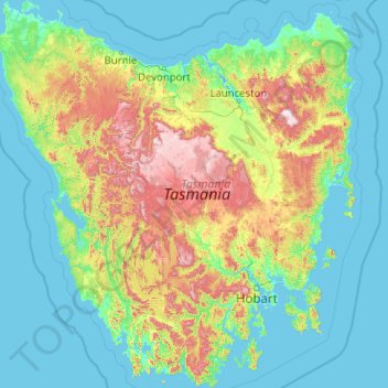
Name: Tasmania topographic map, elevation, terrain.
Location: Tasmania, Australia (-43.64304 144.60734 -40.64139 148.35910)
Average elevation: 722 ft
Minimum elevation: -10 ft
Maximum elevation: 5,000 ft
The most mountainous region is the Central Highlands area, which covers most of the central western parts of the state. The Midlands located in the central east, is fairly flat, and is predominantly used for agriculture, although farming activity is scattered throughout the state. Tasmania's tallest mountain is Mount Ossa at 1,617 m (5,305 ft). Much of Tasmania is still densely forested, with the Southwest National Park and neighbouring areas holding some of the last temperate rain forests in the Southern Hemisphere. The Tarkine, containing Savage River National Park located in the island's far north west, is the largest temperate rainforest area in Australia covering about 3,800 square kilometres (1,500 sq mi). With its rugged topography, Tasmania has a great number of rivers. Several of Tasmania's largest rivers have been dammed at some point to provide hydroelectricity. Many rivers begin in the Central Highlands and flow out to the coast. Tasmania's major population centres are mainly situated around estuaries (some of which are named rivers).
Other topographic maps
Click on a map to view its topography, its elevation and its terrain.
Lake St Clair
Lake St Clair, Central Highlands, Tasmania, Australia
Average elevation: 2,982 ft
Lake Louise
Lake Louise, Grindelwald, West Tamar, Tasmania, Australia
Average elevation: 407 ft
Garden Island
Garden Island, Huon Valley, Tasmania, Australia
Average elevation: 30 ft
Mole Creek
Mole Creek, Meander Valley, Tasmania, 7304, Australia
Average elevation: 1,444 ft
Launceston
Launceston, City of Launceston, Tasmania, Australia
Average elevation: 636 ft
Mount Field
Mount Field, Derwent Valley, Tasmania, 7140, Australia
Average elevation: 2,362 ft
Lake Margaret
Australia > Tasmania > Lake Margaret
Lake Margaret, West Coast, Tasmania, Australia
Average elevation: 2,497 ft
Bream Creek
Australia > Tasmania > Bream Creek
Bream Creek, Sorell, Tasmania, Australia
Average elevation: 115 ft
Cradle Mountain
Cradle Mountain, Kentish, Tasmania, Australia
Average elevation: 2,493 ft
Binalong Bay
Binalong Bay, Break O'Day, Tasmania, Australia
Average elevation: 102 ft
Great Lake
Great Lake, Central Highlands, Tasmania, Australia
Average elevation: 3,593 ft
Strathgordon
Strathgordon, Derwent Valley, Tasmania, 7139, Australia
Average elevation: 1,273 ft
South Bruny
South Bruny, Kingborough, Tasmania, Australia
Average elevation: 154 ft
North Scottsdale
North Scottsdale, Dorset, Tasmania, 7260, Australia
Average elevation: 338 ft
Prospect Vale
Australia > Tasmania > Launceston
Prospect Vale, Launceston, Meander Valley, Tasmania, 7250, Australia
Average elevation: 571 ft
Mount Tyndall
Mount Tyndall, West Coast, Tasmania, Australia
Average elevation: 2,986 ft
Beauty Point
Beauty Point, West Tamar, Tasmania, Australia
Average elevation: 66 ft
West Gawler River
Australia > Tasmania > Sprent > Gawler
West Gawler River, Gawler, Sprent, Central Coast, Tasmania, Australia
Average elevation: 659 ft
Wellington Park
Wellington Park, Derwent Valley, Tasmania, 7054, Australia
Average elevation: 1,375 ft
Mount Ossa
Mount Ossa, Meander Valley, Tasmania, Australia
Average elevation: 3,996 ft
Walls Of Jerusalem
Walls Of Jerusalem, Tasmania, Australia
Average elevation: 4,213 ft
Roger River
Australia > Tasmania > Roger River
Roger River, Circular Head, Tasmania, Australia
Average elevation: 430 ft
Goose Island
Goose Island, Flinders Council, Tasmania, Australia
Average elevation: 3 ft