
Make a donation
Gear up for your next adventure:
As an Amazon Associate, this site earns from qualifying purchases at no extra cost to you.
Athabasca Glacier topographic map
Click on the map to display elevation.
Make a donation
Gear up for your next adventure:
As an Amazon Associate, this site earns from qualifying purchases at no extra cost to you.
About this map
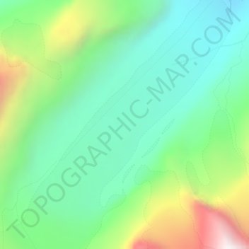
Name: Athabasca Glacier topographic map, elevation, terrain.
Average elevation: 7,746 ft
Minimum elevation: 6,519 ft
Maximum elevation: 10,495 ft
Make a donation
Gear up for your next adventure:
As an Amazon Associate, this site earns from qualifying purchases at no extra cost to you.
Other topographic maps
Click on a map to view its topography, its elevation and its terrain.
Abraham Lake
Canada > Alberta > Census Division No. 9
The Government of Alberta sponsored a contest to name the lake in February 1972, during the final stages of construction of the Bighorn Dam. Students across the province were asked to submit names taking into consideration "historical significance, prominent persons, geography and topography, and the value of…
Average elevation: 6,188 ft
Moraine Lake
Canada > Alberta > Division No. 15
Moraine Lake is a glacially fed lake in Banff National Park, 14 kilometres (8.7 mi) outside the hamlet of Lake Louise, Alberta, Canada. It is situated in the Valley of the Ten Peaks, at an elevation of approximately 1,884 metres (6,181 ft). The lake has a surface area of 50 hectares (120 acres).
Average elevation: 6,893 ft
Banff National Park
Canada > Alberta > Division No. 15
Banff National Park has a subarctic climate with three ecoregions, including montane, subalpine, and alpine. The forests are dominated by Lodgepole pine at lower elevations and Engelmann spruce in higher ones below the treeline, above which is primarily rocks and ice. Mammal species such as the grizzly bear,…
Average elevation: 6,063 ft
Make a donation
Gear up for your next adventure:
As an Amazon Associate, this site earns from qualifying purchases at no extra cost to you.
Make a donation
Gear up for your next adventure:
As an Amazon Associate, this site earns from qualifying purchases at no extra cost to you.
Make a donation
Gear up for your next adventure:
As an Amazon Associate, this site earns from qualifying purchases at no extra cost to you.
Make a donation
Gear up for your next adventure:
As an Amazon Associate, this site earns from qualifying purchases at no extra cost to you.
Make a donation
Gear up for your next adventure:
As an Amazon Associate, this site earns from qualifying purchases at no extra cost to you.
Make a donation
Gear up for your next adventure:
As an Amazon Associate, this site earns from qualifying purchases at no extra cost to you.
Make a donation
Gear up for your next adventure:
As an Amazon Associate, this site earns from qualifying purchases at no extra cost to you.
Make a donation
Gear up for your next adventure:
As an Amazon Associate, this site earns from qualifying purchases at no extra cost to you.
Make a donation
Gear up for your next adventure:
As an Amazon Associate, this site earns from qualifying purchases at no extra cost to you.
Make a donation
Gear up for your next adventure:
As an Amazon Associate, this site earns from qualifying purchases at no extra cost to you.
Town of Cochrane
Cochrane is situated at the base of Big Hill in the Bow River Valley. It sits at an elevation of 1,186 m (3,891 ft). The town is intersected by Highway 1A and Highway 22. Cochrane has a reputation for its western culture, which can easily be felt when one wanders the streets (particularly Main Street). The…
Average elevation: 3,937 ft
Moutain Vew Park
Canada > Alberta > Census Division No. 9 > Rocky Mountain House
Average elevation: 3,209 ft
Make a donation
Gear up for your next adventure:
As an Amazon Associate, this site earns from qualifying purchases at no extra cost to you.
Make a donation
Gear up for your next adventure:
As an Amazon Associate, this site earns from qualifying purchases at no extra cost to you.
Town of Slave Lake
Canada > Alberta > Municipal District of Lesser Slave River
Average elevation: 1,932 ft
Make a donation
Gear up for your next adventure:
As an Amazon Associate, this site earns from qualifying purchases at no extra cost to you.
Kootenay National Park
Canada > Alberta > Improvement District No. 9
Kootenay National Park is a national park of Canada located in southeastern British Columbia. The park consists of 1,406 km2 (543 sq mi) of the Canadian Rockies, including parts of the Kootenay and Park mountain ranges, the Kootenay River and the entirety of the Vermilion River. While the Vermilion River is…
Average elevation: 6,014 ft
Make a donation
Gear up for your next adventure:
As an Amazon Associate, this site earns from qualifying purchases at no extra cost to you.
Wood Buffalo National Park
The park ranges in elevation from 183 m (600 ft) at the Little Buffalo River to 945 m (3,100 ft) in the Caribou Mountains. The park headquarters is located in Fort Smith, with a smaller satellite office in Fort Chipewyan, Alberta. The park contains one of the world's largest fresh water deltas, the…
Average elevation: 994 ft
Lake Claire
Canada > Alberta > Improvement District No. 24
The lake has a total area of 1,436 km2 (554 sq mi), with 21 km2 (8.1 sq mi) island area, and lies at an elevation of 213 m (699 ft). It is the largest lake located entirely within Albertan boundaries. Lake Athabasca, which straddles the border with Saskatchewan, is larger.
Average elevation: 696 ft
Make a donation
Gear up for your next adventure:
As an Amazon Associate, this site earns from qualifying purchases at no extra cost to you.
Columbia Icefield
Canada > Alberta > Improvement District No. 12 > Area A (Kicking Horse/Kinbasket Lake)
Columbia Icefield has an alpine climate (Köppen: ETf), because the weather station is located at an altitude of 1,981.20 m (6,500 ft). The average annual temperature is −2.1 °C (28.2 °F). The month of July is the warmest with an average temperature of 9.1 °C (48.38 °F).
Average elevation: 8,196 ft
Make a donation
Gear up for your next adventure:
As an Amazon Associate, this site earns from qualifying purchases at no extra cost to you.
Lethbridge
Its high elevation of 929 m (3,048 ft) and close proximity to the Rocky Mountains provides Lethbridge with cooler summers than other locations in the Canadian Prairies. These factors protect the city from strong northwest and southwest winds and contribute to frequent chinook winds during the winter.…
Average elevation: 2,976 ft
Make a donation
Gear up for your next adventure:
As an Amazon Associate, this site earns from qualifying purchases at no extra cost to you.
Make a donation
Gear up for your next adventure:
As an Amazon Associate, this site earns from qualifying purchases at no extra cost to you.
Make a donation
Gear up for your next adventure:
As an Amazon Associate, this site earns from qualifying purchases at no extra cost to you.
Wetaskiwin
The city lies at an elevation of 760 m (2,490 ft). Coal Lake, a reservoir developed on the Battle River is located immediately east of the city, and other nearby waterways include Pipestone Creek, Bigstone Creek, Bittern Lake and Bearhills Lake.
Average elevation: 2,493 ft
Make a donation
Gear up for your next adventure:
As an Amazon Associate, this site earns from qualifying purchases at no extra cost to you.