
Viqueque topographic map
Interactive map
Click on the map to display elevation.
About this map
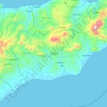
Name: Viqueque topographic map, elevation, terrain.
Location: Viqueque, East Timor (-8.99087 126.04620 -8.62825 126.73764)
Average elevation: 778 ft
Minimum elevation: -3 ft
Maximum elevation: 7,562 ft
Other topographic maps
Click on a map to view its topography, its elevation and its terrain.
Margem de rio
East Timor > Viqueque > Viqueque
Margem de rio, Viqueque, East Timor
Average elevation: 827 ft