
Bobonaro topographic map
Interactive map
Click on the map to display elevation.
About this map
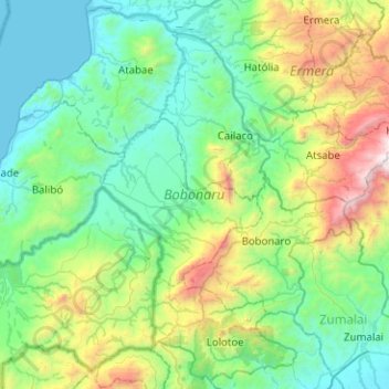
Name: Bobonaro topographic map, elevation, terrain.
Location: Bobonaro, East Timor (-9.21347 124.93176 -8.73584 125.43442)
Average elevation: 1,890 ft
Minimum elevation: 0 ft
Maximum elevation: 8,770 ft
Other topographic maps
Click on a map to view its topography, its elevation and its terrain.
Margem de rio
East Timor > Viqueque > Viqueque
Margem de rio, Viqueque, East Timor
Average elevation: 827 ft