
Aileu topographic map
Interactive map
Click on the map to display elevation.
About this map
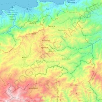
Name: Aileu topographic map, elevation, terrain.
Location: Aileu, East Timor (-8.85042 125.44689 -8.55917 125.81771)
Average elevation: 2,828 ft
Minimum elevation: -3 ft
Maximum elevation: 8,107 ft
Other topographic maps
Click on a map to view its topography, its elevation and its terrain.
Margem de rio
East Timor > Viqueque > Viqueque
Margem de rio, Viqueque, East Timor
Average elevation: 827 ft