
Baucau topographic map
Interactive map
Click on the map to display elevation.
About this map
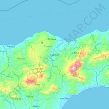
Name: Baucau topographic map, elevation, terrain.
Location: Baucau, East Timor (-8.70311 126.15018 -8.41480 126.81182)
Average elevation: 728 ft
Minimum elevation: 0 ft
Maximum elevation: 7,421 ft
Other topographic maps
Click on a map to view its topography, its elevation and its terrain.
Margem de rio
East Timor > Viqueque > Viqueque
Margem de rio, Viqueque, East Timor
Average elevation: 827 ft