
吉水县 topographic map
Interactive map
Click on the map to display elevation.
About this map
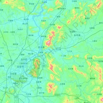
Name: 吉水县 topographic map, elevation, terrain.
Location: 吉水县, 吉安市, 江西省, 331600, 中国 (26.83135 114.86350 27.56722 115.62493)
Average elevation: 417 ft
Minimum elevation: 89 ft
Maximum elevation: 2,851 ft
地处吉泰盆地东北侧,地势东高西低,海拔最高为东山脑海(891米),森林覆盖率达62.8%。主要河流除赣江外,还有恩江,泷江,同江。
Other topographic maps
Click on a map to view its topography, its elevation and its terrain.