
长塘镇 topographic map
Interactive map
Click on the map to display elevation.
About this map
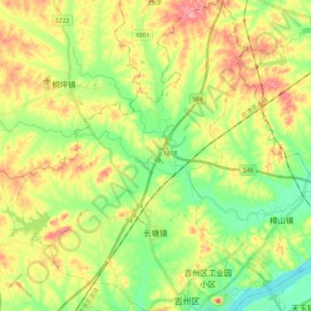
Name: 长塘镇 topographic map, elevation, terrain.
Location: 长塘镇, 吉州区, 吉安市, 江西省, 中国 (27.14015 114.88964 27.29464 115.02454)
Average elevation: 259 ft
Minimum elevation: 112 ft
Maximum elevation: 449 ft
Other topographic maps
Click on a map to view its topography, its elevation and its terrain.