
永新县 topographic map
Interactive map
Click on the map to display elevation.
About this map
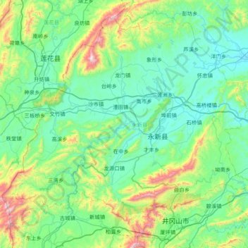
Name: 永新县 topographic map, elevation, terrain.
Location: 永新县, 吉安市, 江西省, 中国 (26.72470 113.82909 27.22624 114.47919)
Average elevation: 1,060 ft
Minimum elevation: 266 ft
Maximum elevation: 4,495 ft
永新縣境總面積2187平方千米,地勢南北高中部低,以山地丘陵為主,縣境山地屬羅霄山脈及其分支餘脈,禾山主峰秋山海拔1391米,為境內第一高峰。山地面積為1074平方千米,丘陵面積800平方千米,河谷平原面積312平方千米。屬亞熱帶季風濕潤性氣候,年平均氣溫18.2度,年平均日照1756.9小時,年平均無霜期283天,年平均降雨量為1530.7毫米。
Other topographic maps
Click on a map to view its topography, its elevation and its terrain.