
Coosa County topographic map
Click on the map to display elevation.
About this map
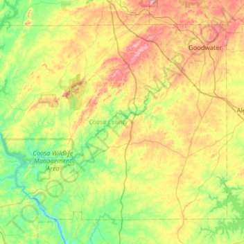
Name: Coosa County topographic map, elevation, terrain.
Location: Coosa County, Alabama, United States (32.75349 -86.52147 33.10486 -85.99930)
Average elevation: 633 ft
Minimum elevation: 262 ft
Maximum elevation: 1,319 ft
Alabama trails, hiking, mountain biking, running and outdoor activities
Other topographic maps
Click on a map to view its topography, its elevation and its terrain.
Gulf Shores
United States > Alabama > Gulf Shores
Jack Edwards National Airport is located in Gulf Shores and offers services from Gulf Air Center, Salt Air Aviation Center and Platium Air Center. The airport is located in town, two miles from the beach. Their FBO Gulf Air Center will provide a rental vehicle while they take care of fueling and storing…
Average elevation: 20 ft
Ono Island
United States > Alabama > Baldwin County
Ono Island was along the boundary of the treaties between France and Spain. In 1813, after protests and attempts at rebellion, President James Monroe seized Spanish lands west of the Perdido River and declared them a part of the Louisiana Purchase of 1803. This set the east end of the Island, Perdido Key, at…
Average elevation: 3 ft
Biltmore Estates
United States > Alabama > Jefferson County > Vestavia Hills
Average elevation: 810 ft
Cheaha Mountain
United States > Alabama > Cleburne County
Cheaha Mountain is part of the Talladega Mountains, a small section of the Ridge and Valley Mountains, unlike other elevations of the Appalachians in north Alabama, which are part of the Cumberland Plateau. The mountain is the highest point in the eastern portion of the Sun Belt (east of the Mississippi River,…
Average elevation: 1,781 ft