
Make a donation
Gear up for your next adventure:
As an Amazon Associate, this site earns from qualifying purchases at no extra cost to you.
Zürich topographic map
Click on the map to display elevation.
Make a donation
Gear up for your next adventure:
As an Amazon Associate, this site earns from qualifying purchases at no extra cost to you.
Zürich
Der Kanton Zürich hatte 2015 einen höheren Index der menschlichen Entwicklung als jeder unabhängige Staat der Erde und jede andere substaatliche Region, vom Australian Capital Territory abgesehen.
Make a donation
Gear up for your next adventure:
As an Amazon Associate, this site earns from qualifying purchases at no extra cost to you.
About this map
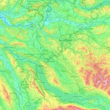
Name: Zürich topographic map, elevation, terrain.
Location: Zürich, Schweiz (47.15944 8.35768 47.69447 8.98494)
Average elevation: 1,752 ft
Minimum elevation: 1,040 ft
Maximum elevation: 4,298 ft
Make a donation
Gear up for your next adventure:
As an Amazon Associate, this site earns from qualifying purchases at no extra cost to you.
Other topographic maps
Click on a map to view its topography, its elevation and its terrain.
Effretikon
Schweiz > Zürich > Bezirk Pfäffikon > Illnau-Effretikon > Effretikon
Average elevation: 1,732 ft
Make a donation
Gear up for your next adventure:
As an Amazon Associate, this site earns from qualifying purchases at no extra cost to you.
Make a donation
Gear up for your next adventure:
As an Amazon Associate, this site earns from qualifying purchases at no extra cost to you.
Make a donation
Gear up for your next adventure:
As an Amazon Associate, this site earns from qualifying purchases at no extra cost to you.
Lägern
Schweiz > Zürich > Bezirk Dielsdorf > Boppelsen
Flugaufnahme des bewaldeten Höhenrückens (1963)
Average elevation: 2,028 ft
Make a donation
Gear up for your next adventure:
As an Amazon Associate, this site earns from qualifying purchases at no extra cost to you.
Make a donation
Gear up for your next adventure:
As an Amazon Associate, this site earns from qualifying purchases at no extra cost to you.
Make a donation
Gear up for your next adventure:
As an Amazon Associate, this site earns from qualifying purchases at no extra cost to you.
Oberkempttal
Schweiz > Zürich > Bezirk Pfäffikon > Illnau-Effretikon > Ottikon
Average elevation: 1,804 ft
Make a donation
Gear up for your next adventure:
As an Amazon Associate, this site earns from qualifying purchases at no extra cost to you.
Make a donation
Gear up for your next adventure:
As an Amazon Associate, this site earns from qualifying purchases at no extra cost to you.
Uetliberg
Schweiz > Zürich > Bezirk Affoltern > Stallikon
Der Uetliberg bietet – vor allem von dem auf dem Berggipfel gelegenen Aussichtsturm Uetliberg aus – Aussicht über die ganze Stadt und den Zürichsee. Die Fernsicht erstreckt sich bei guter Witterung im Norden bis zum Hohentwiel, vom Osten bis Süden in die Glarner, Bündner und Berner Alpen. Weitere…
Average elevation: 2,047 ft
Bachtel
Schweiz > Zürich > Bezirk Hinwil > Hinwil
Südöstlich, unterhalb des Gipfels, liegt auf ca. 955 Meter Höhe der Bachtelspalt . Es handelt sich um eine Spalte, die 1939 beim Abrutschen eines NagelfluhKopfes entstand. Sie ist begehbar, aber sehr eng.
Average elevation: 2,848 ft
Make a donation
Gear up for your next adventure:
As an Amazon Associate, this site earns from qualifying purchases at no extra cost to you.
Obere Schwanden
Schweiz > Zürich > Bezirk Horgen > Richterswil > Samstagern > Obere Schwanden
Average elevation: 1,890 ft
Make a donation
Gear up for your next adventure:
As an Amazon Associate, this site earns from qualifying purchases at no extra cost to you.
Make a donation
Gear up for your next adventure:
As an Amazon Associate, this site earns from qualifying purchases at no extra cost to you.
Jonenbach-Wasserfall
Schweiz > Zürich > Bezirk Affoltern > Affoltern am Albis
Average elevation: 1,818 ft