
Mount Wellington topographic map
Interactive map
Click on the map to display elevation.
About this map
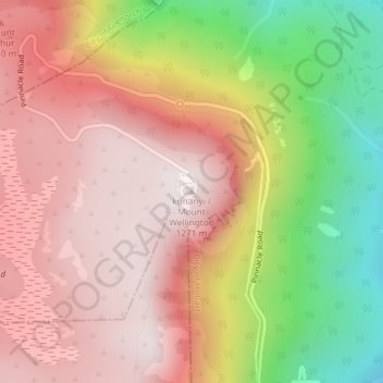
Name: Mount Wellington topographic map, elevation, terrain.
Location: Mount Wellington, City of Hobart, Tasmania, Australia (-42.89606 147.23726 -42.89596 147.23736)
Average elevation: 3,087 ft
Minimum elevation: 1,453 ft
Maximum elevation: 4,144 ft
"... In many parts the Eucalypti grew to a great size, and composed a noble forest. In some of the dampest ravines, tree-ferns flourished in an extraordinary manner; I saw one which must have been at least twenty feet high to the base of the fronds, and was in girth exactly six feet. The fronds forming the most elegant parasols, produced a gloomy shade, like that of the first hour of the night. The summit of the mountain is broad and flat, and is composed of huge angular masses of naked greenstone. Its elevation is 3,100 feet [940 m] above the level of the sea. The day was splendidly clear, and we enjoyed a most extensive view; to the north, the country appeared a mass of wooded mountains, of about the same height with that on which we were standing, and with an equally tame outline: to the south the broken land and water, forming many intricate bays, was mapped with clearness before us. ..."
Other topographic maps
Click on a map to view its topography, its elevation and its terrain.
Lake St Clair
Lake St Clair, Central Highlands, Tasmania, Australia
Average elevation: 2,982 ft
Lake Louise
Lake Louise, Grindelwald, West Tamar, Tasmania, Australia
Average elevation: 407 ft
Garden Island
Garden Island, Huon Valley, Tasmania, Australia
Average elevation: 30 ft
Mole Creek
Mole Creek, Meander Valley, Tasmania, 7304, Australia
Average elevation: 1,444 ft
Launceston
Launceston, City of Launceston, Tasmania, Australia
Average elevation: 636 ft
Mount Field
Mount Field, Derwent Valley, Tasmania, 7140, Australia
Average elevation: 2,362 ft
Lake Margaret
Australia > Tasmania > Lake Margaret
Lake Margaret, West Coast, Tasmania, Australia
Average elevation: 2,497 ft
Bream Creek
Australia > Tasmania > Bream Creek
Bream Creek, Sorell, Tasmania, Australia
Average elevation: 115 ft
Cradle Mountain
Cradle Mountain, Kentish, Tasmania, Australia
Average elevation: 2,493 ft
Binalong Bay
Binalong Bay, Break O'Day, Tasmania, Australia
Average elevation: 102 ft
Great Lake
Great Lake, Central Highlands, Tasmania, Australia
Average elevation: 3,593 ft
Strathgordon
Strathgordon, Derwent Valley, Tasmania, 7139, Australia
Average elevation: 1,273 ft
South Bruny
South Bruny, Kingborough, Tasmania, Australia
Average elevation: 154 ft
North Scottsdale
North Scottsdale, Dorset, Tasmania, 7260, Australia
Average elevation: 338 ft
Prospect Vale
Australia > Tasmania > Launceston
Prospect Vale, Launceston, Meander Valley, Tasmania, 7250, Australia
Average elevation: 571 ft
Mount Tyndall
Mount Tyndall, West Coast, Tasmania, Australia
Average elevation: 2,986 ft
Beauty Point
Beauty Point, West Tamar, Tasmania, Australia
Average elevation: 66 ft
West Gawler River
Australia > Tasmania > Sprent > Gawler
West Gawler River, Gawler, Sprent, Central Coast, Tasmania, Australia
Average elevation: 659 ft
Wellington Park
Wellington Park, Derwent Valley, Tasmania, 7054, Australia
Average elevation: 1,375 ft
Mount Ossa
Mount Ossa, Meander Valley, Tasmania, Australia
Average elevation: 3,996 ft
Walls Of Jerusalem
Walls Of Jerusalem, Tasmania, Australia
Average elevation: 4,213 ft
Roger River
Australia > Tasmania > Roger River
Roger River, Circular Head, Tasmania, Australia
Average elevation: 430 ft
Goose Island
Goose Island, Flinders Council, Tasmania, Australia
Average elevation: 3 ft