
Make a donation
Gear up for your next adventure:
As an Amazon Associate, this site earns from qualifying purchases at no extra cost to you.
Lazio topographic map
Click on the map to display elevation.
Make a donation
Gear up for your next adventure:
As an Amazon Associate, this site earns from qualifying purchases at no extra cost to you.
About this map
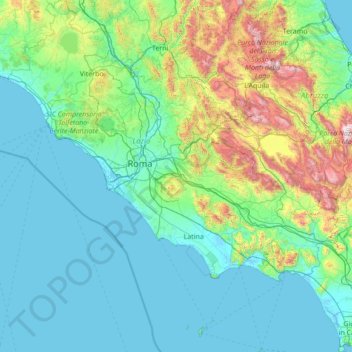
Name: Lazio topographic map, elevation, terrain.
Location: Lazio, Italy (40.78493 11.44917 42.83873 14.02764)
Average elevation: 1,099 ft
Minimum elevation: -10 ft
Maximum elevation: 8,924 ft
Make a donation
Gear up for your next adventure:
As an Amazon Associate, this site earns from qualifying purchases at no extra cost to you.
Other topographic maps
Click on a map to view its topography, its elevation and its terrain.
Rome
Italy > Lazio > Roma Capitale
Although the city centre is about 24 km (15 mi) inland from the Tyrrhenian Sea, the city territory extends to the shore, where the south-western district of Ostia is located. The altitude of the central part of Rome ranges from 13 m (43 ft) above sea level (at the base of the Pantheon) to 139 m (456 ft) above…
Average elevation: 256 ft
Apennine Mountains
A separate branch, the Apuan Alps, goes southwest, bordering the coast south of La Spezia. Whether they are to be considered part of the Apennines is a matter of opinion; certainly, they are part of the Apennine System. Topographically only the valley of the River Serchio, which running parallel to the coast…
Average elevation: 5,692 ft
Naples
Italy > Campania > Napoli > Naples
The city is situated on the Gulf of Naples, on the western coast of southern Italy; it rises from sea level to an elevation of 450 metres (1,480 ft). The small rivers which formerly crossed the centre of the city have since been covered over by construction. It lies between two notable volcanic regions, Mount…
Average elevation: 190 ft
Monte Cassino
Italy > Lazio > Frosinone > Cassino
Monte Cassino (today usually spelled Montecassino) is a rocky hill about 130 kilometres (80 mi) southeast of Rome, in the Latin Valley, Italy, 2 kilometres (1+1⁄4 mi) west of Cassino and at an elevation of 520 m (1,710 ft). Site of the Roman town of Casinum, it is widely known for its abbey, the first house…
Average elevation: 758 ft
Make a donation
Gear up for your next adventure:
As an Amazon Associate, this site earns from qualifying purchases at no extra cost to you.
Matterhorn
Italy > Aosta Valley > Valtournenche
In 1999, the summit height was precisely determined to be at 4,477.54 m (14,690 ft) above sea level by using Global Positioning System technology as part of the TOWER Project (Top of the World Elevations Remeasurement) and to an accuracy of less than one centimetre, which allows future changes to be tracked.
Average elevation: 10,810 ft
Mount Etna
During the first 1500 years AD, many eruptions went unrecorded (or records have been lost); among the more significant are: (1) an eruption in about 1030 AD near Monte Ilice on the lower southeast flank, which produced a lava flow that travelled about 10 km, reaching the sea north of Acireale; the villages of…
Average elevation: 3,796 ft
Make a donation
Gear up for your next adventure:
As an Amazon Associate, this site earns from qualifying purchases at no extra cost to you.
Matterhorn
Italy > Aosta Valley > Valtournenche
In 1999, the summit height was precisely determined to be at 4,477.54 m (14,690 ft) above sea level by using Global Positioning System technology as part of the TOWER Project (Top of the World Elevations Remeasurement) and to an accuracy of less than one centimetre, which allows future changes to be tracked.
Average elevation: 10,810 ft
Le Breuil - Cervinia
The ski area is very large and guarantees good snow quality during the season, being at a high altitude (2,050 m to 3,500 m).
Average elevation: 7,795 ft
Make a donation
Gear up for your next adventure:
As an Amazon Associate, this site earns from qualifying purchases at no extra cost to you.
Secëda - Monte Seceda
Italy > Trentino – Alto Adige/Südtirol > South Tyrol > Santa Cristina Gherdëina - St. Christina in Gröden - Santa Cristina Valgardena
Monte Seceda is a 2,519-meter-elevation (8,264-foot) summit in the Odles Group of the Dolomites, a UNESCO World Heritage Site. Set in the Trentino-Alto Adige/Südtirol region, the peak is located four kilometers (2.5 miles) north of the village of Santa Cristina Gherdëina, and the peak is in Puez-Geisler…
Average elevation: 6,909 ft
Make a donation
Gear up for your next adventure:
As an Amazon Associate, this site earns from qualifying purchases at no extra cost to you.
Gherdëina - Grödnertal - Val Gardena
Italy > Trentino – Alto Adige/Südtirol > South Tyrol > Urtijëi - St. Ulrich in Gröden - Ortisei
Average elevation: 5,272 ft
Make a donation
Gear up for your next adventure:
As an Amazon Associate, this site earns from qualifying purchases at no extra cost to you.
Make a donation
Gear up for your next adventure:
As an Amazon Associate, this site earns from qualifying purchases at no extra cost to you.
Mount Vesuvius
Italy > Campania > Naples > Trecase
The volcano's slopes are scarred by lava flows, while the rest are heavily vegetated, with scrub and forests at higher altitudes and vineyards lower down.
Average elevation: 2,828 ft
Mount Vesuvius
Italy > Campania > Naples > Trecase
The volcano's slopes are scarred by lava flows, while the rest are heavily vegetated, with scrub and forests at higher altitudes and vineyards lower down.
Average elevation: 2,828 ft
Make a donation
Gear up for your next adventure:
As an Amazon Associate, this site earns from qualifying purchases at no extra cost to you.
Etna
Italy > Sicily > Catania > Zafferana Etnea
Eruptions of Etna follow multiple patterns. Most occur at the summit, where there are five distinct craters: the Northeast Crater, the Voragine, the Bocca Nuova, and two at the Southeast Crater Complex. Other eruptions occur on the flanks, which have more than 300 vents ranging in size from small holes in the…
Average elevation: 9,764 ft
Make a donation
Gear up for your next adventure:
As an Amazon Associate, this site earns from qualifying purchases at no extra cost to you.
Welsberg - Monguelfo
Italy > Trentino – Alto Adige/Südtirol > South Tyrol > Welsberg-Taisten - Monguelfo-Tesido
Average elevation: 4,229 ft
Make a donation
Gear up for your next adventure:
As an Amazon Associate, this site earns from qualifying purchases at no extra cost to you.
Monviso
Italy > Piedmont > Cuneo > Pontechianale
Monte Viso is the location of a neolithic jadeite quarry, at an elevation of 2000 to 2400 metres. Its productivity peaked around 5000 BC. The jadeite was used to make cult axes, which are found all over western Europe. One such ceremonial axe head was found as far away as a small hill called Tristia in Western…
Average elevation: 9,793 ft
Make a donation
Gear up for your next adventure:
As an Amazon Associate, this site earns from qualifying purchases at no extra cost to you.
Palatine Hill
Italy > Lazio > Roma Capitale > Rome
In 2007 the legendary Lupercal cave was claimed to have been found beneath the remains of the Domus Livia (House of Livia) on the Palatine. Archaeologists came across the 16-metre-deep cavity while restoring the decaying palace, with a richly decorated vault encrusted with mosaics and seashells. The Lupercal…
Average elevation: 131 ft
Make a donation
Gear up for your next adventure:
As an Amazon Associate, this site earns from qualifying purchases at no extra cost to you.
Albana / Ibána / Albane
Italy > Friuli – Venezia Giulia > Udine / Udin / Videm > Prepotto / Prapotno / Prepot
Average elevation: 574 ft
Make a donation
Gear up for your next adventure:
As an Amazon Associate, this site earns from qualifying purchases at no extra cost to you.
Compatsch
Italy > Trentino-Alto Adige/Südtirol > South Tyrol > Kastelruth - Castelrotto
Average elevation: 6,099 ft
Matterhorn
Italy > Aosta Valley > Valtournenche
In 1999, the summit height was precisely determined to be at 4,477.54 m (14,690 ft) above sea level by using Global Positioning System technology as part of the TOWER Project (Top of the World Elevations Remeasurement) and to an accuracy of less than one centimetre, which allows future changes to be tracked.
Average elevation: 10,810 ft
Make a donation
Gear up for your next adventure:
As an Amazon Associate, this site earns from qualifying purchases at no extra cost to you.
Tribil Superiore / Gorenji Tarbij
Italy > Friuli – Venezia Giulia > Udine > Stregna
Average elevation: 1,640 ft
Monte Cengio
Italy > Veneto > Vicenza > Cogollo del Cengio
Monte Cengio is a mountain in the Asiago plateau, within the Vicentine Alps, in Veneto, northeastern Italy. It has an elevation of 1,354 metres and is located on the southwestern edge of the plateau, in the territory of Cogollo del Cengio.
Average elevation: 3,068 ft
Make a donation
Gear up for your next adventure:
As an Amazon Associate, this site earns from qualifying purchases at no extra cost to you.
Croce di Envie - Cima Bracco
Italy > Piedmont > Cuneo > Sanfront
The Monte Bracco (though the name is sometimes shortened to Mombracco) is a mountain in the Cottian Alps with an elevation of 1,307 meters above sea level. It is located between the Valle Po, the Valle Infernotto [it], and the Cuneo plain.
Average elevation: 3,107 ft
Monte Bregagno
Italy > Lombardy > Como > Cremia
Monte Bregagno is a mountain of Lombardy, Italy, It has an elevation of 2,107 metres.
Average elevation: 5,538 ft
Make a donation
Gear up for your next adventure:
As an Amazon Associate, this site earns from qualifying purchases at no extra cost to you.
Make a donation
Gear up for your next adventure:
As an Amazon Associate, this site earns from qualifying purchases at no extra cost to you.
Gufidaun - Gudon
Italy > Trentino – Alto Adige/Südtirol > South Tyrol > Klausen - Chiusa
Average elevation: 2,822 ft
Make a donation
Gear up for your next adventure:
As an Amazon Associate, this site earns from qualifying purchases at no extra cost to you.
Make a donation
Gear up for your next adventure:
As an Amazon Associate, this site earns from qualifying purchases at no extra cost to you.
Parco archeologico di Castel Seprio
Italy > Lombardy > Varese > Castelseprio > Vico Seprio
Average elevation: 1,030 ft
Sulden - Solda
Italy > Trentino – Alto Adige/Südtirol > South Tyrol > Stilfs - Stelvio
Average elevation: 7,323 ft
Make a donation
Gear up for your next adventure:
As an Amazon Associate, this site earns from qualifying purchases at no extra cost to you.
Monviso
Italy > Piedmont > Cuneo > Pontechianale
Monte Viso is the location of a Neolithic jadeite quarry, at an elevation of 2,000 to 2,400 metres. Its productivity peaked around 5000 BC. The jadeite was used to make cult axes, which are found all over western Europe. One such ceremonial axe head was found as far away as a small hill called Tristia in…
Average elevation: 9,793 ft
Make a donation
Gear up for your next adventure:
As an Amazon Associate, this site earns from qualifying purchases at no extra cost to you.
Make a donation
Gear up for your next adventure:
As an Amazon Associate, this site earns from qualifying purchases at no extra cost to you.
Make a donation
Gear up for your next adventure:
As an Amazon Associate, this site earns from qualifying purchases at no extra cost to you.
Make a donation
Gear up for your next adventure:
As an Amazon Associate, this site earns from qualifying purchases at no extra cost to you.
Gran Paradiso
Italy > Aosta Valley > Valsavarenche
The peak is the 7th highest mountain in the Graian Alps, with an elevation of 4,061 m. In the SOIUSA (International Standardized Mountain Subdivision of the Alps) the mountain belongs to an alpine subsection called "North-Eastern Graian Alps" (It:Alpi del Gran Paradiso; Fr:Alpes du Grand-Paradis) and also…
Average elevation: 11,348 ft
Make a donation
Gear up for your next adventure:
As an Amazon Associate, this site earns from qualifying purchases at no extra cost to you.
Make a donation
Gear up for your next adventure:
As an Amazon Associate, this site earns from qualifying purchases at no extra cost to you.