
Make a donation
Gear up for your next adventure:
As an Amazon Associate, this site earns from qualifying purchases at no extra cost to you.
Morogoro Region topographic map
Click on the map to display elevation.
Make a donation
Gear up for your next adventure:
As an Amazon Associate, this site earns from qualifying purchases at no extra cost to you.
Morogoro Region
The Morogoro region has a total size of 73,039 square kilometers, which is split between land (70,967 square kilometers, or 97.2 percent of the total area), and water (2,073 km2 or 2.8 percent). As of 2012, Ulanga District is the largest district,Malinyi DC comes in second with 17.0 percent of the region's total land area, followed by Morogoro DC with 16.1 percent. Kilosa District comes in first with 18.6 percent. Morogoro Municipal was the district with the smallest land size (531 km2 or 10.7%), followed by Gairo DC with (1,851 km2 or 2.5 percent). Different scenarios exist in Kilosa DC, Malinyi DC, Ifakara TC, Ulanga DC, Morogoro MC, and Gairo DC, with all of their respective territories being completely covered by land. While Mvomero DC (1,882 km2) has the most water area in the area. At Mlimba DC, there is the smallest water area (70 km2). According to topographical and ecological zones, the region's soils differ.
Make a donation
Gear up for your next adventure:
As an Amazon Associate, this site earns from qualifying purchases at no extra cost to you.
About this map
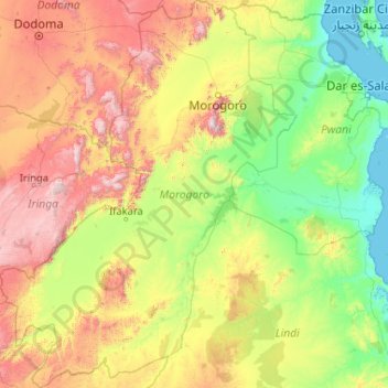
Name: Morogoro Region topographic map, elevation, terrain.
Location: Morogoro Region, Coastal Zone, Tanzania (-9.92346 35.32406 -5.80227 38.51660)
Average elevation: 1,768 ft
Minimum elevation: 0 ft
Maximum elevation: 8,399 ft
Make a donation
Gear up for your next adventure:
As an Amazon Associate, this site earns from qualifying purchases at no extra cost to you.
Other topographic maps
Click on a map to view its topography, its elevation and its terrain.
Mbeya
Mbeya is situated at an altitude of 1,700 metres (5,500 ft), and sprawls through a narrow highland valley surrounded by a bowl of high mountains. The main language is colloquial Swahili, and the English language is extensively taught in schools.
Average elevation: 5,961 ft
Arusha
Despite its proximity to the equator, Arusha's elevation of 1,400 metres (4,600 ft) on the southern slopes of Mount Meru keeps temperatures relatively low and alleviates humidity. Cool dry air is prevalent for much of the year. The temperature typically ranges between 10 and 30 °C (50 and 86 °F) with an…
Average elevation: 5,157 ft
Kilimanjaro
Mount Kilimanjaro (/ˌkɪlɪmənˈdʒɑːroʊ/) is a dormant volcano in Tanzania. It is the highest mountain in Africa and the highest free-standing mountain above sea level in the world: 5,895 m (19,341 ft) above sea level and 4,900 m (16,100 ft) above its plateau base. It is also the highest volcano in the…
Average elevation: 5,043 ft
Make a donation
Gear up for your next adventure:
As an Amazon Associate, this site earns from qualifying purchases at no extra cost to you.
Make a donation
Gear up for your next adventure:
As an Amazon Associate, this site earns from qualifying purchases at no extra cost to you.
Make a donation
Gear up for your next adventure:
As an Amazon Associate, this site earns from qualifying purchases at no extra cost to you.
Make a donation
Gear up for your next adventure:
As an Amazon Associate, this site earns from qualifying purchases at no extra cost to you.
Make a donation
Gear up for your next adventure:
As an Amazon Associate, this site earns from qualifying purchases at no extra cost to you.
Lake Chala
Lake Chala's average annual rainfall is about 565 millimetres (22.2 in). The lake surface has an average annual evaporation of near 1,735 millimetres (68.3 in). Approximately 80 percent of the lake's inflow comes from groundwater, which is derived mostly from rainfall in the montane forest zone of Mount…
Average elevation: 2,953 ft
Mbeya
Mbeya is situated at an altitude of 1,700 metres (5,500 ft), and sprawls through a narrow highland valley surrounded by a bowl of high mountains. The main language is colloquial Swahili, and the English language is extensively taught in schools.
Average elevation: 5,961 ft
Make a donation
Gear up for your next adventure:
As an Amazon Associate, this site earns from qualifying purchases at no extra cost to you.
Make a donation
Gear up for your next adventure:
As an Amazon Associate, this site earns from qualifying purchases at no extra cost to you.
Make a donation
Gear up for your next adventure:
As an Amazon Associate, this site earns from qualifying purchases at no extra cost to you.
Mutukula
The town of Mutukula is a border town between Uganda and Tanzania. At an altitude of 1,190 metres (3,900 ft), above sea level, Mutukula is an important border post and major crossing point, for both human and commercial traffic. In February 2016, the border post between both countries merged operations on both…
Average elevation: 3,875 ft
Make a donation
Gear up for your next adventure:
As an Amazon Associate, this site earns from qualifying purchases at no extra cost to you.
Kilimanjaro
Kilimanjaro is the fourth most topographically prominent peak on Earth. It is part of Kilimanjaro National Park and is a major hiking and climbing destination. Because of its shrinking glaciers and ice fields, which are projected to disappear between 2025 and 2035, it has been the subject of many scientific…
Average elevation: 5,043 ft
Make a donation
Gear up for your next adventure:
As an Amazon Associate, this site earns from qualifying purchases at no extra cost to you.
Make a donation
Gear up for your next adventure:
As an Amazon Associate, this site earns from qualifying purchases at no extra cost to you.
Make a donation
Gear up for your next adventure:
As an Amazon Associate, this site earns from qualifying purchases at no extra cost to you.
Make a donation
Gear up for your next adventure:
As an Amazon Associate, this site earns from qualifying purchases at no extra cost to you.
Make a donation
Gear up for your next adventure:
As an Amazon Associate, this site earns from qualifying purchases at no extra cost to you.
Kilimanjaro
Mount Kilimanjaro (/ˌkɪlɪmənˈdʒɑːroʊ/) is a dormant volcano in Tanzania. It is the highest mountain in Africa and the highest free-standing mountain above sea level in the world, at 5,895 m (19,341 ft) above sea level and 4,900 m (16,100 ft) above its plateau base. It is also the highest volcano in…
Average elevation: 5,043 ft
Make a donation
Gear up for your next adventure:
As an Amazon Associate, this site earns from qualifying purchases at no extra cost to you.
Make a donation
Gear up for your next adventure:
As an Amazon Associate, this site earns from qualifying purchases at no extra cost to you.
Make a donation
Gear up for your next adventure:
As an Amazon Associate, this site earns from qualifying purchases at no extra cost to you.
Make a donation
Gear up for your next adventure:
As an Amazon Associate, this site earns from qualifying purchases at no extra cost to you.
Make a donation
Gear up for your next adventure:
As an Amazon Associate, this site earns from qualifying purchases at no extra cost to you.
Kilimanjaro
Kilimanjaro is the fourth most topographically prominent peak on Earth. It is part of Kilimanjaro National Park and is a major hiking and climbing destination. Because of its shrinking glaciers and ice fields, which are projected to disappear between 2025 and 2035, it has been the subject of many scientific…
Average elevation: 5,043 ft
Make a donation
Gear up for your next adventure:
As an Amazon Associate, this site earns from qualifying purchases at no extra cost to you.
Make a donation
Gear up for your next adventure:
As an Amazon Associate, this site earns from qualifying purchases at no extra cost to you.
Kilimanjaro
Mount Kilimanjaro (/ˌkɪlɪmənˈdʒɑːroʊ/) is a dormant volcano in Tanzania. It is the highest mountain in Africa and the highest free-standing mountain above sea level in the world, situated at 5,895 m (19,341 ft) above sea level and 4,900 m (16,100 ft) above its plateau base. It is also the highest…
Average elevation: 5,043 ft
Make a donation
Gear up for your next adventure:
As an Amazon Associate, this site earns from qualifying purchases at no extra cost to you.
Make a donation
Gear up for your next adventure:
As an Amazon Associate, this site earns from qualifying purchases at no extra cost to you.
Make a donation
Gear up for your next adventure:
As an Amazon Associate, this site earns from qualifying purchases at no extra cost to you.