
Make a donation
Gear up for your next adventure:
As an Amazon Associate, this site earns from qualifying purchases at no extra cost to you.
Research Triangle topographic map
Click on the map to display elevation.
Make a donation
Gear up for your next adventure:
As an Amazon Associate, this site earns from qualifying purchases at no extra cost to you.
About this map
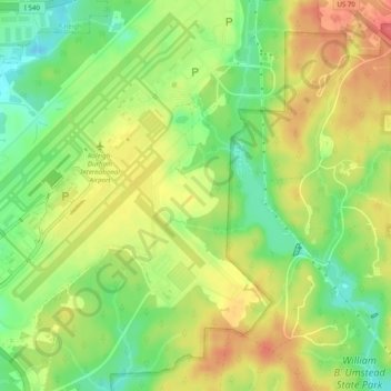
Name: Research Triangle topographic map, elevation, terrain.
Average elevation: 377 ft
Minimum elevation: 20 ft
Maximum elevation: 1,762 ft
Make a donation
Gear up for your next adventure:
As an Amazon Associate, this site earns from qualifying purchases at no extra cost to you.
Other topographic maps
Click on a map to view its topography, its elevation and its terrain.
Charlotte
United States > North Carolina > Mecklenburg County
According to the United States Census Bureau, the city has a total area of 308.6 square miles (799 km2), of which 306.6 square miles (794 km2) is land and 2.0 square miles (5.2 km2) is water. Charlotte is the twenty-sixth-most expansive city in the United States and lies at an elevation of 751 feet (229 m).…
Average elevation: 679 ft
Raleigh
United States > North Carolina > Wake County
Raleigh features a topography primarily defined by its position along the fall line, which is the geological boundary between the Piedmont and Coastal Plain regions. This area experiences a gradual elevation drop of approximately 150 to 350 feet over a distance of 1 to 3 miles as one moves eastward. The city's…
Average elevation: 338 ft
Asheville
United States > North Carolina > Buncombe County
Asheville, located in Buncombe County, North Carolina, is characterized by a diverse and picturesque topography primarily shaped by its position within the Blue Ridge Mountains. The city itself sits at an elevation of approximately 2,200 feet, surrounded by peaks that rise significantly higher, such as Mount…
Average elevation: 2,385 ft
Wilkes County
United States > North Carolina
Wilkes County is located on the eastern slope of the Blue Ridge Mountains, a part of the Appalachian Mountains chain. The county's elevation ranges from 900 feet (375 meters) in the east to over 4,000 feet (1,219 meters) in the west. The Blue Ridge Mountains run from the southwest to the northeast, and…
Average elevation: 1,683 ft
Make a donation
Gear up for your next adventure:
As an Amazon Associate, this site earns from qualifying purchases at no extra cost to you.
Charlotte
United States > North Carolina > Mecklenburg County
Charlotte, located in the Piedmont region of North Carolina, features a gently rolling terrain characterized by elevations ranging from approximately 650 to 700 feet (198 to 213 meters). The city is bordered to the west by the Catawba River, which contributes to the area's mild climate and lush vegetation.…
Average elevation: 679 ft
Wilmington
United States > North Carolina > New Hanover County
Wilmington sits near the southeastern coast and has a low-lying, relatively flat topography with an average elevation around 36 feet above sea level. The terrain is characterized by coastal plains with minimal elevation changes, making the landscape generally flat as it gently slopes toward the Atlantic Ocean.…
Average elevation: 23 ft
Make a donation
Gear up for your next adventure:
As an Amazon Associate, this site earns from qualifying purchases at no extra cost to you.
Watauga County
United States > North Carolina
Watauga County is extremely mountainous, and all of the county's terrain is located within the Appalachian Mountains range. The highest point in the county is Calloway Peak, the highest peak of Grandfather Mountain (shared with the adjacent counties of Avery and Caldwell), which rises to 5,964 feet (1,818…
Average elevation: 3,228 ft
Avery County
United States > North Carolina
Avery County showcases a strikingly rugged topography characterized by its placement within the Appalachian Mountains. This mountainous terrain features elevations averaging about 3,500 feet, making it one of the highest counties east of the Mississippi River. The highest peak in the county is Grassy Ridge…
Average elevation: 3,301 ft
Blue Ridge Parkway
United States > North Carolina > Watauga County
The parkway has been the most visited unit of the National Park System every year since 1946 except four (1949, 2013, 2016 and 2019).[4][5] Land on either side of the road is owned and maintained by the National Park Service, and in many places parkway land is bordered by United States Forest Service property.…
Average elevation: 1,654 ft
Make a donation
Gear up for your next adventure:
As an Amazon Associate, this site earns from qualifying purchases at no extra cost to you.
Greensboro
United States > North Carolina > Guilford County
Greensboro is characterized by a gently rolling topography, typical of the Piedmont region. The city sits at an elevation of approximately 790 feet (241 meters) above sea level, with its terrain featuring a mix of low hills and valleys that create a varied landscape. The area is bisected by several waterways,…
Average elevation: 794 ft
Blowing Rock
United States > North Carolina > Watauga County
Blowing Rock is characterized by its rugged and varied topography, nestled within the southern reaches of the Blue Ridge Mountains. The town itself is situated on a prominent ridge, with elevations ranging from approximately 3,300 to 3,600 feet, creating dramatic landscapes that feature steep slopes, rocky…
Average elevation: 3,386 ft
Watauga County
United States > North Carolina
Watauga County is extremely mountainous, and all of the county's terrain is located within the Appalachian Mountains range. The highest point in the county is Calloway Peak, the highest peak of Grandfather Mountain (shared with the adjacent counties of Avery and Caldwell), which rises to 5,964 feet (1,818…
Average elevation: 3,228 ft
Make a donation
Gear up for your next adventure:
As an Amazon Associate, this site earns from qualifying purchases at no extra cost to you.
Make a donation
Gear up for your next adventure:
As an Amazon Associate, this site earns from qualifying purchases at no extra cost to you.
Franklin County
United States > North Carolina
Franklin County exhibits a diverse topography characterized primarily by gently rolling hills and low-lying areas interspersed with valleys and water bodies. The county's elevation varies, with the highest points reaching approximately 600 feet above sea level, while much of the landscape sits around 300 to…
Average elevation: 302 ft
Banner Elk
United States > North Carolina > Avery County
Banner Elk is nestled within the Blue Ridge Mountains, characterized by rugged and varied terrain. The town itself sits at an elevation of around 3,700 feet, offering expansive views of the surrounding peaks and valleys. This region, part of the southern Appalachian range, includes steep slopes, dense forests,…
Average elevation: 3,822 ft
Gaston County
United States > North Carolina
Crowders Mountain State Park is the largest natural heritage site in the county. It covers over 3,000 acres (12 km2) of topographically, botanically, and zoologically diverse land. Six natural plant communities are found in the park, and the area supports a diversity of wildlife species. Some animals…
Average elevation: 774 ft
Make a donation
Gear up for your next adventure:
As an Amazon Associate, this site earns from qualifying purchases at no extra cost to you.
Make a donation
Gear up for your next adventure:
As an Amazon Associate, this site earns from qualifying purchases at no extra cost to you.
Boone
United States > North Carolina > Watauga County
Boone, located in Watauga County, North Carolina, is set within the rugged Appalachian Mountains, specifically the Blue Ridge range. With an elevation of approximately 3,300 feet (1,016 meters), it stands as one of the highest towns of its size in the eastern United States. The terrain is dominated by steep…
Average elevation: 3,507 ft
Cary
United States > North Carolina > Wake County
Cary is seated on the boundary between the Durham Basin with its softer sedimentary rocks and the piedmont with its harder metamorphic rocks; both geologic provinces have igneous rock intrusions. The landscape is typically gentle to moderate sloping hills separated by narrow V-shaped valleys, but there are…
Average elevation: 364 ft
Tryon
United States > North Carolina > Polk County
The elevation of the town is 1,067 feet (325 m) above sea level. The town's original boundary was established as a circle with a radius of three quarters of a mile. According to the United States Census Bureau, the town has a total area of 1.8 square miles (4.7 km2), all land.
Average elevation: 1,093 ft
Make a donation
Gear up for your next adventure:
As an Amazon Associate, this site earns from qualifying purchases at no extra cost to you.
Wake County
United States > North Carolina
Wake County is located in the northeast central region of North Carolina, where the North American Piedmont and Atlantic Coastal Plain regions meet. This area is known as the "fall line" because it marks the elevation inland at which waterfalls begin to appear in creeks and rivers. As a result, most of Wake…
Average elevation: 315 ft
Make a donation
Gear up for your next adventure:
As an Amazon Associate, this site earns from qualifying purchases at no extra cost to you.
Franklin
United States > North Carolina > Macon County
Franklin is characterized by its mountainous terrain, lying within the picturesque Appalachian Mountains. The area features rugged landscapes with elevations typically ranging from around 2,000 to 4,000 feet, creating dramatic vistas and deep valleys. The Little Tennessee River winds through the region, adding…
Average elevation: 2,215 ft
Make a donation
Gear up for your next adventure:
As an Amazon Associate, this site earns from qualifying purchases at no extra cost to you.
New Bern
United States > North Carolina > Craven County
New Bern exhibits a predominantly flat terrain characterized by low-lying areas near its coastal rivers. The city is strategically positioned at the confluence of the Neuse and Trent rivers, where the elevation averages around 10 to 20 feet (3 to 6 meters) above sea level. This coastal setting contributes…
Average elevation: 16 ft
Ocean Isle Beach
United States > North Carolina > Brunswick County
Ocean Isle Beach is a picturesque barrier island characterized by its low-lying terrain and sandy shorelines. The topography features an average elevation of about 3 feet (1 meter) above sea level, with the landscape gently sloping towards the Atlantic Ocean. The island spans approximately 7 miles in length…
Average elevation: 13 ft
Make a donation
Gear up for your next adventure:
As an Amazon Associate, this site earns from qualifying purchases at no extra cost to you.
Murphy
United States > North Carolina > Cherokee County
Murphy is located in southwestern North Carolina, approximately halfway between Atlanta, Georgia and Knoxville, Tennessee. The topography consists of gentle rolling hills and mountains with tall peaks, including ranges from 1800 ft to more than 5000 ft elevation. The location in the Blue Ridge Mountains has…
Average elevation: 1,686 ft
Cabarrus County
United States > North Carolina
Cabarrus County is situated in the gently rolling countryside of the Carolina Piedmont There are no significantly high peaks or points, although the eastern half of the county contains the westernmost foothills of the Uwharrie Mountains. Altitude ranges from approximately 500–800 feet above sea level. No…
Average elevation: 663 ft
Make a donation
Gear up for your next adventure:
As an Amazon Associate, this site earns from qualifying purchases at no extra cost to you.
Make a donation
Gear up for your next adventure:
As an Amazon Associate, this site earns from qualifying purchases at no extra cost to you.
McDowell County
United States > North Carolina
Archaeological excavations performed by Dr. David Moore during the early 1980s, revealed artifacts and other evidence that the earliest inhabitants of McDowell County lived there from the Woodland period and Mississippian culture era, from 250 to 1500 AD. Dr. Moore discovered this material in an area close to…
Average elevation: 2,238 ft
Mitchell County
United States > North Carolina
Mitchell County is a county located in the U.S. state of North Carolina. As of the 2020 census, the population was 14,903. Its county seat is Bakersville, population 439 (2022), elevation 2470 ft.
Average elevation: 3,235 ft
Make a donation
Gear up for your next adventure:
As an Amazon Associate, this site earns from qualifying purchases at no extra cost to you.
Make a donation
Gear up for your next adventure:
As an Amazon Associate, this site earns from qualifying purchases at no extra cost to you.
Make a donation
Gear up for your next adventure:
As an Amazon Associate, this site earns from qualifying purchases at no extra cost to you.
Carolina Beach
United States > North Carolina > New Hanover County
Carolina Beach is characterized by its relatively flat topography, with elevations averaging around 13 feet above sea level. This coastal town is part of Pleasure Island and features a blend of sandy beaches and salt marshes. The surrounding area includes Carolina Beach State Park, which hosts diverse…
Average elevation: 7 ft
Davidson County
United States > North Carolina
Davidson County is located entirely within the Piedmont region of central North Carolina. The Piedmont consists of gently rolling terrain frequently broken by hills or shallow valleys formed by rivers and streams. An exception to this terrain are the Uwharrie Mountains in the county's western and southwestern…
Average elevation: 728 ft
Make a donation
Gear up for your next adventure:
As an Amazon Associate, this site earns from qualifying purchases at no extra cost to you.
Make a donation
Gear up for your next adventure:
As an Amazon Associate, this site earns from qualifying purchases at no extra cost to you.
Make a donation
Gear up for your next adventure:
As an Amazon Associate, this site earns from qualifying purchases at no extra cost to you.
Wake County
United States > North Carolina
Wake County is located in the northeast central region of North Carolina, where the North American Piedmont and Atlantic Coastal Plain regions meet. This area is known as the "fall line" because it marks the elevation inland at which waterfalls begin to appear in creeks and rivers. As a result, most of Wake…
Average elevation: 315 ft
Transylvania County
United States > North Carolina
Transylvania County is known as the "Land of Waterfalls", due to it having over 250 waterfalls. This is due to a combination of its high precipitation and location on the Blue Ridge Escarpment. Notable waterfalls in the county include Looking Glass Falls, Moore Cove Falls, Rainbow Falls, and Whitewater Falls,…
Average elevation: 2,946 ft
Make a donation
Gear up for your next adventure:
As an Amazon Associate, this site earns from qualifying purchases at no extra cost to you.
Make a donation
Gear up for your next adventure:
As an Amazon Associate, this site earns from qualifying purchases at no extra cost to you.
Swain County
United States > North Carolina
The county is located in far Western North Carolina in the Great Smoky Mountains. It holds more of the Great Smoky Mountains National Park than any other county in North Carolina or Tennessee. The highest point in the county is Clingmans Dome, elevation 6,643 feet, located on the NC/TN border. Clingman's is…
Average elevation: 2,930 ft
Make a donation
Gear up for your next adventure:
As an Amazon Associate, this site earns from qualifying purchases at no extra cost to you.
Nash County
United States > North Carolina
Nash County rests in the northeastern part of North Carolina along the dividing line between the Peidmont and Coastal Plain regions. According to the U.S. Census Bureau, the county has a total area of 542.82 square miles (1,405.9 km2), of which 540.44 square miles (1,399.7 km2) is land and 2.38 square miles…
Average elevation: 194 ft
Haywood County
United States > North Carolina
Haywood County is situated amidst the Blue Ridge Mountains and contains parts of several major subranges of the Blue Ridge, namely the Great Smoky Mountains in the west and the Plott Balsams and Great Balsam Mountains in the south. Notable peaks in the county include Cold Mountain, at 6,030 feet (1,840 m),…
Average elevation: 3,425 ft
Pamlico County
United States > North Carolina
The county was formed in 1872 from parts of Beaufort and Craven counties. It was named for Pamlico Sound, which adjoins it. Vernacular usage in the area, especially in Craven County, refers to Pamlico County as being "down in the county." Prior to 1872, it was a part of Craven County and has a very low…
Average elevation: 16 ft
Make a donation
Gear up for your next adventure:
As an Amazon Associate, this site earns from qualifying purchases at no extra cost to you.
Make a donation
Gear up for your next adventure:
As an Amazon Associate, this site earns from qualifying purchases at no extra cost to you.
Wake Forest
United States > North Carolina > Wake County
Wake Forest is located in the northeast-central region of North Carolina, where the North American Piedmont and Atlantic Coastal Plain regions meet. This area is known as the "Fall Line" because it marks the elevation inland at which waterfalls begin to appear in creeks and rivers. Its central Piedmont…
Average elevation: 344 ft
Make a donation
Gear up for your next adventure:
As an Amazon Associate, this site earns from qualifying purchases at no extra cost to you.