
Krishna River topographic map
Click on the map to display elevation.
Krishna River
The Krishna river originates in the Western Ghats near Mahabaleshwar at an elevation of about 1,300 metres, in the state of Maharashtra in central India. It is one of the longest rivers in India. The Krishna river is around 1,400 km in length (282 KM in Maharashtra). The Krishna river's source is at Mahabaleshwar near the Jor village in the extreme north of Wai Taluka, Satara District, Maharashtra in the west and empties into the Bay of Bengal at Hamasaladeevi (near Koduru) in Andhra Pradesh, on the east coast. It flows through the state of Karnataka before entering Telangana State. The delta of this river is one of the most fertile regions in India and was the home to ancient Satavahana and Ikshvaku Sun Dynasty kings. Vijayawada is the largest city on the River Krishna.
About this map
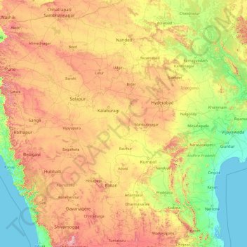
Name: Krishna River topographic map, elevation, terrain.
Location: Krishna River, India (15.71402 73.63803 17.98908 81.13360)
Average elevation: 1,335 ft
Minimum elevation: -3 ft
Maximum elevation: 6,007 ft
Other topographic maps
Click on a map to view its topography, its elevation and its terrain.
Maharashtra
Maharashtra is the third largest state by area in India. The Western Ghats better known as Sahyadri, are a hilly range running parallel to the coast, at an average elevation of 1,200 metres (4,000 ft). Kalsubai, a peak in the Sahyadris, near Nashik city is the highest elevated point in Maharashtra. To the west…
Average elevation: 1,568 ft
Surat
India > Gujarat > Katargam Taluka > Surat
Surat is a port city situated on the banks of the Tapi river. Damming of the Tapi caused the original port facilities to close; the nearest port is now in the Magadalla and Hazira area of Surat Metropolitan Region.It has famous beach called 'Dumas Beach' located in Hazira. The city is located at 21°10′N…
Average elevation: 36 ft
Tirthahalli
India > Karnataka > Tirthahalli taluk
Thirthahalli is located at 13°42′N 75°14′E / 13.7°N 75.23°E / 13.7; 75.23. It has an average elevation of 591 metres (1938 feet). The Tirthahalli Town Panchayat has population of 14,528 of which 7,093 are males while 7,435 are females as per report released by Census India 2011.
Average elevation: 2,083 ft
Valparai
India > Tamil Nadu > Valparai
Valparai is located at 10°22′N 76°58′E / 10.37°N 76.97°E / 10.37; 76.97. It is a mid-elevation hill station (Ootacamund is considerably higher) and has an average elevation of 3,914 feet (1,193 m). It is close to the border with Thrissur district of the Kerala state.
Average elevation: 3,698 ft
Mangaluru
India > Karnataka > Mangaluru taluk
Mangalore is also the administrative headquarters of the Dakshina Kannada district; it is a commercial, industrial, educational, healthcare, and startup hub. The city's international airport is the second-largest and second-busiest airport in Karnataka. Mangalore City Corporation is responsible for the civic…
Average elevation: 82 ft
Visakhapatnam
India > Andhra Pradesh > Visakhapatnam Urban
The city is situated between the Eastern Ghats and the Bay of Bengal. The city coordinates lies between 17.7041 N and 83.2977 E. The city's area is 682 km2. The average elevation is 45 metres. Visakhpatnam is situated in Coastal Andhra Region.
Average elevation: 115 ft
Junagadh
India > Gujarat > Junagadh City Taluka
Junagadh city is located at 21°31′N 70°28′E / 21.52°N 70.47°E / 21.52; 70.47 at the foot of Mount Girnar, with the Arabian sea to the southwest, Porbandar to the north, and Amreli to the east. It has an average elevation of 107 metres (351 ft).
Average elevation: 535 ft
Udaipur
India > Rajasthan > Girwa Tehsil
Udaipur is located at 24°31′30″N 73°40′38″E / 24.525049°N 73.677116°E / 24.525049; 73.677116. The city covers an area of 64 km2 (25 sq mi) and lies at an altitude of 598.00 m (1,962 ft) above sea level. It is located in the southern region of Rajasthan, near the Gujarat border. The city…
Average elevation: 2,152 ft
Varanasi
India > Uttar Pradesh > Sadar
Varanasi is located at an elevation of 80.71 metres (264.8 ft) in the centre of the Ganges valley of North India, in the Eastern part of the state of Uttar Pradesh, along the left crescent-shaped bank of the Ganges, averaging between 15 metres (50 ft) and 21 metres (70 ft) above the river. The city is the…
Average elevation: 253 ft
Kolhapur
India > Maharashtra > Karvir
Kolhapur is an inland city located in south-west Maharashtra state, 373 km (232 mi) south of Mumbai and 228 km (142 mi) south of Pune, 615 km (382 mi) north-west of Bengaluru and 530 km (330 mi) west of Hyderabad. Within Maharashtra, Kolhapur's nearest cities and towns are Ichalkaranji 27 km (17 mi), Kodoli 35…
Average elevation: 1,942 ft
Western Ghats
The range starts near south of the Tapti river and runs approximately 1,600 km (990 mi) through the states of Gujarat, Maharashtra, Karnataka, Goa, Kerala and Tamil Nadu ending at Marunthuvazh Malai near the southern tip of India. These hills cover 160,000 km2 (62,000 sq mi) and form the catchment area for…
Average elevation: 7,300 ft
Ayodhya
India > Uttar Pradesh > Faizabad
The earliest of the Buddhist Pali-language texts and the Jain Prakrit-language texts mention a city called Saketa (Sageya or Saeya in Prakrit) as an important city of the Kosala mahajanapada. Topographical indications in both Buddhist and Jain texts suggest that Saketa is the same as the present-day Ayodhya.…
Average elevation: 315 ft
Mussoorie
India > Uttarakhand > Dehradun
Mussoorie is at an average altitude of 2,005 metres (6,578 ft). To the northeast are the Himalayan snow ranges, and to the south, the Doon Valley and Shiwalik ranges. The second highest point is the original Lal Tibba in Landour, with a height of over 2,275 m (7,464 ft). Mussoorie is popularly known as The…
Average elevation: 5,230 ft
Bangaon
India > West Bengal > Bongaon
Bangaon is located at 23°04′N 88°49′E / 23.07°N 88.82°E / 23.07; 88.82. It has an average elevation of 7 metres (22 feet). Arsenic contamination is a major concern in this area.
Average elevation: 23 ft
Mettupalayam
India > Tamil Nadu > Mettupalayam
Mettupalayam is located at 11°18′00″N 76°57′00″E / 11.3000°N 76.9500°E / 11.3000; 76.9500. It has an average elevation of 314 metres (1033 feet). Mettupalayam is situated on the bank of Bhavani River at the foot of the Nilgiri mountains.
Average elevation: 1,053 ft
Leh
Leh (/ˈlɛ/) (Ladakhi: གླེ) is the joint capital and largest city of Ladakh, a union territory of India. Leh, located in the Leh district, was also the historical capital of the Kingdom of Ladakh, the seat of which was in the Leh Palace, the former residence of the royal family of Ladakh, built in the…
Average elevation: 14,088 ft
Manipal
India > Karnataka > Udupi taluku
Manipal is a suburb and university town within Udupi, in coastal Karnataka, India. Manipal is located five kilometres away from the centre of Udupi City, in Udupi District, Karnataka (state) in south western India. It is administered by the Udupi City Municipality. The suburb is located in coastal Karnataka,…
Average elevation: 105 ft
Udaipur
India > Rajasthan > Girwa Tehsil
Udaipur is located at 24°31′30″N 73°40′38″E / 24.525049°N 73.677116°E / 24.525049; 73.677116. The city covers an area of 64 km2 (25 sq mi) and lies at an altitude of 598.00 m (1,962 ft) above sea level. It is located in the southern region of Rajasthan, near the Gujarat border. The city…
Average elevation: 2,152 ft
Angul
Angul (also known as Anugul) is a town and a municipality and the headquarters of Angul district in the state of Odisha, India. Angul has an average elevation of 195 m (640 ft) above sea level. The total geographical area of the district is 6232 km2. From the point of view of area, it stands 11th among the 30…
Average elevation: 397 ft
Uttarkashi
India > Uttarakhand > Bhatwari
It is the district headquarters of Uttarkashi district. Uttarkashi is situated on the banks of river Bhagirathi at an altitude of 1158 m above sea level. Uttarkashi is generally known as a holy town close to Rishikesh. It is located in the state of Uttarakhand in India. Uttarkashi is home to a number of…
Average elevation: 5,312 ft
Bokaro
Bokaro district consists of undulating uplands on the Chota Nagpur Plateau with the Damodar River cutting a valley right across. It has an average elevation of 200 to 540 metres (660 to 1,770 ft) above mean sea level. The highest hill, Lugu Pahar, rises to a height of 1,070 metres (3,510 ft). The East Bokaro…
Average elevation: 761 ft
Malda
India > West Bengal > English Bazar
Malda is located at 25°00′43″N 88°08′36″E / 25.0119°N 88.1433°E / 25.0119; 88.1433. It has an average elevation of 17 metres (56 feet). It is situated on both the western and eastern banks of the river Mahananda.
Average elevation: 85 ft
Dharashiv
India > Maharashtra > Dharashiv
The city of Osmanabad has an elevation of 653 metres (2,142 ft). Osmanabad is located in the west-central part of Osmanabad Tahsil. Nearby towns include Tuljapur, Bhoom, Paranda, Washi, and Kalamb. Solapur, located southwest of Osmanabad in Solapur district, is the nearest sizeable city. Osmanabad is on the…
Average elevation: 2,031 ft
Bhubaneshwar
India > Odisha > Bhubaneswar (M.Corp.)
Bhubaneswar is in Khordha district of Odisha. It is in the eastern coastal plains, along the axis of the Eastern Ghats mountains. The city has an average altitude of 45 m (148 ft) above sea level. It lies southwest of the Mahanadi River that forms the northern boundary of Bhubaneswar metropolitan area, within…
Average elevation: 98 ft
Western Ghats
The range starts near south of the Tapti river and runs approximately 1,600 km (990 mi) through the states of Gujarat, Maharashtra, Karnataka, Goa, Kerala and Tamil Nadu ending at Marunthuvazh Malai, Swamithope near the southern tip of India. These hills cover 160,000 km2 (62,000 sq mi) and form the catchment…
Average elevation: 7,300 ft
Chengalpattu
India > Tamil Nadu > Chengalpattu
Chengalpattu is located at 12°42′N 79°59′E / 12.7°N 79.98°E / 12.7; 79.98. It has an average elevation of 36 metres (118 ft). Lake Kolavai is the largest located in Chengalpattu.
Average elevation: 157 ft
Rajkot
India > Gujarat > Rajkot East Taluka
Rajkot is located at 22°18′N 70°47′E / 22.3°N 70.78°E / 22.3; 70.78. It has an average elevation of 128 metres (420 ft). The city is located on the bank of Aji River and Nyari River which remains dry except the monsoon months of July to September. The city is spread in the area of 170.00 km².
Average elevation: 463 ft
Navi Mumbai
India > Maharashtra > Thane > Navi Mumbai
Navi Mumbai (Marathi pronunciation: , also known by its former name New Bombay), is a planned city off the west coast of the Indian state of Maharashtra in Konkan division. The city is divided into two parts, North Navi Mumbai and South Navi Mumbai, for the individual development of Panvel Mega City, which…
Average elevation: 98 ft
Varanasi
India > Uttar Pradesh > Sadar
Varanasi is located at an elevation of 80.71 metres (264.8 ft) in the centre of the Ganges valley of North India, in the Eastern part of the state of Uttar Pradesh, along the left crescent-shaped bank of the Ganges, averaging between 15 metres (50 ft) and 21 metres (70 ft) above the river. The city is the…
Average elevation: 253 ft
Vadodara
India > Gujarat > Vadodara Rural Taluka
Vadodara is located at 22°18′N 73°11′E / 22.30°N 73.19°E / 22.30; 73.19 in western India at an elevation of 39 metres (128 ft). It is the tenth-largest city in India with an area of 400 square kilometres (150 sq mi) and a population of 3.5 million, according to the 2010–11 census. The city…
Average elevation: 118 ft
Guwahati
Professor Abani Kumar Bhagawati of Gauhati University stated that since before there were sufficient wetlands to absorb rainwater and channels to carry excess water to the Brahmaputra, the city did not experience floods. However, human interference has disrupted the natural topography, leading to the current…
Average elevation: 371 ft
Rajkot
India > Gujarat > Rajkot East Taluka
Rajkot is located at 22°18′N 70°47′E / 22.3°N 70.78°E / 22.3; 70.78. It has an average elevation of 128 metres (420 ft). The city is located on the bank of Aji River and Nyari River which remains dry except the monsoon months of July to September. The city is spread in the area of 170.00 km2.
Average elevation: 463 ft
Gangtok
India > Sikkim > Gangtok subdivision
Gangtok (Nepali: gāntok, pronounced [gantok], Sikkimese: [ɡaŋt̪ʰòk]) is the capital and the most populous city of the Indian state of Sikkim. The seat of eponymous district, Gangtok is in the eastern Himalayan range, at an elevation of 1,650 m (5,410 ft). The city's population of 100,000 consists of the…
Average elevation: 6,270 ft