
Make a donation
Gear up for your next adventure:
As an Amazon Associate, this site earns from qualifying purchases at no extra cost to you.
North Kazakhstan Region topographic map
Click on the map to display elevation.
Make a donation
Gear up for your next adventure:
As an Amazon Associate, this site earns from qualifying purchases at no extra cost to you.
About this map
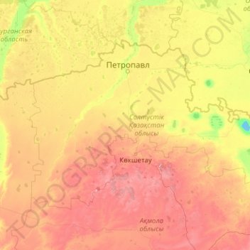
Name: North Kazakhstan Region topographic map, elevation, terrain.
Location: North Kazakhstan Region, Kazakhstan (52.20696 65.96311 55.44217 74.03496)
Average elevation: 659 ft
Minimum elevation: 85 ft
Maximum elevation: 2,687 ft
Make a donation
Gear up for your next adventure:
As an Amazon Associate, this site earns from qualifying purchases at no extra cost to you.
Other topographic maps
Click on a map to view its topography, its elevation and its terrain.
Ridder
Kazakhstan > East Kazakhstan Region
Ridder (Kazakh: Риддер, romanized: Ridder), formerly known as Leninogorsk (Russian: Лениногорск) is a city in the East Kazakhstan Region in north-eastern Kazakhstan. Its population is approximately 50,500 (2009 Census results). The city is situated in the south-western Altai Mountains and…
Average elevation: 2,687 ft
Aksay
Kazakhstan > West Kazakhstan Region > Börli district > Ақсай қалалық әкімдігі
Average elevation: 223 ft
Make a donation
Gear up for your next adventure:
As an Amazon Associate, this site earns from qualifying purchases at no extra cost to you.
Burabay State National Nature Park
Kazakhstan > Akmola Region > Burabay District
Average elevation: 1,201 ft
Жайық
Kazakhstan > West Kazakhstan Region > Baiterek District > Байқоныс ауылдық округі
Average elevation: 108 ft
Make a donation
Gear up for your next adventure:
As an Amazon Associate, this site earns from qualifying purchases at no extra cost to you.
Сарыөзек – Жаркент
Kazakhstan > Jetisu Region > Kerbulaq District > Ақ Сұңқар
Average elevation: 3,123 ft
Make a donation
Gear up for your next adventure:
As an Amazon Associate, this site earns from qualifying purchases at no extra cost to you.
Жарсуат
Kazakhstan > West Kazakhstan Region > Börli district > Жарсуат ауылдық округі
Average elevation: 207 ft
Бөрлі
Kazakhstan > West Kazakhstan Region > Börli district > Бөрлі ауылдық округі
Average elevation: 177 ft
Қазақстан
Kazakhstan > Turkistan Region > Keles District > Бірлесу ауылдық округі
Average elevation: 1,030 ft
Make a donation
Gear up for your next adventure:
As an Amazon Associate, this site earns from qualifying purchases at no extra cost to you.
Make a donation
Gear up for your next adventure:
As an Amazon Associate, this site earns from qualifying purchases at no extra cost to you.
Border Kazakhstan - Russia
Kazakhstan > East Kazakhstan Region > Katonkaragay District
Average elevation: 8,780 ft
Make a donation
Gear up for your next adventure:
As an Amazon Associate, this site earns from qualifying purchases at no extra cost to you.
Lake Kamyslybas
Kazakhstan > Kyzylorda Region > Aral District
Lake Kamyslybas (Kazakh: Қамыстыбас, Qamystybas) is a large saltwater lake in the Kyzylorda Region, Kazakhstan. It has an area of 176 km2, although the water level in the lake often fluctuates. It has a maximum depth of 10 meters with a coastline 116 km long at an elevation of 58 meters above sea…
Average elevation: 236 ft
Make a donation
Gear up for your next adventure:
As an Amazon Associate, this site earns from qualifying purchases at no extra cost to you.
Talgar
Kazakhstan > Almaty Region > Talgar District
Talgar has a total area of 18.8 square km (7.3 mi²). The grade of the town's built-up areas is consistent with the natural unevenness of its overall natural geography. The average land elevation is 1250 m above sea level. The lowest points are in the northern part of the town at 1000 m, while the highest…
Average elevation: 3,215 ft
Дикан баба
Kazakhstan > Turkistan Region > Сарыагашский район > Дикан баба
Average elevation: 1,729 ft
Make a donation
Gear up for your next adventure:
As an Amazon Associate, this site earns from qualifying purchases at no extra cost to you.
Make a donation
Gear up for your next adventure:
As an Amazon Associate, this site earns from qualifying purchases at no extra cost to you.
Новоникольское
Kazakhstan > North Kazakhstan Region > Qyzyljar District > Новоникольский сельский округ
Average elevation: 354 ft