
Make a donation
Gear up for your next adventure:
As an Amazon Associate, this site earns from qualifying purchases at no extra cost to you.
Manitoba topographic map
Click on the map to display elevation.
Make a donation
Gear up for your next adventure:
As an Amazon Associate, this site earns from qualifying purchases at no extra cost to you.
About this map
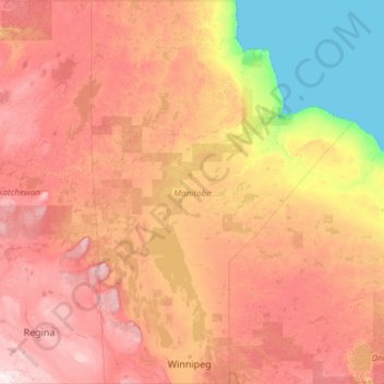
Name: Manitoba topographic map, elevation, terrain.
Location: Manitoba, Canada (48.99886 -102.00758 59.99951 -88.98653)
Average elevation: 961 ft
Minimum elevation: -3 ft
Maximum elevation: 3,284 ft
Make a donation
Gear up for your next adventure:
As an Amazon Associate, this site earns from qualifying purchases at no extra cost to you.
Other topographic maps
Click on a map to view its topography, its elevation and its terrain.
Toronto
Despite its deep ravines, Toronto is not remarkably hilly, but its elevation does increase steadily away from the lake. Elevation differences range from 76.5 metres (251 ft) above sea level at the Lake Ontario shore to 209 m (686 ft) ASL near the York University grounds in the city's north end at the…
Average elevation: 371 ft
London
Canada > Ontario > London > London
London has a humid continental climate (Köppen Dfb), though due to its downwind location relative to Lake Huron and elevation changes across the city, it is virtually on the Dfa/Dfb (hot summer) boundary favouring the former climate zone to the southwest of the confluence of the South and North Thames Rivers,…
Average elevation: 879 ft
Make a donation
Gear up for your next adventure:
As an Amazon Associate, this site earns from qualifying purchases at no extra cost to you.
Guelph
This region of Ontario has cold winters and warm, humid summers, falling into the Köppen climate classification Dfb zone, with moderately high rainfall and snowfall. It is generally a couple of degrees cooler than lower elevation regions on the Great Lakes shorelines, especially so in winter, the exception…
Average elevation: 1,129 ft
Make a donation
Gear up for your next adventure:
As an Amazon Associate, this site earns from qualifying purchases at no extra cost to you.
Banff
Canada > Alberta > Banff > Banff
Banff is a town within Banff National Park in Alberta, Canada. It is located in Alberta's Rockies along the Trans-Canada Highway, approximately 126 km (78 mi) west of Calgary and 58 km (36 mi) east of Lake Louise. At 1,400 to 1,630 m (4,590 to 5,350 ft) above sea level, Banff is the community with the second…
Average elevation: 5,299 ft
Make a donation
Gear up for your next adventure:
As an Amazon Associate, this site earns from qualifying purchases at no extra cost to you.
Nanoose Bay
Canada > British Columbia > Regional District of Nanaimo > Area E (Nanoose Bay)
Average elevation: 190 ft
Make a donation
Gear up for your next adventure:
As an Amazon Associate, this site earns from qualifying purchases at no extra cost to you.
Nose Hill Park
Names currently associated with topographical features in and near Nose Hill Park reflect the impact of the European newcomers and European trade goods on the Peigan. For example, Spy Hill, the westward extension of Nose Hill, derived its present name from the aboriginal practice of communicating with distant…
Average elevation: 3,852 ft
Make a donation
Gear up for your next adventure:
As an Amazon Associate, this site earns from qualifying purchases at no extra cost to you.
Make a donation
Gear up for your next adventure:
As an Amazon Associate, this site earns from qualifying purchases at no extra cost to you.
Secret Cove
Canada > British Columbia > Sunshine Coast Regional District > Area B (Halfmoon Bay)
Average elevation: 289 ft
Make a donation
Gear up for your next adventure:
As an Amazon Associate, this site earns from qualifying purchases at no extra cost to you.
Langley Township
Canada > British Columbia > Metro Vancouver Regional District > Township of Langley > Langley Township
Average elevation: 121 ft
Brandywine
Canada > British Columbia > Squamish-Lillooet Regional District > Area D (Elaho/Garibaldi)
Average elevation: 1,690 ft
Make a donation
Gear up for your next adventure:
As an Amazon Associate, this site earns from qualifying purchases at no extra cost to you.
Naramata
Canada > British Columbia > Regional District of Okanagan-Similkameen > Area E (Naramata/Greyback)
Average elevation: 1,358 ft
Make a donation
Gear up for your next adventure:
As an Amazon Associate, this site earns from qualifying purchases at no extra cost to you.
Lethbridge
Canada > Alberta > Lethbridge
Its high elevation of 929 m (3,047.9 ft) and close proximity to the Rocky Mountains provides Lethbridge with cooler summers than other locations in the Canadian Prairies. These factors protect the city from strong northwest and southwest winds and contribute to frequent chinook winds during the winter.…
Average elevation: 3,012 ft
Canmore
Canada > Alberta > Town of Canmore
Elevation Place opened in April 2013 as Canmore's new recreation facility. Construction of the facility began in 2012 to replace the Canmore Recreation Centre (the community's old facility). The facility offers an 8-lane 25m lap pool, a world class climbing wall developed by Walltopia, two cardio rooms, a…
Average elevation: 5,135 ft
Make a donation
Gear up for your next adventure:
As an Amazon Associate, this site earns from qualifying purchases at no extra cost to you.
Peterborough
Canada > Ontario > Peterborough
Peterborough's topography is largely defined by land formations created by the receding Wisconsian glaciers 10,000–15,000 years ago. The South End and Downtown portions of the City sit on what was the bottom of the glacial Lake Peterborough—part of a glacial spillway created when glacial meltwaters from…
Average elevation: 771 ft
Baddeck Bridge
Canada > Nova Scotia > Municipality of Victoria County > Big Baddeck
Average elevation: 62 ft
Laurentian Mountains
One of Quebec's official regions is called Laurentides. The mountain range runs through four other regions; Capitale-Nationale, Outaouais, Lanaudière, and Mauricie. The elevation generally ranges from around 500 m (1,640 ft) to 1,000 m (3,280 ft) with Mont Raoul-Blanchard being its highest peak, at 1,166 m…
Average elevation: 1,142 ft
Make a donation
Gear up for your next adventure:
As an Amazon Associate, this site earns from qualifying purchases at no extra cost to you.
Kentucky Lake
Canada > British Columbia > Thompson-Nicola Regional District > Area N (Beautiful Nicola Valley - South)
Average elevation: 3,668 ft
Make a donation
Gear up for your next adventure:
As an Amazon Associate, this site earns from qualifying purchases at no extra cost to you.
Malakwa
Canada > British Columbia > Columbia-Shuswap Regional District > Area E (Eagle River Valley)
Average elevation: 1,542 ft
Fairmont Hot Springs
Canada > British Columbia > Regional District of East Kootenay > Area F (Columbia Lake/Windermere Lake)
Average elevation: 3,018 ft
Make a donation
Gear up for your next adventure:
As an Amazon Associate, this site earns from qualifying purchases at no extra cost to you.
Cochrane
Canada > Alberta > Town of Cochrane > Cochrane
Cochrane is situated at the base of Big Hill in the Bow River Valley. It sits at an elevation of 1,186 m (3,891 ft). The town is intersected by Highway 1A and Highway 22. Cochrane has a reputation for its western culture, which can easily be felt when one wanders the streets (particularly Main Street). The…
Average elevation: 3,953 ft
Riding Mountain National Park
The climate in the Riding Mountain region is similar to that of other regions of southwestern Manitoba. Under the Köppen classification it has a continental climate. It includes grasslands, upland boreal and eastern deciduous forest ecosystems. The park has hot summers and cold winters, with annual rainfall…
Average elevation: 1,601 ft
Make a donation
Gear up for your next adventure:
As an Amazon Associate, this site earns from qualifying purchases at no extra cost to you.
Make a donation
Gear up for your next adventure:
As an Amazon Associate, this site earns from qualifying purchases at no extra cost to you.
Spider Lake
Canada > British Columbia > Thompson-Nicola Regional District > Area O (Lower North Thompson)
Average elevation: 4,455 ft
Willow River
Canada > British Columbia > Regional District of Fraser-Fort George > Area F (Willow River/Upper Fraser)
Average elevation: 2,037 ft
Make a donation
Gear up for your next adventure:
As an Amazon Associate, this site earns from qualifying purchases at no extra cost to you.
Manning Park
Canada > British Columbia > Regional District of Okanagan-Similkameen > Area H (Manning Park/Tulameen/Siwash)
Average elevation: 4,659 ft
Mount Tolmie
Canada > British Columbia > Capital Regional District > Saanich
Average elevation: 171 ft
Make a donation
Gear up for your next adventure:
As an Amazon Associate, this site earns from qualifying purchases at no extra cost to you.
Oxtongue Lake
Canada > Ontario > Haliburton County > Algonquin Highlands > Oxtongue Lake
Average elevation: 1,293 ft
Make a donation
Gear up for your next adventure:
As an Amazon Associate, this site earns from qualifying purchases at no extra cost to you.
Make a donation
Gear up for your next adventure:
As an Amazon Associate, this site earns from qualifying purchases at no extra cost to you.
Make a donation
Gear up for your next adventure:
As an Amazon Associate, this site earns from qualifying purchases at no extra cost to you.
Hudson Bay Lowlands
Canada > Ontario > Kenora District > Unorganized Kenora District
Average elevation: 56 ft
Make a donation
Gear up for your next adventure:
As an Amazon Associate, this site earns from qualifying purchases at no extra cost to you.
Annapolis Valley
Canada > Nova Scotia > Municipality of the County of Kings > Auburn
Average elevation: 253 ft
Make a donation
Gear up for your next adventure:
As an Amazon Associate, this site earns from qualifying purchases at no extra cost to you.
Make a donation
Gear up for your next adventure:
As an Amazon Associate, this site earns from qualifying purchases at no extra cost to you.
Foymount
Canada > Ontario > Renfrew County > Bonnechere Valley
The location is also popular for amateur astronomers given the high altitude and low levels of artificial light.
Average elevation: 1,417 ft
Make a donation
Gear up for your next adventure:
As an Amazon Associate, this site earns from qualifying purchases at no extra cost to you.
Mount Royal
Canada > Quebec > Urban agglomeration of Montreal > Montreal
The hill is part of the Monteregian Hills situated between the Laurentians and the Appalachian Mountains. It gave its Latin name, Mons Regius, to the Monteregian chain. The hill consists of three peaks: Colline de la Croix (or Mont Royal proper) at 233 m (764 ft), Colline d'Outremont (or Mount Murray, in the…
Average elevation: 364 ft
Quebec
Canada > Quebec > Urban agglomeration of Québec
Quebec City was built on the north bank of the Saint Lawrence River, where it narrows and meets the mouth of the Saint-Charles River. Old Quebec is located on top and at the foot of Cap-Diamant, which is on the eastern edge of a plateau called the promontory of Quebec (Quebec hill). Because of this topographic…
Average elevation: 328 ft
Make a donation
Gear up for your next adventure:
As an Amazon Associate, this site earns from qualifying purchases at no extra cost to you.