
Make a donation
Gear up for your next adventure:
As an Amazon Associate, this site earns from qualifying purchases at no extra cost to you.
Longhua District topographic map
Click on the map to display elevation.
Make a donation
Gear up for your next adventure:
As an Amazon Associate, this site earns from qualifying purchases at no extra cost to you.
About this map
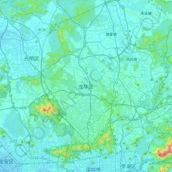
Name: Longhua District topographic map, elevation, terrain.
Average elevation: 220 ft
Minimum elevation: -13 ft
Maximum elevation: 2,828 ft
Make a donation
Gear up for your next adventure:
As an Amazon Associate, this site earns from qualifying purchases at no extra cost to you.
Other topographic maps
Click on a map to view its topography, its elevation and its terrain.
Guangzhou City
The elevation of the prefecture generally increases from southwest to northeast, with mountains forming the backbone of the city and the ocean comprising the front. Tiantang Peak (simplified Chinese: 天堂顶; traditional Chinese: 天堂頂, "Heavenly Peak") is the highest point of elevation at 1,210 m (3,970…
Average elevation: 322 ft
Shenzhen Bay Port Hong Kong Port Area
China > Guangdong Province > Nanshan District
Average elevation: 3 ft
Make a donation
Gear up for your next adventure:
As an Amazon Associate, this site earns from qualifying purchases at no extra cost to you.
Huangpu District
China > Guangdong Province > Guangzhou City
The district is pioneering in the low-altitude economy, which includes the development of aerial innovations. Notably, EHang Holdings, based in Huangpu, received the first certification for manned eVTOL (electric vertical take-off and landing) aircraft, positioning the district at the forefront of the urban…
Average elevation: 148 ft
Make a donation
Gear up for your next adventure:
As an Amazon Associate, this site earns from qualifying purchases at no extra cost to you.
Guangzhou City
The elevation of the prefecture generally increases from southwest to northeast, with mountains forming the backbone of the city and the ocean comprising the front. Tiantang Peak is the highest point of elevation at 1,210 metres (3,970 feet) above sea level.
Average elevation: 322 ft
Make a donation
Gear up for your next adventure:
As an Amazon Associate, this site earns from qualifying purchases at no extra cost to you.
Make a donation
Gear up for your next adventure:
As an Amazon Associate, this site earns from qualifying purchases at no extra cost to you.
Zhujiangkou Chinese White Dolphin National Nature Reserve
Average elevation: 20 ft
Meizhou
Meizhou has a humid subtropical climate (Köppen Cfa), with short, mild, overcast winters and long, very hot, humid summers. The monthly daily average temperature in January is 12.6 °C (54.7 °F), and in July is 28.9 °C (84.0 °F). From April to June, rainfall is the heaviest and most frequent. Though…
Average elevation: 974 ft
Make a donation
Gear up for your next adventure:
As an Amazon Associate, this site earns from qualifying purchases at no extra cost to you.
Make a donation
Gear up for your next adventure:
As an Amazon Associate, this site earns from qualifying purchases at no extra cost to you.
Chaozhou
The Chaozhou territory is mountainous. In particular, the nearby Phoenix Mountain's peak is located 1,497 meters (4,911 ft) above sea level. The main nearby rivers are the Huanggang River and the Han River. The Han River flows from west to southeast, and ramps through downtown Chaozhou; the Huanggang river…
Average elevation: 686 ft
Make a donation
Gear up for your next adventure:
As an Amazon Associate, this site earns from qualifying purchases at no extra cost to you.
Make a donation
Gear up for your next adventure:
As an Amazon Associate, this site earns from qualifying purchases at no extra cost to you.
Nanshan District
At 587 meters (1,926 ft) tall, Yangtaishan has the highest elevation in the district, with Tanglangshan being the second at 430 meters (1,411 ft), and Nanshan, third, at 336 meters (1,102 ft). The district has a total coastline of 55.18 kilometers (34.29 mi).
Average elevation: 115 ft
Make a donation
Gear up for your next adventure:
As an Amazon Associate, this site earns from qualifying purchases at no extra cost to you.
Make a donation
Gear up for your next adventure:
As an Amazon Associate, this site earns from qualifying purchases at no extra cost to you.
Make a donation
Gear up for your next adventure:
As an Amazon Associate, this site earns from qualifying purchases at no extra cost to you.
Guangdong-Macao In-Depth Cooperation Zone in Hengqin
Average elevation: 66 ft
Make a donation
Gear up for your next adventure:
As an Amazon Associate, this site earns from qualifying purchases at no extra cost to you.
Make a donation
Gear up for your next adventure:
As an Amazon Associate, this site earns from qualifying purchases at no extra cost to you.
Hengli
China > Guangdong Province > Dongguan
Hengli Town is located on the banks of Huanbao and Yinhe Rivers. The Congguanshen Expressway crosses the eastern part of the town. It has an average elevation of 8 meters above the sea level.
Average elevation: 26 ft
Make a donation
Gear up for your next adventure:
As an Amazon Associate, this site earns from qualifying purchases at no extra cost to you.
Make a donation
Gear up for your next adventure:
As an Amazon Associate, this site earns from qualifying purchases at no extra cost to you.
Make a donation
Gear up for your next adventure:
As an Amazon Associate, this site earns from qualifying purchases at no extra cost to you.
Make a donation
Gear up for your next adventure:
As an Amazon Associate, this site earns from qualifying purchases at no extra cost to you.
Make a donation
Gear up for your next adventure:
As an Amazon Associate, this site earns from qualifying purchases at no extra cost to you.
Make a donation
Gear up for your next adventure:
As an Amazon Associate, this site earns from qualifying purchases at no extra cost to you.
Make a donation
Gear up for your next adventure:
As an Amazon Associate, this site earns from qualifying purchases at no extra cost to you.
Make a donation
Gear up for your next adventure:
As an Amazon Associate, this site earns from qualifying purchases at no extra cost to you.
Lianhua Sub-district
China > Guangdong Province > Futian District > Lianhua Sub-district
Average elevation: 69 ft
Futian Sub-district
China > Guangdong Province > Futian District > Futian Sub-district
Average elevation: 26 ft
Xili Sub-district
China > Guangdong Province > Nanshan District > Xili Sub-district
Average elevation: 220 ft
Make a donation
Gear up for your next adventure:
As an Amazon Associate, this site earns from qualifying purchases at no extra cost to you.
Tianchi (Heaven Lake)
China > Guangdong Province > Chao'an District > Fenghuang
Average elevation: 3,455 ft
Qingyuan City
Qingyuan's administrative area ranges in latitude from 23° 26' 56" to 25° 11' 40" N, and in longitude from 111° 55' 17" to 113° 55' 34" E; its urban area is located just north of the Tropic of Cancer, about 60 km (37 mi) from the urban area of Guangzhou and 200 km (120 mi) from both Hong Kong and Macau.…
Average elevation: 1,145 ft
Taoyuan Sub-district
China > Guangdong Province > Nanshan District > Taoyuan Sub-district
Average elevation: 184 ft
Make a donation
Gear up for your next adventure:
As an Amazon Associate, this site earns from qualifying purchases at no extra cost to you.
Bantian Sub-district
China > Guangdong Province > Longgang District > Bantian Sub-district
Average elevation: 315 ft
Make a donation
Gear up for your next adventure:
As an Amazon Associate, this site earns from qualifying purchases at no extra cost to you.
Wenchong Subdistrict
China > Guangdong Province > Huangpu District > Wenchong Subdistrict
Average elevation: 56 ft
Dongxiao Sub-district
China > Guangdong Province > Luohu District > Dongxiao Sub-district
Average elevation: 135 ft
Make a donation
Gear up for your next adventure:
As an Amazon Associate, this site earns from qualifying purchases at no extra cost to you.