
安塞区 topographic map
Interactive map
Click on the map to display elevation.
About this map
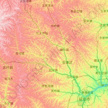
Name: 安塞区 topographic map, elevation, terrain.
Location: 安塞区, 延安市, 陕西省, 中国 (36.51634 108.84761 37.32703 109.43965)
Average elevation: 4,291 ft
Minimum elevation: 2,989 ft
Maximum elevation: 5,840 ft
安塞区在中国陕西省北部、延河上游,是延安市北部的一个市辖区。面积2950平方公里,人口15万,平均海拔1200米,大部分是山地,是典型的陕北黄土高原丘陵沟壑地形。编码610624,邮编717400,区政府驻真武洞街道。
Other topographic maps
Click on a map to view its topography, its elevation and its terrain.