
Pernem topographic map
Interactive map
Click on the map to display elevation.
About this map
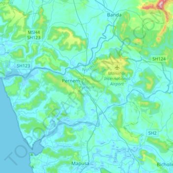
Name: Pernem topographic map, elevation, terrain.
Location: Pernem, North Goa, Goa, India (15.61479 73.68295 15.80076 73.95230)
Average elevation: 151 ft
Minimum elevation: -10 ft
Maximum elevation: 1,453 ft
Other topographic maps
Click on a map to view its topography, its elevation and its terrain.
Gaondongrim
Gaondongrim, Canacona, South Goa District, Goa, India
Average elevation: 351 ft
Corjuem Fort
India > Goa > Bardez > Corjuem
Corjuem Fort, Bicholim Road, Aldona, Corjuem, Bardez, North Goa District, Goa, 403502, India
Average elevation: 43 ft
Collem
India > Goa > Dharbandora
Collem, Dharbandora, South Goa District, Goa, India
Average elevation: 295 ft
Divar Island
India > Goa > Tiswadi > Piedade
Divar Island, Piedade, Tiswadi, North Goa District, Goa, India
Average elevation: 36 ft
Miramar beach
India > Goa > Tiswadi > Panaji
Miramar beach, Dr. Jack Sequeira Road, St. Mary's Colony, Miramar, Panaji, Tiswadi, North Goa District, Goa, 403004, India
Average elevation: 10 ft
Pilerne Lake
India > Goa > Bardez > Sangolda
Pilerne Lake, Sangolda, Bardez, North Goa, Goa, India
Average elevation: 128 ft
Velsao Beach
Velsao Beach, Mormugao, South Goa, Goa, 403712, India
Average elevation: 23 ft
Arambol Sweet Water Lake
India > Goa > Pernem > Arambol
Arambol Sweet Water Lake, Arambol, Pernem, North Goa, Goa, India
Average elevation: 82 ft
Dona Paula
India > Goa > Dona Paula
Dona Paula, North Goa, Goa, 403 004, India
Average elevation: 16 ft
Socorro Plateau
Socorro Plateau, NH66, Porvorim, Bardez, North Goa, Goa, 403500, India
Average elevation: 108 ft
Chorla Ghat
Chorla Ghat, NH748AA, Satari, North Goa, Goa, India
Average elevation: 1,631 ft