
Make a donation
Gear up for your next adventure:
As an Amazon Associate, this site earns from qualifying purchases at no extra cost to you.
Haida Gwaii topographic map
Click on the map to display elevation.
Make a donation
Gear up for your next adventure:
As an Amazon Associate, this site earns from qualifying purchases at no extra cost to you.
About this map
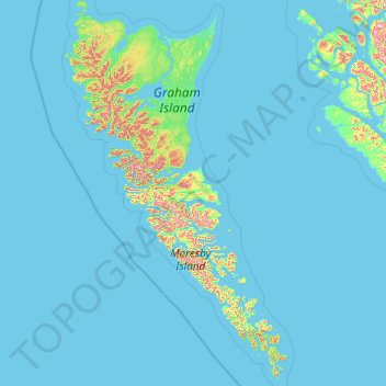
Name: Haida Gwaii topographic map, elevation, terrain.
Location: Haida Gwaii, British Columbia, Canada (51.90529 -133.20208 54.26126 -130.93520)
Average elevation: 121 ft
Minimum elevation: 0 ft
Maximum elevation: 3,419 ft
Make a donation
Gear up for your next adventure:
As an Amazon Associate, this site earns from qualifying purchases at no extra cost to you.
Other topographic maps
Click on a map to view its topography, its elevation and its terrain.
Richmond
Canada > British Columbia > Metro Vancouver Regional District > Richmond
Average elevation: 49 ft
Abbotsford
Canada > British Columbia > Fraser Valley Regional District > Abbotsford
Average elevation: 377 ft
Ryder Lake
Canada > British Columbia > Fraser Valley Regional District > Chilliwack
Average elevation: 837 ft
Make a donation
Gear up for your next adventure:
As an Amazon Associate, this site earns from qualifying purchases at no extra cost to you.
Duffey Lake
Canada > British Columbia > Squamish-Lillooet Regional District > Area B (Cayoosh/Pavilion)
Average elevation: 5,049 ft
Qualicum Beach
Canada > British Columbia > Regional District of Nanaimo > Qualicum Beach > Qualicum Beach
Average elevation: 154 ft
Nemaiah Valley
Canada > British Columbia > Cariboo Regional District > Area J (West Chilcotin)
Average elevation: 4,167 ft
Make a donation
Gear up for your next adventure:
As an Amazon Associate, this site earns from qualifying purchases at no extra cost to you.
Powder King Peak
Canada > British Columbia > Regional District of Fraser-Fort George > Area G (Crooked River/Parsnip)
Average elevation: 4,531 ft
Mount Wrottesley
Canada > British Columbia > Sunshine Coast Regional District > Area F (West Howe Sound)
Average elevation: 3,530 ft
Kettle Lakes
Canada > British Columbia > Regional District of Fraser-Fort George > Area H (Robson Valley/Canoe)
Average elevation: 3,901 ft
Whistler
Canada > British Columbia > Squamish-Lillooet Regional District > Whistler Resort Municipality > Whistler
Average elevation: 3,268 ft
Make a donation
Gear up for your next adventure:
As an Amazon Associate, this site earns from qualifying purchases at no extra cost to you.
Mount Raleigh
Canada > British Columbia > Strathcona Regional District > Area B (Discovery Islands/Mainland Inlets)
Mount Raleigh, elevation 3,132 m (10,276 ft), is one of the principal summits of the Pacific Ranges of the Coast Mountains of southern British Columbia in Canada. It is located just southeast of the confluence of the Southgate and Bishop Rivers, northeast of the head of Bute Inlet, and is the highest summit…
Average elevation: 7,920 ft
Harrison Mills
Canada > British Columbia > Fraser Valley Regional District > Kent
Average elevation: 177 ft
Kootenay National Park
Canada > British Columbia > Regional District of East Kootenay
Kootenay National Park is a national park of Canada in southeastern British Columbia. The park consists of 1,406 km2 (543 sq mi) of the Canadian Rockies, including parts of the Kootenay and Park mountain ranges, the Kootenay River and the entirety of the Vermilion River. While the Vermilion River is completely…
Average elevation: 6,010 ft
Baron Lake
Canada > British Columbia > Regional District of Kitimat-Stikine > Area C (Butedale/Kitlope/Kitsumkalum)
Average elevation: 1,086 ft
Make a donation
Gear up for your next adventure:
As an Amazon Associate, this site earns from qualifying purchases at no extra cost to you.
Butedale
Canada > British Columbia > Regional District of Kitimat-Stikine > Area C (Butedale/Kitlope/Kitsumkalum)
Average elevation: 869 ft
Sugarbowl Mountain
Canada > British Columbia > Regional District of Fraser-Fort George > Area F (Willow River/Upper Fraser)
Average elevation: 5,243 ft
Sinclair Mills
Canada > British Columbia > Regional District of Fraser-Fort George > Area F (Willow River/Upper Fraser)
Average elevation: 2,162 ft
Darke Lake
Canada > British Columbia > Regional District of Okanagan-Similkameen > Area F (Trout Creek Valley)
Average elevation: 3,376 ft
Make a donation
Gear up for your next adventure:
As an Amazon Associate, this site earns from qualifying purchases at no extra cost to you.
Mount Thor
Canada > British Columbia > Regional District of Central Kootenay > Area K (The Arrow Lakes)
Average elevation: 7,290 ft
Institute Park
Canada > British Columbia > Metro Vancouver Regional District
Average elevation: 581 ft
New Westminster
Canada > British Columbia > Metro Vancouver Regional District
Average elevation: 285 ft
Wilmer
Canada > British Columbia > Regional District of East Kootenay > Area G (Forster Creek/Mount Assiniboine)
Average elevation: 2,890 ft
Make a donation
Gear up for your next adventure:
As an Amazon Associate, this site earns from qualifying purchases at no extra cost to you.
West Bench
Canada > British Columbia > Regional District of Okanagan-Similkameen > Area F (Trout Creek Valley)
Average elevation: 1,768 ft
Spruce Lake
Canada > British Columbia > Squamish-Lillooet Regional District > Area A (Upper Bridge River Valley)
Average elevation: 5,538 ft
Ducie Island
Canada > British Columbia > North Coast Regional District > Area A (North Skeena)
Average elevation: 3 ft
Sugar Mountain
Canada > British Columbia > Metro Vancouver Regional District > Anmore
Average elevation: 591 ft
Make a donation
Gear up for your next adventure:
As an Amazon Associate, this site earns from qualifying purchases at no extra cost to you.
Snow Mountain
Canada > British Columbia > Strathcona Regional District > Area B (Discovery Islands/Mainland Inlets)
Average elevation: 2,057 ft
Thompson Plateau
Canada > British Columbia > Regional District of Central Okanagan > East Central Okanagan Electoral Area
Average elevation: 4,760 ft
Durieu
Canada > British Columbia > Fraser Valley Regional District > Area F (McConnell Creek/Hatzic Prairie)
Average elevation: 466 ft
Capilano Lake
Canada > British Columbia > Metro Vancouver Regional District > West Vancouver
Average elevation: 1,158 ft
Make a donation
Gear up for your next adventure:
As an Amazon Associate, this site earns from qualifying purchases at no extra cost to you.
Stuie
Canada > British Columbia > Central Coast Regional District > Area C (Hagensborg/Talchako/Atnarko)
Average elevation: 1,421 ft
Strathnaver
Canada > British Columbia > Cariboo Regional District > Area B (Quesnel West/Bouchie Lake)
Average elevation: 2,346 ft
Serpentine Lake
Canada > British Columbia > Squamish-Lillooet Regional District > Area B (Cayoosh/Pavilion)
Average elevation: 6,309 ft
Make a donation
Gear up for your next adventure:
As an Amazon Associate, this site earns from qualifying purchases at no extra cost to you.
Mary's Peak
Canada > British Columbia > Capital Regional District > Juan de Fuca Electoral Area
Average elevation: 1,503 ft
Harry Wipper Park
Canada > British Columbia > Regional District of Nanaimo > Nanaimo
Average elevation: 253 ft
Palisade Mountain
Canada > British Columbia > Columbia-Shuswap Regional District > Area A (Kicking Horse/Kinbasket Lake)
Average elevation: 7,746 ft
Make a donation
Gear up for your next adventure:
As an Amazon Associate, this site earns from qualifying purchases at no extra cost to you.
Copeland Creek
Canada > British Columbia > Columbia-Shuswap Regional District > Area B (Shelter Bay/Mica Creek)
Average elevation: 5,210 ft
Grave Island
Canada > British Columbia > Regional District of Mount Waddington > Area A (Seymour Inlet/Knight Inlet)
Average elevation: 30 ft
Puma
Canada > British Columbia > Squamish-Lillooet Regional District > Area C (Pemberton Valley/Mount Currie/D'Arcy)
Average elevation: 5,092 ft
Make a donation
Gear up for your next adventure:
As an Amazon Associate, this site earns from qualifying purchases at no extra cost to you.
Little Big Horn
Canada > British Columbia > Squamish-Lillooet Regional District > Area A (Upper Bridge River Valley)
Average elevation: 6,516 ft
Stoney Creek
Canada > British Columbia > Regional District of Central Kootenay > Area K (The Arrow Lakes)
Average elevation: 4,249 ft
Hastings Hill
Canada > British Columbia > Strathcona Regional District > Area B (Discovery Islands/Mainland Inlets)
Average elevation: 594 ft
Devastator Peak
Canada > British Columbia > Squamish-Lillooet Regional District > Area C (Pemberton Valley/Mount Currie/D'Arcy)
Average elevation: 5,925 ft
Make a donation
Gear up for your next adventure:
As an Amazon Associate, this site earns from qualifying purchases at no extra cost to you.
Stump Lake
Canada > British Columbia > Regional District of Kootenay Boundary > Area E (Beaverdell/West Boundary)
Average elevation: 4,334 ft
Findlay Creek
Canada > British Columbia > Regional District of East Kootenay > Area F (Columbia Lake/Windermere Lake)
Average elevation: 6,109 ft
Submarine Mountain
Canada > British Columbia > Peace River Regional District > Area E (Moberly Lake/Sukunka Valley)
Average elevation: 2,703 ft
Make a donation
Gear up for your next adventure:
As an Amazon Associate, this site earns from qualifying purchases at no extra cost to you.
Rocky Mountains
Canada > British Columbia > Peace River Regional District > Area D (Kiskatinaw Valley)
Average elevation: 4,783 ft
Monarch Mountain
Canada > British Columbia > Regional District of Mount Waddington > Area A (Seymour Inlet/Knight Inlet)
Average elevation: 8,770 ft
Notch Peak
Canada > British Columbia > Peace River Regional District > Area B (Finlay Valley/Beatton Valley)
Average elevation: 5,256 ft
Mount Cairnes
Canada > British Columbia > Columbia-Shuswap Regional District > Area A (Kicking Horse/Kinbasket Lake)
Average elevation: 8,179 ft
Make a donation
Gear up for your next adventure:
As an Amazon Associate, this site earns from qualifying purchases at no extra cost to you.
Dunkley
Canada > British Columbia > Cariboo Regional District > Area B (Quesnel West/Bouchie Lake)
Average elevation: 2,375 ft
Holberg
Canada > British Columbia > Regional District of Mount Waddington > Area B (Quatsino Sound/Cape Scott)
Average elevation: 492 ft
Yukness Mountain
Canada > British Columbia > Columbia-Shuswap Regional District > Area A (Kicking Horse/Kinbasket Lake)
Average elevation: 8,432 ft
Mount Browne
Canada > British Columbia > Regional District of Mount Waddington > Area A (Seymour Inlet/Knight Inlet)
Average elevation: 476 ft
Make a donation
Gear up for your next adventure:
As an Amazon Associate, this site earns from qualifying purchases at no extra cost to you.
Slim Mountain
Canada > British Columbia > Squamish-Lillooet Regional District > Area A (Upper Bridge River Valley)
Average elevation: 7,060 ft
Hall Lake
Canada > British Columbia > Regional District of Okanagan-Similkameen > Area H (Manning Park/Tulameen/Siwash)
Average elevation: 3,865 ft
Winlaw
Canada > British Columbia > Regional District of Central Kootenay > Area H (The Slocan Valley)
Average elevation: 2,277 ft
Woodland Hill
Canada > British Columbia > Thompson-Nicola Regional District > Area L (Grasslands)
Average elevation: 4,544 ft
Make a donation
Gear up for your next adventure:
As an Amazon Associate, this site earns from qualifying purchases at no extra cost to you.
Charles Hill
Canada > British Columbia > Regional District of Mount Waddington > Area A (Seymour Inlet/Knight Inlet)
Average elevation: 285 ft
Hagensborg
Canada > British Columbia > Central Coast Regional District > Area C (Hagensborg/Talchako/Atnarko)
Average elevation: 531 ft
Mica Peak
Canada > British Columbia > Peace River Regional District > Area B (Finlay Valley/Beatton Valley)
Average elevation: 5,709 ft
Stanley Glacier
Canada > British Columbia > Columbia-Shuswap Regional District > Area A (Kicking Horse/Kinbasket Lake)
Average elevation: 8,064 ft
Make a donation
Gear up for your next adventure:
As an Amazon Associate, this site earns from qualifying purchases at no extra cost to you.
White Man Pass
Canada > British Columbia > Regional District of East Kootenay > Area F (Columbia Lake/Windermere Lake)
Average elevation: 7,215 ft
Pearl Point
Canada > British Columbia > North Coast Regional District > Area A (North Skeena)
Average elevation: 43 ft
Mount Clore
Canada > British Columbia > Regional District of Kitimat-Stikine > Area C (Butedale/Kitlope/Kitsumkalum)
Average elevation: 5,256 ft
Mayor Island
Canada > British Columbia > Regional District of Mount Waddington > Area A (Seymour Inlet/Knight Inlet)
Average elevation: 16 ft
Make a donation
Gear up for your next adventure:
As an Amazon Associate, this site earns from qualifying purchases at no extra cost to you.
Mount Burwell
Canada > British Columbia > Metro Vancouver Regional District > Electoral Area A
Average elevation: 3,609 ft
Lakelse
Canada > British Columbia > Regional District of Kitimat-Stikine > Area C (Butedale/Kitlope/Kitsumkalum)
Average elevation: 699 ft
Chancellor Peak
Canada > British Columbia > Columbia-Shuswap Regional District > Area A (Kicking Horse/Kinbasket Lake)
Average elevation: 7,762 ft
Make a donation
Gear up for your next adventure:
As an Amazon Associate, this site earns from qualifying purchases at no extra cost to you.
Mount Erskine
Canada > British Columbia > Capital Regional District > Salt Spring Island Electoral Area
Average elevation: 764 ft
Amsbury
Canada > British Columbia > Regional District of Kitimat-Stikine > Area C (Butedale/Kitlope/Kitsumkalum)
Average elevation: 673 ft
Errington
Canada > British Columbia > Regional District of Nanaimo > Area F (Alberni Highway)
Average elevation: 394 ft
Make a donation
Gear up for your next adventure:
As an Amazon Associate, this site earns from qualifying purchases at no extra cost to you.
Mount Chief Pascall
Canada > British Columbia > Squamish-Lillooet Regional District > Area B (Cayoosh/Pavilion)
Average elevation: 5,961 ft
Burnaby
Canada > British Columbia > Metro Vancouver Regional District > Burnaby
Burnaby occupies 98.6 square kilometres (38.1 sq mi) and is located at the geographic centre of the Metro Vancouver area and home to the Metro Vancouver regional government in Metrotown. Situated between the city of Vancouver on the west and Port Moody, Coquitlam, and New Westminster on the east, Burnaby is…
Average elevation: 472 ft
King Peak
Canada > British Columbia > Northern Rockies Regional Municipality
Average elevation: 7,073 ft
Make a donation
Gear up for your next adventure:
As an Amazon Associate, this site earns from qualifying purchases at no extra cost to you.
Surrey
Canada > British Columbia > Metro Vancouver Regional District > Surrey
Average elevation: 213 ft
Nicholson
Canada > British Columbia > Columbia-Shuswap Regional District > Area A (Kicking Horse/Kinbasket Lake)
Average elevation: 2,825 ft
Make a donation
Gear up for your next adventure:
As an Amazon Associate, this site earns from qualifying purchases at no extra cost to you.
Crescent Spur
Canada > British Columbia > Regional District of Fraser-Fort George > Area H (Robson Valley/Canoe)
Average elevation: 2,306 ft
Prince George
Canada > British Columbia > Regional District of Fraser-Fort George > Prince George
Average elevation: 2,323 ft
Fernie
Canada > British Columbia > Regional District of East Kootenay > Fernie
Average elevation: 5,089 ft
Make a donation
Gear up for your next adventure:
As an Amazon Associate, this site earns from qualifying purchases at no extra cost to you.
Mount Revelstoke
Canada > British Columbia > Columbia-Shuswap Regional District > Area B (Shelter Bay/Mica Creek)
Average elevation: 5,676 ft
Upper Saddle Mountain
Canada > British Columbia > Area K (The Arrow Lakes)
Average elevation: 6,273 ft
Hixon
Canada > British Columbia > Regional District of Fraser-Fort George > Area E (Woodpecker/Hixon)
Average elevation: 2,241 ft
Make a donation
Gear up for your next adventure:
As an Amazon Associate, this site earns from qualifying purchases at no extra cost to you.
Nicola
Canada > British Columbia > Thompson-Nicola Regional District > Area M (Beautiful Nicola Valley - North) > Nicola
Average elevation: 2,339 ft
Whiterock Lake
Canada > British Columbia > Thompson-Nicola Regional District > Area M (Beautiful Nicola Valley - North)
Average elevation: 3,422 ft
Kitchener
Canada > British Columbia > Regional District of Central Kootenay > Area B > Kitchener
Average elevation: 3,035 ft
Fort Nelson
Canada > British Columbia > Northern Rockies Regional Municipality
Average elevation: 1,325 ft
Make a donation
Gear up for your next adventure:
As an Amazon Associate, this site earns from qualifying purchases at no extra cost to you.