
Make a donation
Gear up for your next adventure:
As an Amazon Associate, this site earns from qualifying purchases at no extra cost to you.
San Lorenzo Island topographic map
Click on the map to display elevation.
Make a donation
Gear up for your next adventure:
As an Amazon Associate, this site earns from qualifying purchases at no extra cost to you.
About this map
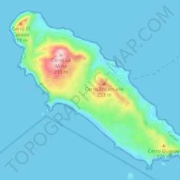
Name: San Lorenzo Island topographic map, elevation, terrain.
Average elevation: 144 ft
Minimum elevation: 0 ft
Maximum elevation: 1,289 ft
Make a donation
Gear up for your next adventure:
As an Amazon Associate, this site earns from qualifying purchases at no extra cost to you.
Other topographic maps
Click on a map to view its topography, its elevation and its terrain.
Colca Canyon
Peru > Arequipa > Choco > Soro
Colca-Arequipa 14 plains of Majes, it is known as the Majes River, and then is known as the Camana before reaching the Pacific Ocean at the town of that name. The Majes River was believed by the Incas to flow directly into the Milky Way. For this reason, they often put sacrifices and gifts to the gods in the…
Average elevation: 10,397 ft
Machu Picchu
Peru > Cusco > Machupicchu > Intihuatana > San Miguel
Animals are also suspected to have migrated to Machu Picchu, as there were several bones found that were not native to the area. Most animal bones found were from llamas and alpacas. These animals naturally live at altitudes of 4,000 meters (13,000 ft) rather than the 2,400 meters (7,900 ft) elevation of Machu…
Average elevation: 7,300 ft
Make a donation
Gear up for your next adventure:
As an Amazon Associate, this site earns from qualifying purchases at no extra cost to you.
Make a donation
Gear up for your next adventure:
As an Amazon Associate, this site earns from qualifying purchases at no extra cost to you.
Make a donation
Gear up for your next adventure:
As an Amazon Associate, this site earns from qualifying purchases at no extra cost to you.
Make a donation
Gear up for your next adventure:
As an Amazon Associate, this site earns from qualifying purchases at no extra cost to you.
Make a donation
Gear up for your next adventure:
As an Amazon Associate, this site earns from qualifying purchases at no extra cost to you.
Make a donation
Gear up for your next adventure:
As an Amazon Associate, this site earns from qualifying purchases at no extra cost to you.
Make a donation
Gear up for your next adventure:
As an Amazon Associate, this site earns from qualifying purchases at no extra cost to you.
Make a donation
Gear up for your next adventure:
As an Amazon Associate, this site earns from qualifying purchases at no extra cost to you.
Make a donation
Gear up for your next adventure:
As an Amazon Associate, this site earns from qualifying purchases at no extra cost to you.
Make a donation
Gear up for your next adventure:
As an Amazon Associate, this site earns from qualifying purchases at no extra cost to you.
Make a donation
Gear up for your next adventure:
As an Amazon Associate, this site earns from qualifying purchases at no extra cost to you.
Make a donation
Gear up for your next adventure:
As an Amazon Associate, this site earns from qualifying purchases at no extra cost to you.
Make a donation
Gear up for your next adventure:
As an Amazon Associate, this site earns from qualifying purchases at no extra cost to you.
Kuelap
Kuélap is located on a limestone ridge on top of a mountain at an elevation of 3000 metres, on the left bank of the Utcubamba River. It belongs to the district of Tingo, Luya Province, Amazonas. The area is covered with cloud forests, with a variety of trees, orchids and epiphytes. The protected zone covers…
Average elevation: 8,530 ft
Make a donation
Gear up for your next adventure:
As an Amazon Associate, this site earns from qualifying purchases at no extra cost to you.
Make a donation
Gear up for your next adventure:
As an Amazon Associate, this site earns from qualifying purchases at no extra cost to you.
Make a donation
Gear up for your next adventure:
As an Amazon Associate, this site earns from qualifying purchases at no extra cost to you.
Make a donation
Gear up for your next adventure:
As an Amazon Associate, this site earns from qualifying purchases at no extra cost to you.
La Rinconada
High in the Andes, La Rinconada has an alpine tundra climate (ET, according to the Köppen climate classification), with no month having mean temperatures even close to the 10 °C (50 °F) threshold that would permit tree growth and a subtropical highland classification for the city. Far above the tree line,…
Average elevation: 16,152 ft
Laguna Aricota
Lake Aricota (possibly from Aymara ari pointed, sharp, quta lake) is a lake in Candarave Province, region of Tacna, Peru. It has an elevation of 2,800 metres (9,186 ft) above sea level.
Average elevation: 10,033 ft
Make a donation
Gear up for your next adventure:
As an Amazon Associate, this site earns from qualifying purchases at no extra cost to you.
Make a donation
Gear up for your next adventure:
As an Amazon Associate, this site earns from qualifying purchases at no extra cost to you.
Make a donation
Gear up for your next adventure:
As an Amazon Associate, this site earns from qualifying purchases at no extra cost to you.
Yerupajá
Based on the elevation provided by the available Digital elevation models, SRTM2 (6558m with voids), SRTM filled with ASTER (6551m with voids), TanDEM-X(6110m with voids), Yerupaja is about 6635 meters above sea level. This altitude was considered due to the lack of topographic data or even handheld GPS data.
Average elevation: 18,494 ft
Make a donation
Gear up for your next adventure:
As an Amazon Associate, this site earns from qualifying purchases at no extra cost to you.
Make a donation
Gear up for your next adventure:
As an Amazon Associate, this site earns from qualifying purchases at no extra cost to you.
Nevado Coropuna
Coropuna is a dormant compound volcano located in the Andes mountains of southeast-central Peru. The upper reaches of Coropuna consist of several perennially snowbound conical summits, lending it the name Nevado Coropuna in Spanish. The complex extends over an area of 240 square kilometres (93 sq mi) and its…
Average elevation: 19,619 ft
Make a donation
Gear up for your next adventure:
As an Amazon Associate, this site earns from qualifying purchases at no extra cost to you.
Make a donation
Gear up for your next adventure:
As an Amazon Associate, this site earns from qualifying purchases at no extra cost to you.
San Salvador de Pampas
Peru > Lima > Atavillos Bajo > San Salvador de Pampas
Average elevation: 10,902 ft
Make a donation
Gear up for your next adventure:
As an Amazon Associate, this site earns from qualifying purchases at no extra cost to you.