
Make a donation
Gear up for your next adventure:
As an Amazon Associate, this site earns from qualifying purchases at no extra cost to you.
Lincoln Parish topographic map
Click on the map to display elevation.
Make a donation
Gear up for your next adventure:
As an Amazon Associate, this site earns from qualifying purchases at no extra cost to you.
About this map
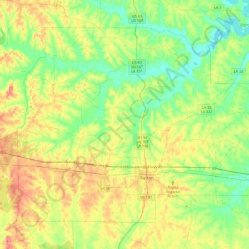
Name: Lincoln Parish topographic map, elevation, terrain.
Location: Lincoln Parish, Louisiana, United States (32.45282 -92.88094 32.76003 -92.41504)
Average elevation: 226 ft
Minimum elevation: 69 ft
Maximum elevation: 512 ft
Louisiana trails, hiking, mountain biking, running and outdoor activities
Make a donation
Gear up for your next adventure:
As an Amazon Associate, this site earns from qualifying purchases at no extra cost to you.
Other topographic maps
Click on a map to view its topography, its elevation and its terrain.
Winnfield
United States > Louisiana > Winn Parish > Winnfield > Winnfield
Winnfield has an elevation of 128 feet (39.0 m). According to the United States Census Bureau, the city has a total area of 3.3 square miles (8.6 km2), all land. North and west of Winnfield, Saline Bayou, a National Wild and Scenic Rivers System waterway, offers blackwater canoeing as well as fishing.
Average elevation: 128 ft
Algiers Point
United States > Louisiana > Orleans Parish > New Orleans > Algiers
Average elevation: 10 ft
Bossier City
United States > Louisiana > Bossier Parish
Bossier City is located at 32°31′4″N 93°41′29″W / 32.51778°N 93.69139°W / 32.51778; -93.69139 (32.517651, −93.691397) within the Ark-La-Tex and has an elevation of 174 feet (53.0 m) above sea level. The city lies primarily on the banks of the Red River, and has a largely flat topography…
Average elevation: 180 ft
Make a donation
Gear up for your next adventure:
As an Amazon Associate, this site earns from qualifying purchases at no extra cost to you.
Make a donation
Gear up for your next adventure:
As an Amazon Associate, this site earns from qualifying purchases at no extra cost to you.
Make a donation
Gear up for your next adventure:
As an Amazon Associate, this site earns from qualifying purchases at no extra cost to you.
South Baton Rouge
United States > Louisiana > East Baton Rouge Parish > Baton Rouge
Average elevation: 43 ft
Make a donation
Gear up for your next adventure:
As an Amazon Associate, this site earns from qualifying purchases at no extra cost to you.
Make a donation
Gear up for your next adventure:
As an Amazon Associate, this site earns from qualifying purchases at no extra cost to you.
Make a donation
Gear up for your next adventure:
As an Amazon Associate, this site earns from qualifying purchases at no extra cost to you.
Marwede Place
United States > Louisiana > East Baton Rouge Parish > Baton Rouge
Average elevation: 56 ft
Make a donation
Gear up for your next adventure:
As an Amazon Associate, this site earns from qualifying purchases at no extra cost to you.
Lakeview
United States > Louisiana > Orleans Parish > New Orleans
Lakeview is located at 30°00′24″N 90°06′28″W / 30.00667°N 90.10778°W / 30.00667; -90.10778 and has an elevation of 0 feet (0.0 m). According to the United States Census Bureau, the district has a total area of 1.61 square miles (4.2 km2). 1.61 square miles (4.2 km2) of which is land and…
Average elevation: 7 ft
Make a donation
Gear up for your next adventure:
As an Amazon Associate, this site earns from qualifying purchases at no extra cost to you.
Make a donation
Gear up for your next adventure:
As an Amazon Associate, this site earns from qualifying purchases at no extra cost to you.
Make a donation
Gear up for your next adventure:
As an Amazon Associate, this site earns from qualifying purchases at no extra cost to you.
Hollygrove
United States > Louisiana > Orleans Parish > New Orleans > Hollygrove
Average elevation: 7 ft
Make a donation
Gear up for your next adventure:
As an Amazon Associate, this site earns from qualifying purchases at no extra cost to you.
Jones Creek
United States > Louisiana > East Baton Rouge Parish > Jones Creek
Average elevation: 43 ft
Make a donation
Gear up for your next adventure:
As an Amazon Associate, this site earns from qualifying purchases at no extra cost to you.
Concord Park
United States > Louisiana > East Baton Rouge Parish > Baton Rouge > Concord Park
Average elevation: 49 ft
Gretna
United States > Louisiana > Jefferson Parish > Gretna > Gretna
Gretna is located at 29°54′59″N 90°3′15″W / 29.91639°N 90.05417°W / 29.91639; -90.05417 (29.916459, -90.054260) and has an elevation of 0 feet (0 m) behind the levee along the Mississippi River.
Average elevation: 7 ft
Tensas River National Wildlife Refuge
United States > Louisiana > Tensas Parish
Average elevation: 75 ft
Make a donation
Gear up for your next adventure:
As an Amazon Associate, this site earns from qualifying purchases at no extra cost to you.
Monroe
United States > Louisiana > Ouachita Parish > Monroe
Located in northeastern Louisiana, Monroe is the center of the Monroe metropolitan statistical area. It is the parish seat of Ouachita Parish, and northeastern Louisiana's economic and cultural hub. Monroe has an elevation of 72 feet (21.9 m) above sea level. According to the United States Census Bureau, the…
Average elevation: 89 ft
Lafayette
United States > Louisiana > Lafayette Parish > Lafayette
Lafayette lies approximately 135 miles (217 km) from New Orleans, 59 miles (95 km) from the state capital of Baton Rouge, 75 miles (121 km) from Lake Charles, and 89 miles (143 km) from Alexandria. The city has an elevation ranging from 36 feet (11.0 m) to 49 feet (15 m) above sea level. According to the…
Average elevation: 30 ft
Hillside
United States > Louisiana > East Baton Rouge Parish > Baton Rouge > Hillside
Average elevation: 39 ft
Make a donation
Gear up for your next adventure:
As an Amazon Associate, this site earns from qualifying purchases at no extra cost to you.
Zachary
United States > Louisiana > East Baton Rouge Parish > Zachary > Zachary
Average elevation: 95 ft
Youngsville
United States > Louisiana > Lafayette Parish > Youngsville > Youngsville
Average elevation: 33 ft
Make a donation
Gear up for your next adventure:
As an Amazon Associate, this site earns from qualifying purchases at no extra cost to you.
Southmoor
United States > Louisiana > East Baton Rouge Parish > Baton Rouge > Southmoor
Average elevation: 52 ft
West Monroe
United States > Louisiana > Ouachita Parish > West Monroe > West Monroe
Average elevation: 98 ft
Make a donation
Gear up for your next adventure:
As an Amazon Associate, this site earns from qualifying purchases at no extra cost to you.
Moss Side Place
United States > Louisiana > East Baton Rouge Parish > Baton Rouge > Moss Side Place
Average elevation: 46 ft
Covington
United States > Louisiana > St. Tammany Parish > Covington > Covington
Average elevation: 30 ft
Make a donation
Gear up for your next adventure:
As an Amazon Associate, this site earns from qualifying purchases at no extra cost to you.
New Orleans
United States > Louisiana > Orleans Parish
Founded in 1718 by French colonists, New Orleans was once the territorial capital of French Louisiana before becoming part of the United States in the Louisiana Purchase of 1803. New Orleans in 1840 was the third most populous city in the United States, and it was the largest city in the American South from…
Average elevation: 3 ft
Prescott Court
United States > Louisiana > East Baton Rouge Parish > Baton Rouge > Prescott Court
Average elevation: 66 ft
Make a donation
Gear up for your next adventure:
As an Amazon Associate, this site earns from qualifying purchases at no extra cost to you.
Make a donation
Gear up for your next adventure:
As an Amazon Associate, this site earns from qualifying purchases at no extra cost to you.
White Hills
United States > Louisiana > East Baton Rouge Parish > White Hills
Average elevation: 79 ft
Make a donation
Gear up for your next adventure:
As an Amazon Associate, this site earns from qualifying purchases at no extra cost to you.
Mississippi River
United States > Louisiana > West Feliciana Parish
The uppermost lock and dam on the Upper Mississippi River is the Upper St. Anthony Falls Lock and Dam in Minneapolis. Above the dam, the river's elevation is 799 feet (244 m). Below the dam, the river's elevation is 750 feet (230 m). This 49-foot (15 m) drop is the largest of all the Mississippi River locks…
Average elevation: 43 ft
Make a donation
Gear up for your next adventure:
As an Amazon Associate, this site earns from qualifying purchases at no extra cost to you.
Cunnard Place
United States > Louisiana > East Baton Rouge Parish > Baton Rouge
Average elevation: 72 ft
Make a donation
Gear up for your next adventure:
As an Amazon Associate, this site earns from qualifying purchases at no extra cost to you.
Make a donation
Gear up for your next adventure:
As an Amazon Associate, this site earns from qualifying purchases at no extra cost to you.
Make a donation
Gear up for your next adventure:
As an Amazon Associate, this site earns from qualifying purchases at no extra cost to you.
Sherwood Oaks
United States > Louisiana > East Baton Rouge Parish > Baton Rouge
Average elevation: 46 ft
Make a donation
Gear up for your next adventure:
As an Amazon Associate, this site earns from qualifying purchases at no extra cost to you.