
王家街道 topographic map
Interactive map
Click on the map to display elevation.
About this map
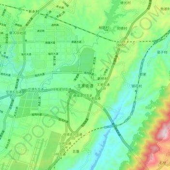
Name: 王家街道 topographic map, elevation, terrain.
Location: 王家街道, 渝北区, 重庆市, 中国 (29.73310 106.65585 29.81310 106.73585)
Average elevation: 1,237 ft
Minimum elevation: 659 ft
Maximum elevation: 2,651 ft
Other topographic maps
Click on a map to view its topography, its elevation and its terrain.