
Jhajha topographic map
Click on the map to display elevation.
About this map
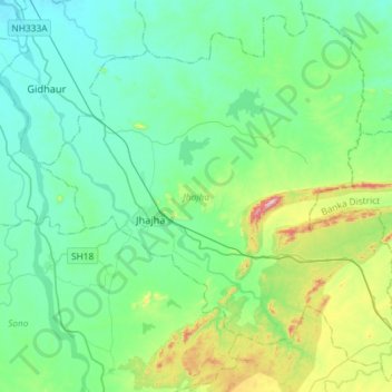
Name: Jhajha topographic map, elevation, terrain.
Location: Jhajha, Jamui District, Bihar, India (24.66067 86.29585 24.90902 86.58578)
Average elevation: 535 ft
Minimum elevation: 262 ft
Maximum elevation: 1,601 ft
Other topographic maps
Click on a map to view its topography, its elevation and its terrain.
Gaya
India > Bihar > Gaya Town C.D.Block
Gaya is connected to the rest of India by roads, rail and airways. The Grand Chord section of the Indian Railways passes through Gaya. Gaya Junction railway station railway station is a major junction station serving the city. Gaya Junction has been redeveloped as Model railway station recently and houses all…
Average elevation: 364 ft
Darbhanga
Darbhanga is located in the northern part of Bihar. It lies between 25.53 degrees - 26.27 degrees N and 85.45 degrees - 86.25 degrees E at an average elevation of 171 feet (52 m). Darbhanga district covers an area of 2,279 sq km. Darbhanga is bounded by Madhubani district in the north, Samastipur district in…
Average elevation: 164 ft
Patna
India > Bihar > Patna Rural
Patna is on the southern bank of the river Ganges. The total area of Patna is 250 km2 (97 sq mi). Of this, the municipal area constitutes 109.218 km2 (42.169 sq mi). The suburban area covers 140.782 km2 (54.356 sq mi). It has an average elevation of 53 m (174 ft). A characteristic feature of the geography of…
Average elevation: 167 ft
Forbesganj
India > Bihar > Forbesganj
Forbesganj is located at 26°18′N 87°15′E / 26.3°N 87.25°E / 26.3; 87.25. It has an average elevation of 46 meters (150 feet). The Nepalese border is only 12 km away.
Average elevation: 200 ft
Arrah
Arrah is located at the elevation of 192 m from the sea level at the bank of Son river, Ganga River and Gangi River. Arrah lies at the confluence of the Ganga and the Son River, other small rivers that flow in the town are Gangi River, Badki Nadi and Chhotki Nadi.
Average elevation: 194 ft
Begusarai
Begusarai is located at 25°25′N 86°08′E / 25.42°N 86.13°E / 25.42; 86.13. It has an average elevation of 41 metres (134 feet). Begusarai lies in North Bihar and is surrounded by Khagaria in the northeast, Munger in the southeast, Patna in the west, and Samastipur in the northwest.
Average elevation: 135 ft
Manihari
Manihari is located at 25°21′N 87°38′E / 25.35°N 87.63°E / 25.35; 87.63. It has an average elevation of 31 m (101 feet). This place is well known for the Manihari ghat, which connects it to Sakrigali Ghaat, which is situated on the southern bank of the River Ganges.
Average elevation: 92 ft
Patna
India > Bihar > Patna Rural
Patna is on the southern bank of the river Ganges. The total area of Patna is 250 km2 (97 sq mi). The municipal area constitutes 109.218 km2 (42.169 sq mi). The suburban area covers 140.782 km2 (54.356 sq mi). It has an average elevation of 53 m (174 ft). A characteristic feature of the geography of Patna is…
Average elevation: 167 ft
Patna
India > Bihar > Patna Rural
Patna is on the southern bank of the river Ganges. The total area of Patna is 250 km2 (97 sq mi). Of this, the municipal area constitutes 109.218 km2 (42.169 sq mi). The suburban area covers 140.782 km2 (54.356 sq mi). It has an average elevation of 53 m (174 ft). A characteristic feature of the geography of…
Average elevation: 167 ft
Muzaffarpur
Muzaffarpur is located at 26°07′N 85°24′E / 26.12°N 85.4°E / 26.12; 85.4. The city lies in a highly active seismic zone of India. In the disastrous earthquake on 15 January 1934, much of the town suffered severe damage and many people died. It has an average elevation of 47 meters (154 feet).…
Average elevation: 177 ft
Patna
India > Bihar > Patna Rural
Patna is on the southern bank of the river Ganges. The total area of Patna is 250 km2 (97 sq mi). The municipal area constitutes 109.218 km2 (42.169 sq mi). The suburban area covers 140.782 km2 (54.356 sq mi). It has an average elevation of 53 m (174 ft). A characteristic feature of the geography of Patna is…
Average elevation: 167 ft
Patna
India > Bihar > Patna Rural
Patna is on the southern bank of the river Ganges. The total area of Patna is 250 km2 (97 sq mi). The municipal area constitutes 109.218 km2 (42.169 sq mi). The suburban area covers 140.782 km2 (54.356 sq mi). It has an average elevation of 53 m (174 ft). A characteristic feature of the geography of Patna is…
Average elevation: 167 ft
Forbesganj
India > Bihar > Forbesganj
Forbesganj is located at 26°18′N 87°15′E / 26.3°N 87.25°E / 26.3; 87.25. It has an average elevation of 46 meters (150 feet). The Nepalese border is only 12 km away.
Average elevation: 200 ft
Begusarai
Begusarai is located at 25°25′N 86°08′E / 25.42°N 86.13°E / 25.42; 86.13. It has an average elevation of 41 metres (134 feet). Begusarai lies in North Bihar and is surrounded by Khagaria in the northeast, Munger in the southeast, Patna in the west, and Samastipur in the northwest.
Average elevation: 135 ft