
Missouri topographic map
Interactive map
Click on the map to display elevation.
Missouri
Missouri's topography is marked by a diverse array of landforms that contribute to its unique landscape. The state is characterized by four main physiographic regions: the Ozark Plateau, Dissected Till Plains, Mississippi Alluvial Plain, and the Osage Plains. The Ozark Plateau, located in the south, features rolling hills, steep ridges, and valleys, with elevations peaking at Taum Sauk Mountain, the highest point in Missouri at 1,772 feet. In contrast, the Dissected Till Plains to the north present a more gently rolling terrain shaped by ancient glacial activity, rich in fertile soils ideal for agriculture. Meanwhile, the Mississippi Alluvial Plain in the southeast is characterized by flat, fertile floodplains and wetlands, created by the meandering Mississippi River, which defines much of Missouri's eastern border. The state's terrain supports a variety of ecosystems, from the oak-hickory forests of the hills to the prairie grasslands of the plains.
About this map
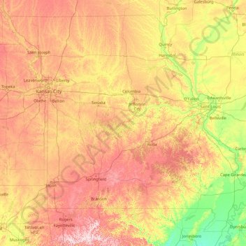
Name: Missouri topographic map, elevation, terrain.
Location: Missouri, United States (35.99572 -95.77414 40.61363 -89.09884)
Average elevation: 827 ft
Minimum elevation: 213 ft
Maximum elevation: 2,388 ft
United States trails, hiking, mountain biking, running and outdoor activities
Other topographic maps
Click on a map to view its topography, its elevation and its terrain.
San Francisco Bay Area
United States > California > San Francisco
The San Francisco Bay Area is characterized by a diverse and dynamic topography shaped by geological processes over millions of years. This region features a combination of coastal plains, steep hills, and rugged mountains, all influenced by the tectonic activity associated with the nearby San Andreas Fault…
Average elevation: 371 ft
Palm Harbor
United States > Florida > Pinellas County
Palm Harbor is characterized by its unique topography, which features a relatively rare hilly landscape for the region. Unlike much of the surrounding areas in Pinellas County, which are predominantly flat, Palm Harbor includes elevations that can reach up to about 75 feet above sea level. This elevation gives…
Average elevation: 30 ft
Baltimore
United States > Maryland > Baltimore
Baltimore is in north-central Maryland on the Patapsco River close to where it empties into the Chesapeake Bay. The city is also located on the fall line between the Piedmont Plateau and the Atlantic coastal plain, which divides Baltimore into "lower city" and "upper city". The city's elevation ranges from sea…
Average elevation: 213 ft
Appalachian Mountains
United States > North Carolina > Yancey County
The Appalachian Mountains (French: Appalaches), often called the Appalachians, are a system of mountains in eastern to northeastern North America. The Appalachians first formed roughly 480 million years ago during the Ordovician Period. They once reached elevations similar to those of the Alps and the Rocky…
Average elevation: 4,800 ft
Central Park
United States > New York > New York County > New York
In June 1856, Fernando Wood appointed a "consulting board" of seven people, headed by author Washington Irving, to inspire public confidence in the proposed development. Wood hired military engineer Egbert Ludovicus Viele as the park's chief engineer, tasking him with a topographical survey of the site. The…
Average elevation: 85 ft
Bridal Veil Falls-Lower East Cascade
United States > Washington > Snohomish County
Average elevation: 2,037 ft
Appalachian Mountains
United States > North Carolina > Yancey County
The Appalachian Mountains (French: Appalaches), often called the Appalachians, are a system of mountains in eastern to northeastern North America. The Appalachians first formed roughly 480 million years ago during the Ordovician Period. They once reached elevations similar to those of the Alps and the Rocky…
Average elevation: 4,800 ft
Crescent City
United States > California > Del Norte County
The topography of the sea floor surrounding Crescent City has the effect of focusing tsunamis. According to researchers at Humboldt State University and the University of Southern California, the city experienced tsunami conditions 31 times between the years 1933 and 2008. Although many of these incidents were…
Average elevation: 102 ft
Crested Butte
United States > Colorado > Gunnison County
Crested Butte is located in north-central Gunnison County on the west side of the valley of the Slate River, along Coal Creek. Colorado State Highway 135 runs south from Crested Butte 27 miles (43 km) to Gunnison, the county seat. According to the United States Census Bureau, the town of Crested Butte has a…
Average elevation: 9,180 ft
Fort Edward Feeder Canal
United States > New York > Washington County > Village of Fort Edward
Average elevation: 187 ft
Central Park
United States > New York > New York County > New York
In June 1856, Fernando Wood appointed a "consulting board" of seven people, headed by author Washington Irving, to inspire public confidence in the proposed development. Wood hired military engineer Egbert Ludovicus Viele as the park's chief engineer, tasking him with a topographical survey of the site. The…
Average elevation: 85 ft
Virginia Beach
United States > Virginia > Virginia Beach
According to the United States Census Bureau, the city has a total area of 497 square miles (1,290 km2), of which 249 square miles (640 km2) is land and 248 square miles (640 km2) (49.9%) is water. It is the largest city in Virginia by total area and third-largest city land area. The average elevation is 12…
Average elevation: 7 ft
Evergreen
United States > Colorado > Jefferson County
Evergreen sits at an elevation of 7,220 feet (2,200 m) in the Rocky Mountains, 19 miles west of Denver, Colorado. Its addresses are oriented according to the Street_system_of_Denver.
Average elevation: 7,575 ft
Mount Rushmore
United States > South Dakota > Pennington County
Mount Rushmore National Memorial is centered on a colossal sculpture carved into the granite face of Mount Rushmore (Lakota: Tȟuŋkášila Šákpe, or Six Grandfathers) in the Black Hills near Keystone, South Dakota. Sculptor Gutzon Borglum created the sculpture's design and oversaw the project's execution…
Average elevation: 5,125 ft
Buckhout Corners
United States > New York > Westchester County > Village of Briarcliff Manor
Average elevation: 367 ft
Mauna Loa
United States > Hawaii > Hawaiʻi County
Mauna Loa is the largest subaerial and second largest overall volcano in the world (behind Tamu Massif), covering a land area of 5,271 km2 (2,035 sq mi) and spans a maximum width of 120 km (75 mi). Consisting of approximately 65,000 to 80,000 km3 (15,600 to 19,200 cu mi) of solid rock, it makes up more than…
Average elevation: 13,245 ft
Port Charlotte
United States > Florida > Charlotte County
Port Charlotte is characterized by a predominantly flat and low-lying terrain, typical of Florida’s coastal landscape. The area features a network of waterways, including the Peace River and Charlotte Harbor, which provide ample opportunities for recreational activities like boating and fishing. Elevations…
Average elevation: 13 ft
Blue Ridge Mountains
United States > Virginia > Botetourt County
Although the term "Blue Ridge" is sometimes applied exclusively to the eastern edge or front range of the Appalachian Mountains, the geological definition of the Blue Ridge province extends westward to the Ridge and Valley area, encompassing the Great Smoky Mountains, the Great Balsams, the Roans, the Blacks,…
Average elevation: 1,509 ft
Morganville
United States > Pennsylvania > Montgomery County > Upper Moreland Township > Willow Grove
Average elevation: 266 ft
Boise
United States > Idaho > Ada County
Boise (locally /ˈbɔɪsi/ BOY-see) is the capital and most populous city of the U.S. state of Idaho and is the county seat of Ada County. As of the 2020 census, there were 235,684 people residing in the city. On the Boise River in southwestern Idaho, it is 41 miles (66 km) east of the Oregon border and 110…
Average elevation: 3,412 ft
Fairplay
United States > Colorado > Park County
The historic Town of Fairplay is the Statutory Town that is the county seat and the most populous municipality of Park County, Colorado, United States. The town population was 724 at the 2020 United States Census. Fairplay is located in South Park at an elevation of 9,953 feet (3,034 m). The town is the…
Average elevation: 9,990 ft
Marlboro
United States > New Jersey > Burlington County > Evesham Township > Marlton
Average elevation: 85 ft
Florida Keys
United States > Florida > Monroe County
Tropical cyclones present special dangers and challenges to the entire Keys. Because no area of the islands is more than 20 feet (6.1 m) above sea level (and many are only a few feet elevation), and water surrounds the islands, nearly every neighborhood is subject to flooding as well as hurricane winds. In…
Average elevation: 0 ft
Strawberry Mansion
United States > Pennsylvania > Philadelphia County > Philadelphia
Average elevation: 102 ft
Chadds Ford Township
United States > Pennsylvania > Delaware County > Chadds Ford Township
Average elevation: 331 ft
East Texas
United States > Pennsylvania > Lehigh County > Lower Macungie Township
Average elevation: 413 ft
Coachella Valley
United States > California > Riverside County > Palm Desert
The area is surrounded on the southwest by the Santa Rosa Mountains, by the San Jacinto Mountains to the west, the Little San Bernardino Mountains to the east and San Gorgonio Mountain to the north. These mountains peak at around 11,000 feet (3,400 m) and tend to average between 5,000 and 7,000 feet (1,500 and…
Average elevation: 236 ft
Scottsdale
United States > Arizona > Maricopa County > Scottsdale
The city is in the Salt River Valley, or the "Valley of the Sun," in the northern reaches of the Sonoran Desert. Scottsdale, 31 mi (50 km) long and 11.4 mi (18.3 km) wide at its widest point, shares boundaries with many other municipalities and entities. On the west, Scottsdale is bordered by Phoenix, Paradise…
Average elevation: 1,358 ft
Highlands
United States > North Carolina > Macon County > Highlands
Highlands was founded in 1875 after its two founders, Samuel Truman Kelsey and Clinton Carter Hutchinson, drew lines from Chicago to Savannah and from New Orleans to New York City. They felt that the place where these lines met would eventually become a great trading center and commercial crossroads. Highlands…
Average elevation: 3,576 ft
Jacksonville
United States > Florida > Duval County > Jacksonville
Just south of Jacksonville and north of Saint Augustine is the boundary of where the Floridian Peninsula ends and Continental North America begins; Jacksonville is north of that line. While still in the North American Coastal plain, the topography begins to take on slight Piedmont characteristics. Like the…
Average elevation: 30 ft
Marble Dale
United States > Connecticut > Northwest Hills Planning Region > Washington
Average elevation: 817 ft