
Pachía topographic map
Click on the map to display elevation.
About this map
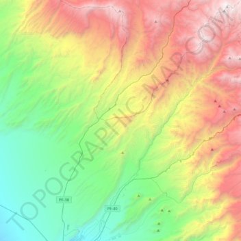
Name: Pachía topographic map, elevation, terrain.
Location: Pachía, Tacna, Perú (-17.98026 -70.18422 -17.57782 -69.86161)
Average elevation: 6,749 ft
Minimum elevation: 2,169 ft
Maximum elevation: 14,226 ft
Other topographic maps
Click on a map to view its topography, its elevation and its terrain.
Tacna
La ciudad de Tacna tiene una altitud promedio de 562 m s. n. m. y por tanto se ubica dentro del ecosistema de la yunga costera (Pulgar Vidal). Se encuentra recorrida de este a oeste por el río Caplina, y sus principales accidentes geográficos son los cerros Intiorko, Arunta y Chastudal. Antiguamente la…
Average elevation: 2,411 ft