
Tataouine topographic map
Interactive map
Click on the map to display elevation.
About this map
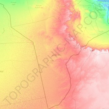
Name: Tataouine topographic map, elevation, terrain.
Location: Tataouine, Tunisia (30.22906 8.35683 33.23475 11.34198)
Average elevation: 968 ft
Minimum elevation: -10 ft
Maximum elevation: 2,343 ft
Wells from aquifers dot the eastern slopes of the pronounced long escarpment climbing gradually from 100 m to 500 m in elevation two provinces north in the south extreme of Gabes Governorate, passing through a thin strip of Medenine and then at the heart of the province ending around a capital city Tripoli, Libya. The ridge attracts variable winter and early spring relief precipitation and little other rain and shares with the rest of the area a hot desert climate (Köppen climate classification BWh) with long, extremely hot summers throughout (see North-south graduation of Tunisian climatic zones), the patchy and infrequent rainfall in winter is greater than the average for the Sahara Desert of which the area forms part. Approximately half of the escarpment exceeds 500 m in the province, the peak within Tunisia being 631 m near the town of Remada on the main road south of Tatouine leading into mid-eastern Libya. The tripoint of the three countries is close to the Libyan town of Ghadames which has surrounding it three airstrips, one of which constitutes an airport and one of which lies in Algeria. Close to the west or south-west border is El Borma Airport and the province has a second, which is for defence and rescue, Remada Air Base.
Other topographic maps
Click on a map to view its topography, its elevation and its terrain.
Kelibia
Tunisia > Nabeul > قليبية الغربية
Kelibia, قليبية الغربية, معتمدية قليبية, Nabeul, Tunisia
Average elevation: 56 ft
Thala
Tunisia > Kasserine > تالة الغربية
Thala, تالة الغربية, معتمدية تالة, Kasserine, 1210, Tunisia
Average elevation: 3,215 ft
قليبية الغربية
قليبية الغربية, معتمدية قليبية, Nabeul, 8090, Tunisia
Average elevation: 49 ft
قصور الساف الرياض
قصور الساف الرياض, معتمدية قصور الساف, Mahdia, Tunisia
Average elevation: 59 ft
Medenine
Tunisia > Médenine > مدنين الجنوبية
Medenine, مدنين الجنوبية, معتمدية مدنين االجنوبية, Médenine, 4100, Tunisia
Average elevation: 348 ft
Djerba Island
Djerba Island, ربانة, معتمدية جربة ميدون, Médenine, Tunisia
Average elevation: 23 ft
Menzel Temime
Tunisia > Nabeul > علي بلهوان
Menzel Temime, علي بلهوان, معتمدية منزل تميم, Nabeul, 8080, Tunisia
Average elevation: 62 ft
جربة حومة السوق
جربة حومة السوق, السواني, معتمدية جربة حومة السوق, Médenine, Tunisia
Average elevation: 33 ft
بوحجلة
Tunisia > Kairouan > بوحجلة المركز
بوحجلة, بوحجلة المركز, معتمدية بوحجلة, Kairouan, 3180, Tunisia
Average elevation: 394 ft
حمام الأنف
Tunisia > Ben Arous > حي محمد علي
حمام الأنف, حي محمد علي, معتمدية حمام الأنف, Ben Arous, Tunisia
Average elevation: 348 ft
Mégrine
Tunisia > Ben Arous > مقرين العليا
Mégrine, مقرين العليا, معتمدية مقرين, Ben Arous, 2033, Tunisia
Average elevation: 36 ft
Sidi Mechreg
Sidi Mechreg, سيدي مشرق, معتمدية سجنان, Bizerte, Tunisia
Average elevation: 151 ft
Kelibia
Tunisia > Nabeul > قليبية الغربية
Kelibia, قليبية الغربية, معتمدية قليبية, Nabeul, 8090, Tunisia
Average elevation: 59 ft
Kairouan
Tunisia > Kairouan > القبلية الجنوبية
Kairouan, القبلية الجنوبية, معتمدية القيروان الجنوبية, Kairouan, 3172, Tunisia
Average elevation: 217 ft
Zaghouan
Tunisia > Zaghouan Governorate > زغوان المدينة
Zaghouan, زغوان المدينة, معتمدية زغوان, Zaghouan Governorate, 1100, Tunisia
Average elevation: 827 ft