
Gilbert Islands topographic map
Interactive map
Click on the map to display elevation.
About this map
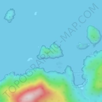
Name: Gilbert Islands topographic map, elevation, terrain.
Location: Gilbert Islands, Southland, New Zealand (-45.60277 166.65391 -45.59817 166.66397)
Average elevation: 190 ft
Minimum elevation: -7 ft
Maximum elevation: 1,693 ft
Other topographic maps
Click on a map to view its topography, its elevation and its terrain.
Mosgiel
New Zealand > Otago > Dunedin City
Mosgiel, Dunedin City, Otago, 9024, New Zealand
Average elevation: 180 ft
Dragons Teeth
New Zealand > Tasman > Tasman District
Dragons Teeth, Tasman District, Tasman, New Zealand
Average elevation: 3,983 ft
Sutherland Falls
New Zealand > Southland > Southland District > Fiordland Community
Sutherland Falls, Fiordland Community, Southland District, Southland, New Zealand
Average elevation: 3,301 ft
Mount Blanc
Mount Blanc, Marlborough, New Zealand
Average elevation: 2,700 ft
Ohinepaka Bay
New Zealand > Canterbury > Christchurch City > Banks Peninsula Community > Wainui
Ohinepaka Bay, Wainui, Banks Peninsula Community, Christchurch City, Canterbury, 7582, New Zealand
Average elevation: 308 ft
Great Barrier Island
Great Barrier Island, Auckland, 0991, New Zealand
Average elevation: 102 ft
Pitt Island (Rangiauria)
Pitt Island (Rangiauria), Chatham Islands, New Zealand
Average elevation: 33 ft
Rakiura Rocks
New Zealand > Marlborough > Marlborough District
Rakiura Rocks, Marlborough District, Marlborough, New Zealand
Average elevation: 33 ft
Pōkeno
New Zealand > Waikato > Waikato District
Pōkeno, Waikato District, Waikato, 2472, New Zealand
Average elevation: 217 ft
Woodend Beach
New Zealand > Canterbury > Waimakariri District
Woodend Beach, Waimakariri District, Canterbury, 7612, New Zealand
Average elevation: 10 ft
Cascade Kauri Picture Frame
New Zealand > Auckland > Waitakere Ranges
Cascade Kauri Picture Frame, Falls Road, Waitākere Ranges, Auckland, 0816, New Zealand
Average elevation: 463 ft
Pyramids
New Zealand > Otago > Dunedin City
Pyramids, Dunedin City, Otago, New Zealand
Average elevation: 171 ft
Gisborne
New Zealand > Gisborne > Gisborne District
Gisborne, Gisborne District, Gisborne, 4010, New Zealand
Average elevation: 230 ft
Mount Livingstone
New Zealand > Canterbury > Mackenzie District
Mount Livingstone, Mackenzie District, Canterbury, New Zealand
Average elevation: 6,381 ft
Selwyn District
Selwyn District, Canterbury, New Zealand
Average elevation: 2,228 ft
Punakaiki
New Zealand > West Coast > Buller District
Punakaiki, Buller District, West Coast, 7873, New Zealand
Average elevation: 230 ft
Days Bay
New Zealand > Wellington > Lower Hutt
Days Bay, Lower Hutt, Wellington, 5013, New Zealand
Average elevation: 243 ft
Upper Hutt
New Zealand > Wellington > Upper Hutt City
Upper Hutt, Upper Hutt City, Wellington, 5218, New Zealand
Average elevation: 889 ft
Snow Bowl
New Zealand > Taranaki > Stratford District
Snow Bowl, Stratford District, Taranaki, New Zealand
Average elevation: 4,813 ft
Central Otago
New Zealand > Otago > Central Otago District > Vincent Community
Central Otago, Vincent Community, Central Otago District, Otago, 9035, New Zealand
Average elevation: 3,068 ft
Hahei Beach
New Zealand > Waikato > Thames-Coromandel District > Hahei
Hahei Beach, Hahei, Thames-Coromandel District, Waikato, New Zealand
Average elevation: 95 ft
Tikorangi
New Zealand > Bay of Plenty > Whakatāne District
Tikorangi, Whakatāne District, Bay of Plenty, New Zealand
Average elevation: 1,588 ft
Lake Panorama
New Zealand > Auckland > Henderson-Massey
Lake Panorama, Western Heights, Henderson-Massey, Auckland, New Zealand
Average elevation: 171 ft
Mana Island
New Zealand > Wellington > Porirua City > Porirua
Mana Island, Porirua, Porirua City, Wellington, New Zealand
Average elevation: 52 ft
Kaimai Range
New Zealand > Bay of Plenty > Western Bay of Plenty District
Kaimai Range, Western Bay of Plenty District, Bay of Plenty, New Zealand
Average elevation: 1,952 ft
Putāruru
New Zealand > Waikato > South Waikato District
Putāruru, South Waikato District, Waikato, 3411, New Zealand
Average elevation: 545 ft
Waiari Reserve
New Zealand > Auckland > Papakura
Waiari Reserve, Conifer Grove, Papakura, Auckland, New Zealand
Average elevation: 39 ft
Ōakura
New Zealand > Taranaki > New Plymouth District
Ōakura, New Plymouth District, Taranaki, 4314, New Zealand
Average elevation: 243 ft
Shalamar Reserve
New Zealand > Canterbury > Christchurch City > Christchurch
Shalamar Reserve, Cashmere, Christchurch, Christchurch City, Canterbury, New Zealand
Average elevation: 157 ft
Remus
New Zealand > Canterbury > Selwyn District
Remus, Selwyn District, Canterbury, New Zealand
Average elevation: 2,034 ft
Whitianga
New Zealand > Bay of Plenty > Ōpōtiki District
Whitianga, Ōpōtiki District, Bay of Plenty, 3162, New Zealand
Average elevation: 138 ft
Cape Kidnappers / Te Kauwae-a-Māui
New Zealand > Hawke's Bay > Hastings District
Cape Kidnappers / Te Kauwae-a-Māui, Hastings District, Hawke's Bay, New Zealand
Average elevation: 52 ft
Wilson's Beach
New Zealand > Auckland > Ōrākei
Wilson's Beach, Ōrākei, Auckland, New Zealand
Average elevation: 69 ft
Douglas Pass
New Zealand > West Coast > Westland District
Douglas Pass, Westland District, West Coast, New Zealand
Average elevation: 5,259 ft
Little River
Little River, Canterbury, New Zealand, Whale Island
Average elevation: 30 ft
Waikato District
Waikato District, Waikato, New Zealand
Average elevation: 220 ft
Coastal-Burwood Community
New Zealand > Canterbury > Christchurch City
Coastal-Burwood Community, Christchurch City, Canterbury, New Zealand
Average elevation: 20 ft
Bridal Veil Falls
New Zealand > Waikato > Rotorua Lakes District
Bridal Veil Falls, Rotorua Lakes District, Waikato, New Zealand
Average elevation: 1,158 ft
Lake Windermere
New Zealand > West Coast > Westland District
Lake Windermere, Westland District, West Coast, New Zealand
Average elevation: 13 ft
Round Knob
New Zealand > Manawatu-Whanganui > Tararua District
Round Knob, Tararua District, Manawatū-Whanganui, New Zealand
Average elevation: 784 ft