
Quetta topographic map
Interactive map
Click on the map to display elevation.
About this map
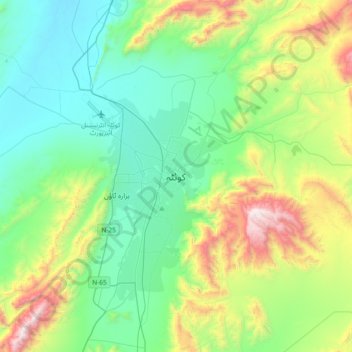
Name: Quetta topographic map, elevation, terrain.
Location: Quetta, Balochistan, 87300, Pakistan (30.03577 66.85724 30.35577 67.17724)
Average elevation: 6,457 ft
Minimum elevation: 5,046 ft
Maximum elevation: 10,433 ft
Quetta (/ˈkwɛtə/; Urdu: کوئٹہ; [ˈkweːʈə] (listen); Pashto: کوټه) is the tenth most populous city in Pakistan with a population of over 1.1 million. It is situated in south-west of the country close to the International border with Afghanistan. It is the capital of the province of Balochistan where it is the largest city. Quetta is at an average elevation of 1,680 metres (5,510 feet) above sea level, making it Pakistan's only high-altitude major city. The city is known as the "Fruit Garden of Pakistan" due to the numerous fruit orchards in and around it, and the large variety of fruits and dried fruit products produced there.
Other topographic maps
Click on a map to view its topography, its elevation and its terrain.
Khuzdar
Pakistan > Balochistan > Khuzdar District
Khuzdar, Khuzdar Tehsil, Khuzdar District, Qalat Division, Balochistan, 89100, Pakistan
Average elevation: 4,649 ft
Quetta District
Quetta District, Quetta Division, Balochistan, Pakistan
Average elevation: 5,072 ft
Mud Volcano
Pakistan > Balochistan > Gwadar District
Mud Volcano, Ormara Tehsil, Gwadar District, Balochistan, Pakistan
Average elevation: 39 ft
Khuzdar Tehsil
Pakistan > Balochistan > Khuzdar District
Khuzdar Tehsil, Khuzdar District, Qalat Division, Balochistan, 89100, Pakistan
Average elevation: 3,232 ft
Chagai District
Chagai District, Balochistan, Pakistan
Average elevation: 3,015 ft
Hanna Lake
Pakistan > Balochistan > Quetta
Hanna Lake, Quetta, Balochistan, 87300, Pakistan
Average elevation: 6,421 ft
Ziarat Park
Pakistan > Balochistan > Quetta
Ziarat Park, Habib Kili, Quetta, Balochistan, 87300, Pakistan
Average elevation: 5,505 ft
Hub
Pakistan > Balochistan > Hub
Hub, Lasbela District, Balochistan, 90250, Pakistan
Average elevation: 180 ft
Gharo
Pakistan > Balochistan > Gharo
Gharo, Khuzdar District, Balochistan, Pakistan
Average elevation: 4,925 ft
Dalbandin
Pakistan > Balochistan > Dalbandin
Dalbandin, Chagai District, Balochistan, 95100, Pakistan
Average elevation: 2,825 ft
Qila Saifullah
Pakistan > Balochistan > Qila Saifullah
Qila Saifullah, Qila Saifullāh District, Balochistan, Pakistan
Average elevation: 5,223 ft
Gaddani
Pakistan > Balochistan > Gaddani
Gaddani, Lasbela District, Balochistan, 90300, Pakistan
Average elevation: 66 ft
Lasbela District
Lasbela District, Balochistan, Pakistan
Average elevation: 804 ft
Gwādar
Pakistan > Balochistan > Gwadar District
Gwādar, Gwadar District, Balochistan, Pakistan
Average elevation: 20 ft
Khuzdar District
Khuzdar District, Balochistan, Pakistan
Average elevation: 2,602 ft