
Tuti topographic map
Click on the map to display elevation.
About this map
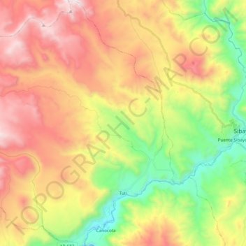
Name: Tuti topographic map, elevation, terrain.
Location: Tuti, Caylloma, Arequipa, Perú (-15.57271 -71.68114 -15.38908 -71.50993)
Average elevation: 14,449 ft
Minimum elevation: 12,080 ft
Maximum elevation: 17,070 ft
Other topographic maps
Click on a map to view its topography, its elevation and its terrain.
Ampato
El Ampato (del aimara jamp'atu, 'sapo') es un volcán inactivo localizado en la Cordillera de Ampato al sur del Perú, en el distrito de Lluta. Tiene una altitud de 6.290 m s. n. m. Cerca de la cumbre de este nevado fue descubierto un cadáver congelado en septiembre de 1995 por el arqueólogo de montaña…
Average elevation: 18,976 ft
El Pedregal
El Pedregal es una localidad peruana, capital del distrito de Majes, ubicado en la provincia de Caylloma, en el departamento de Arequipa. Se encuentra a una altitud de 1410 m s. n. m. Tenía una población de 2573 hab. en 1993.
Average elevation: 4,554 ft
Mirador Cruz del Condor
Perú > Arequipa > Cabanaconde > Cabanaconde > San Miguel
Average elevation: 11,657 ft
Valle del Colca
Perú > Arequipa > Choco > Soro
El Altiplano en el Colca está representado por una extensa meseta que se desarrolla a altitudes entre 4000 y 4500 m s. n. m.. Ésta es una superficie casi llana o suavemente ondulada, sobre la cual destacan cerros y volcanes que sobrepasan los 5000 m s. n. m.. Es en estas superficies donde sobresalen volcanes…
Average elevation: 10,397 ft
Pampa de los Camarones
Perú > Arequipa > Sachaca > Guillermo Torreblanca > Pampa de los Camarones
Average elevation: 7,536 ft
Ciudad Satélite
Perú > Arequipa > José Luis Bustamante y Rivero > Ciudad Satélite
Average elevation: 7,785 ft
Manantial de Chancharay
Perú > Arequipa > Aplao > Hacienda La Cabecera > Yupanqui
Average elevation: 2,402 ft