
Make a donation
Gear up for your next adventure:
As an Amazon Associate, this site earns from qualifying purchases at no extra cost to you.
Nantucket topographic map
Click on the map to display elevation.
Make a donation
Gear up for your next adventure:
As an Amazon Associate, this site earns from qualifying purchases at no extra cost to you.
About this map
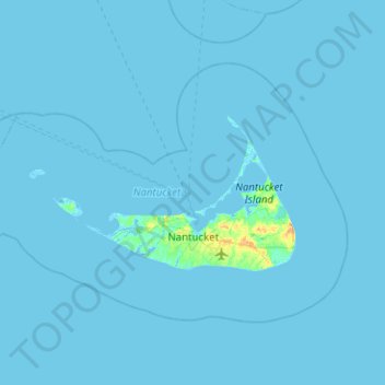
Name: Nantucket topographic map, elevation, terrain.
Location: Nantucket, Massachusetts, United States (41.18886 -70.39736 41.44339 -69.89364)
Average elevation: 3 ft
Minimum elevation: -20 ft
Maximum elevation: 92 ft
Massachusetts trails, hiking, mountain biking, running and outdoor activities
Make a donation
Gear up for your next adventure:
As an Amazon Associate, this site earns from qualifying purchases at no extra cost to you.
Other topographic maps
Click on a map to view its topography, its elevation and its terrain.
Boston
United States > Massachusetts > Suffolk County > Boston
Boston has an area of 89.63 sq mi (232.1 km2)—48.4 sq mi (125.4 km2) (54%) of land and41.2 sq mi (106.7 km2) (46%) of water. The city's official elevation, as measured at Logan International Airport, is 19 ft (5.8 m) above sea level. The highest point in Boston is Bellevue Hill at 330 ft (100 m) above sea…
Average elevation: 85 ft
Make a donation
Gear up for your next adventure:
As an Amazon Associate, this site earns from qualifying purchases at no extra cost to you.
North Sunderland
United States > Massachusetts > Franklin County > Sunderland
Average elevation: 328 ft
Make a donation
Gear up for your next adventure:
As an Amazon Associate, this site earns from qualifying purchases at no extra cost to you.
Make a donation
Gear up for your next adventure:
As an Amazon Associate, this site earns from qualifying purchases at no extra cost to you.
Weymouth Woods
United States > Massachusetts > Norfolk County > Weymouth > South Weymouth > Pine Grove
Average elevation: 161 ft
Make a donation
Gear up for your next adventure:
As an Amazon Associate, this site earns from qualifying purchases at no extra cost to you.
Berkshire Heights
United States > Massachusetts > Berkshire County > Great Barrington
Average elevation: 797 ft
Make a donation
Gear up for your next adventure:
As an Amazon Associate, this site earns from qualifying purchases at no extra cost to you.
Make a donation
Gear up for your next adventure:
As an Amazon Associate, this site earns from qualifying purchases at no extra cost to you.
Hadwen Park
United States > Massachusetts > Worcester County > Worcester > Heard Street
Average elevation: 545 ft
Make a donation
Gear up for your next adventure:
As an Amazon Associate, this site earns from qualifying purchases at no extra cost to you.
Marshfield Center
United States > Massachusetts > Plymouth County > Marshfield
Average elevation: 112 ft
Mill Pond
United States > Massachusetts > Plymouth County > Duxbury > Miles Standish Park
Average elevation: 66 ft
Make a donation
Gear up for your next adventure:
As an Amazon Associate, this site earns from qualifying purchases at no extra cost to you.
Make a donation
Gear up for your next adventure:
As an Amazon Associate, this site earns from qualifying purchases at no extra cost to you.
Daley Corner
United States > Massachusetts > Bristol County > Easton > North Easton
Average elevation: 154 ft
North Chelmsford
United States > Massachusetts > Middlesex County > Chelmsford
Average elevation: 135 ft
Make a donation
Gear up for your next adventure:
As an Amazon Associate, this site earns from qualifying purchases at no extra cost to you.
Make a donation
Gear up for your next adventure:
As an Amazon Associate, this site earns from qualifying purchases at no extra cost to you.
Kettle Cove Village
United States > Massachusetts > Essex County > Manchester-by-the-Sea
Average elevation: 59 ft
Risingdale
United States > Massachusetts > Berkshire County > Great Barrington
Average elevation: 909 ft
Brayton Hill
United States > Massachusetts > Berkshire County > North Adams
Average elevation: 1,053 ft
Make a donation
Gear up for your next adventure:
As an Amazon Associate, this site earns from qualifying purchases at no extra cost to you.
Camp Kiwanis
United States > Massachusetts > Middlesex County > Tyngsborough
Average elevation: 217 ft
Make a donation
Gear up for your next adventure:
As an Amazon Associate, this site earns from qualifying purchases at no extra cost to you.
Brookside
United States > Massachusetts > Berkshire County > Great Barrington
Average elevation: 932 ft
Make a donation
Gear up for your next adventure:
As an Amazon Associate, this site earns from qualifying purchases at no extra cost to you.
Make a donation
Gear up for your next adventure:
As an Amazon Associate, this site earns from qualifying purchases at no extra cost to you.
Blackwater River
United States > Massachusetts > Essex County > Salisbury > Salisbury Beach
Average elevation: 13 ft
Make a donation
Gear up for your next adventure:
As an Amazon Associate, this site earns from qualifying purchases at no extra cost to you.
Northbridge Center
United States > Massachusetts > Worcester County > Northbridge
Average elevation: 407 ft
Make a donation
Gear up for your next adventure:
As an Amazon Associate, this site earns from qualifying purchases at no extra cost to you.
Freshwater Cove Village
United States > Massachusetts > Essex County > Gloucester
Average elevation: 59 ft
Make a donation
Gear up for your next adventure:
As an Amazon Associate, this site earns from qualifying purchases at no extra cost to you.
Make a donation
Gear up for your next adventure:
As an Amazon Associate, this site earns from qualifying purchases at no extra cost to you.
Kenberma
United States > Massachusetts > Plymouth County > Hull > Nantasket Beach
Average elevation: 7 ft
Make a donation
Gear up for your next adventure:
As an Amazon Associate, this site earns from qualifying purchases at no extra cost to you.
Make a donation
Gear up for your next adventure:
As an Amazon Associate, this site earns from qualifying purchases at no extra cost to you.
Source Is Shapefile From Town
United States > Massachusetts > Bristol County > Mansfield > Robinsonville
Average elevation: 164 ft
Make a donation
Gear up for your next adventure:
As an Amazon Associate, this site earns from qualifying purchases at no extra cost to you.
Crow Hill Ledges
United States > Massachusetts > Worcester County > Westminster
Average elevation: 961 ft
South Hadley Falls
United States > Massachusetts > Hampshire County > South Hadley
Average elevation: 164 ft
Make a donation
Gear up for your next adventure:
As an Amazon Associate, this site earns from qualifying purchases at no extra cost to you.
Little River Marshes
United States > Massachusetts > Essex County > Gloucester > West Gloucester
Average elevation: 89 ft
Hephzibah Heights
United States > Massachusetts > Berkshire County > Monterey
Average elevation: 1,499 ft
Charles River Village
United States > Massachusetts > Norfolk County > Needham
Average elevation: 161 ft
Make a donation
Gear up for your next adventure:
As an Amazon Associate, this site earns from qualifying purchases at no extra cost to you.
Make a donation
Gear up for your next adventure:
As an Amazon Associate, this site earns from qualifying purchases at no extra cost to you.