
Make a donation
Gear up for your next adventure:
As an Amazon Associate, this site earns from qualifying purchases at no extra cost to you.
Dixie National Forest topographic map
Click on the map to display elevation.
Make a donation
Gear up for your next adventure:
As an Amazon Associate, this site earns from qualifying purchases at no extra cost to you.
Dixie National Forest
Elevations vary from 2,800 feet (850 m) above sea level near St. George, Utah to 11,322 feet (3,451 m) at Blue Bell Knoll on Boulder Mountain. The southern rim of the Great Basin, near the Colorado River, provides spectacular scenery. Colorado River canyons are made up of multi-colored cliffs and steep-walled gorges.
Make a donation
Gear up for your next adventure:
As an Amazon Associate, this site earns from qualifying purchases at no extra cost to you.
About this map
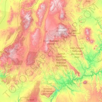
Name: Dixie National Forest topographic map, elevation, terrain.
Location: Dixie National Forest, Utah, United States (37.21645 -114.05285 38.16424 -111.35358)
Average elevation: 5,676 ft
Minimum elevation: 1,407 ft
Maximum elevation: 12,001 ft
Utah trails, hiking, mountain biking, running and outdoor activities
Make a donation
Gear up for your next adventure:
As an Amazon Associate, this site earns from qualifying purchases at no extra cost to you.
Other topographic maps
Click on a map to view its topography, its elevation and its terrain.
Make a donation
Gear up for your next adventure:
As an Amazon Associate, this site earns from qualifying purchases at no extra cost to you.
Make a donation
Gear up for your next adventure:
As an Amazon Associate, this site earns from qualifying purchases at no extra cost to you.
Make a donation
Gear up for your next adventure:
As an Amazon Associate, this site earns from qualifying purchases at no extra cost to you.
Make a donation
Gear up for your next adventure:
As an Amazon Associate, this site earns from qualifying purchases at no extra cost to you.
Make a donation
Gear up for your next adventure:
As an Amazon Associate, this site earns from qualifying purchases at no extra cost to you.
Salt Lake City
United States > Utah > Salt Lake County > Salt Lake City
Salt Lake City has an area of 110.4 square miles (286 km2) and an average elevation of 4,327 feet (1,319 m) above sea level. The lowest point within the boundaries of the city is 4,210 feet (1,280 m) near the Jordan River and the Great Salt Lake, and the highest is Grandview Peak, at 9,410 feet (2,868 m).
Average elevation: 5,331 ft
Make a donation
Gear up for your next adventure:
As an Amazon Associate, this site earns from qualifying purchases at no extra cost to you.
Make a donation
Gear up for your next adventure:
As an Amazon Associate, this site earns from qualifying purchases at no extra cost to you.
Make a donation
Gear up for your next adventure:
As an Amazon Associate, this site earns from qualifying purchases at no extra cost to you.
Make a donation
Gear up for your next adventure:
As an Amazon Associate, this site earns from qualifying purchases at no extra cost to you.
Make a donation
Gear up for your next adventure:
As an Amazon Associate, this site earns from qualifying purchases at no extra cost to you.
Little Cottonwood Creek Valley
United States > Utah > Salt Lake County > Cottonwood Heights
Average elevation: 4,715 ft
Make a donation
Gear up for your next adventure:
As an Amazon Associate, this site earns from qualifying purchases at no extra cost to you.
Gunlock
United States > Utah > Washington County
The community lies on the Santa Clara River, northwest of the Red Mountains along local roads, northwest of the city of St. George, the county seat of Washington County. Its elevation is 3,658 feet (1,115 m). Although Gunlock is unincorporated, it has a post office, with the ZIP code of 84733.
Average elevation: 3,970 ft
Make a donation
Gear up for your next adventure:
As an Amazon Associate, this site earns from qualifying purchases at no extra cost to you.
Grouse Creek
United States > Utah > Box Elder County
Grouse Creek (also Cookesville) is an unincorporated community in the nearly unpopulated northwestern region of Box Elder County, Utah, United States, near the Idaho and Nevada borders. The community lies along unpaved roads north of State Route 30 in the Grouse Creek Mountains. Its elevation is 5,331 feet…
Average elevation: 5,423 ft
Brighton
United States > Utah > Salt Lake County
Brighton has a high-altitude cold continental climate (Köppen Dsb/Dsc), with dry summers and very snowy winters.
Average elevation: 9,357 ft
Make a donation
Gear up for your next adventure:
As an Amazon Associate, this site earns from qualifying purchases at no extra cost to you.
Silver Reef
United States > Utah > Washington County > Leeds
Silver Reef is close to the western border of the Colorado Plateau and about 15 miles (24 km) northeast of St. George and 1 mile (1.6 km) west of Leeds. Dixie National Forest, Leeds Creek, the White Reef, and the Pine Valley Mountain Wilderness lie directly west of Silver Reef. The Pine Valley Mountain…
Average elevation: 3,888 ft
Make a donation
Gear up for your next adventure:
As an Amazon Associate, this site earns from qualifying purchases at no extra cost to you.
Make a donation
Gear up for your next adventure:
As an Amazon Associate, this site earns from qualifying purchases at no extra cost to you.
Make a donation
Gear up for your next adventure:
As an Amazon Associate, this site earns from qualifying purchases at no extra cost to you.
Parleys Canyon
United States > Utah > Salt Lake County > Millcreek
Parleys Canyon is a canyon located in the U.S. state of Utah. The canyon provides the route of Interstate 80 (I-80) (and previously the Lincoln Highway, U.S. Route 40, and a railroad) up the western slope of the Wasatch Mountains and is a relatively wide, straight canyon other than near its mouth. The mountain…
Average elevation: 5,174 ft
Make a donation
Gear up for your next adventure:
As an Amazon Associate, this site earns from qualifying purchases at no extra cost to you.
Make a donation
Gear up for your next adventure:
As an Amazon Associate, this site earns from qualifying purchases at no extra cost to you.
Park City
United States > Utah > Summit County > Park City
In the summertime, many valley residents of the Wasatch Front visit the town to escape high temperatures. Park City is usually cooler than Salt Lake City as it lies mostly higher than 7,000 feet (2,100 m) above sea level, while Salt Lake City is situated at an elevation of about 4,300 feet (1,300 m).
Average elevation: 7,595 ft
Make a donation
Gear up for your next adventure:
As an Amazon Associate, this site earns from qualifying purchases at no extra cost to you.
Make a donation
Gear up for your next adventure:
As an Amazon Associate, this site earns from qualifying purchases at no extra cost to you.
Make a donation
Gear up for your next adventure:
As an Amazon Associate, this site earns from qualifying purchases at no extra cost to you.
Granite Park
United States > Utah > Salt Lake County > Sandy > Granite Crest
Average elevation: 5,033 ft
Make a donation
Gear up for your next adventure:
As an Amazon Associate, this site earns from qualifying purchases at no extra cost to you.
Make a donation
Gear up for your next adventure:
As an Amazon Associate, this site earns from qualifying purchases at no extra cost to you.
Make a donation
Gear up for your next adventure:
As an Amazon Associate, this site earns from qualifying purchases at no extra cost to you.
Make a donation
Gear up for your next adventure:
As an Amazon Associate, this site earns from qualifying purchases at no extra cost to you.