
Make a donation
Gear up for your next adventure:
As an Amazon Associate, this site earns from qualifying purchases at no extra cost to you.
Johnson topographic map
Click on the map to display elevation.
Make a donation
Gear up for your next adventure:
As an Amazon Associate, this site earns from qualifying purchases at no extra cost to you.
About this map
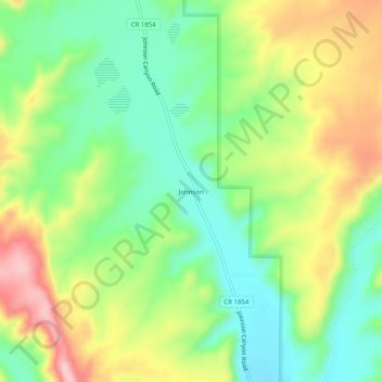
Name: Johnson topographic map, elevation, terrain.
Location: Johnson, Utah, United States (37.06643 -112.38941 37.10643 -112.34941)
Average elevation: 5,453 ft
Minimum elevation: 5,177 ft
Maximum elevation: 5,863 ft
Utah trails, hiking, mountain biking, running and outdoor activities
Make a donation
Gear up for your next adventure:
As an Amazon Associate, this site earns from qualifying purchases at no extra cost to you.
Other topographic maps
Click on a map to view its topography, its elevation and its terrain.
Lake Powell
United States > Utah > San Juan County
Concrete placement started around the clock on June 17, 1960. The last bucket of concrete was poured on September 13, 1963. Over 5 million cubic yards (4,000,000 m³) of concrete make up Glen Canyon Dam. The dam is 710 feet (216 m) high and the surface elevation of the water at full-pool is approximately 3700…
Average elevation: 5,102 ft
Dixie National Forest
Elevations vary from 2,800 feet (850 m) above sea level near St. George, Utah to 11,322 feet (3,451 m) at Blue Bell Knoll on Boulder Mountain. The southern rim of the Great Basin, near the Colorado River, provides spectacular scenery. Colorado River canyons are made up of multi-colored cliffs and steep-walled…
Average elevation: 5,676 ft
Make a donation
Gear up for your next adventure:
As an Amazon Associate, this site earns from qualifying purchases at no extra cost to you.
Utah Lake
United States > Utah > Utah County
Utah Lake is a shallow freshwater lake in the center of Utah County, Utah, United States. It lies in Utah Valley, surrounded by the Provo-Orem metropolitan area. The lake's only river outlet, the Jordan River, is a tributary of the Great Salt Lake. Evaporation accounts for 42% of the lake's outflow, which…
Average elevation: 4,961 ft
Make a donation
Gear up for your next adventure:
As an Amazon Associate, this site earns from qualifying purchases at no extra cost to you.
Eureka
United States > Utah > Juab County
Eureka is located in northern Juab County at 39°57′18″N 112°6′59″W / 39.95500°N 112.11639°W / 39.95500; -112.11639 (39.954974, -112.116364). It sits in the East Tintic Mountains at an elevation of 6,430 feet (1,960 m) above sea level. The northeast boundary of the city is the Utah County…
Average elevation: 6,719 ft
Make a donation
Gear up for your next adventure:
As an Amazon Associate, this site earns from qualifying purchases at no extra cost to you.
Make a donation
Gear up for your next adventure:
As an Amazon Associate, this site earns from qualifying purchases at no extra cost to you.
Make a donation
Gear up for your next adventure:
As an Amazon Associate, this site earns from qualifying purchases at no extra cost to you.
Make a donation
Gear up for your next adventure:
As an Amazon Associate, this site earns from qualifying purchases at no extra cost to you.
Make a donation
Gear up for your next adventure:
As an Amazon Associate, this site earns from qualifying purchases at no extra cost to you.
Make a donation
Gear up for your next adventure:
As an Amazon Associate, this site earns from qualifying purchases at no extra cost to you.
Clarkston
United States > Utah > Cache County
The townsite of Clarkston was laid out in 1864. It was named for Israel Justus Clark, who was an early settler and the first branch president of the Church of Jesus Christ of Latter-day Saints in Clarkston. The settlers originally settled east of modern-day Clarkston in a spot known as the flat. Due to water…
Average elevation: 4,915 ft
Make a donation
Gear up for your next adventure:
As an Amazon Associate, this site earns from qualifying purchases at no extra cost to you.
Make a donation
Gear up for your next adventure:
As an Amazon Associate, this site earns from qualifying purchases at no extra cost to you.
Make a donation
Gear up for your next adventure:
As an Amazon Associate, this site earns from qualifying purchases at no extra cost to you.
Make a donation
Gear up for your next adventure:
As an Amazon Associate, this site earns from qualifying purchases at no extra cost to you.
Make a donation
Gear up for your next adventure:
As an Amazon Associate, this site earns from qualifying purchases at no extra cost to you.
Bicknell
United States > Utah > Wayne County
According to the United States Census Bureau, the town has a total area of 0.62 square miles (1.6 km2), all land. It is situated at an altitude of 7,125 feet (2,172 m) above sea level, in the Rabbit Valley in south-central Utah. The Fremont River flows through the valley, which lies between 11,305-foot (3,446…
Average elevation: 7,152 ft
Scofield Reservoir
United States > Utah > Carbon County
Scofield Reservoir is a 2,815-acre (11.39 km2) reservoir impounded by Scofield Dam, in Carbon County, Utah. Located on the Price River, a tributary of the Green River, Scofield Reservoir is adjacent to northernmost boundary of the Manti–La Sal National Forest. The reservoir sits at an elevation of 7,618 feet…
Average elevation: 7,989 ft
Make a donation
Gear up for your next adventure:
As an Amazon Associate, this site earns from qualifying purchases at no extra cost to you.
Oljato–Monument Valley
United States > Utah > San Juan County
Oljato–Monument Valley is located at 37°0′38″N 110°14′34″W / 37.01056°N 110.24278°W / 37.01056; -110.24278 (37.010556, -110.242778), at an elevation of 1,475 m (4,840 feet).
Average elevation: 5,108 ft
Make a donation
Gear up for your next adventure:
As an Amazon Associate, this site earns from qualifying purchases at no extra cost to you.
Kearns
United States > Utah > Salt Lake County
Kearns, in the mid to late twentieth century, saw rapid growth on the former airbase. The old streets and foundations of buildings built by the military were used as a template for the town, and homes sprang up quickly as Kearns was becoming the first suburb in Salt Lake County. By the 1970s and into the…
Average elevation: 4,619 ft
Make a donation
Gear up for your next adventure:
As an Amazon Associate, this site earns from qualifying purchases at no extra cost to you.
Make a donation
Gear up for your next adventure:
As an Amazon Associate, this site earns from qualifying purchases at no extra cost to you.
Make a donation
Gear up for your next adventure:
As an Amazon Associate, this site earns from qualifying purchases at no extra cost to you.
The Great Salt Lake Shorelands Preserve
United States > Utah > Davis County
Average elevation: 4,239 ft
Monticello
United States > Utah > San Juan County
Monticello is located at the base of the Abajo Mountains, or the Blue Mountains, which are part of the Manti-La Sal National Forest. The elevation of Monticello is 7,069 feet (2,155 m). From Monticello, a tree formation on the Blue Mountains can be seen, which resembles a horse's head and neck, which can be…
Average elevation: 7,037 ft
Make a donation
Gear up for your next adventure:
As an Amazon Associate, this site earns from qualifying purchases at no extra cost to you.
Make a donation
Gear up for your next adventure:
As an Amazon Associate, this site earns from qualifying purchases at no extra cost to you.
Make a donation
Gear up for your next adventure:
As an Amazon Associate, this site earns from qualifying purchases at no extra cost to you.
Granite Park
United States > Utah > Salt Lake County > Sandy > Granite Crest
Average elevation: 5,033 ft
Make a donation
Gear up for your next adventure:
As an Amazon Associate, this site earns from qualifying purchases at no extra cost to you.
Oakley
United States > Utah > Summit County
Oakley is located 45 miles (72 km) east of Salt Lake City on SR-32, in the Kamas Valley. With an elevation of 6,500 feet (2,000 m), it is a gateway to the Uinta Mountains. Scenic route Weber Canyon Road follows the Weber River to its headwaters; it also follows the Smith and Morehouse Creek to its reservoir in…
Average elevation: 6,716 ft
Make a donation
Gear up for your next adventure:
As an Amazon Associate, this site earns from qualifying purchases at no extra cost to you.
Make a donation
Gear up for your next adventure:
As an Amazon Associate, this site earns from qualifying purchases at no extra cost to you.
Make a donation
Gear up for your next adventure:
As an Amazon Associate, this site earns from qualifying purchases at no extra cost to you.