
Beijing topographic map
Interactive map
Click on the map to display elevation.
Beijing
Beijing is situated at the northern tip of the roughly triangular North China Plain, which opens to the south and east of the city. Mountains to the north, northwest and west shield the city and northern China's agricultural heartland from the encroaching desert steppes. The northwestern part of the municipality, especially Yanqing County and Huairou District, are dominated by the Jundu Mountains, while the western part is framed by Xishan or the Western Hills. The Great Wall of China across the northern part of Beijing Municipality was built on the rugged topography to defend against nomadic incursions from the steppes. Mount Dongling, in the Western Hills and on the border with Hebei, is the municipality's highest point, with an altitude of 2,303 metres (7,556 ft).
About this map
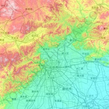
Name: Beijing topographic map, elevation, terrain.
Location: Beijing, China (39.17071 115.41721 41.05956 117.73712)
Average elevation: 1,493 ft
Minimum elevation: 0 ft
Maximum elevation: 7,543 ft
Other topographic maps
Click on a map to view its topography, its elevation and its terrain.
Chongqing
The central urban area of Chongqing, or Chongqing proper, is a city of unique features. Built on mountains and partially surrounded by the Yangtze and Jialing rivers, it is known as a "mountain city" and a "city on rivers". The night scene of the city is very illuminated, with millions of lights and their…
Average elevation: 1,043 ft
Hemu River
China > Xinjiang > Burqin County > Kom-Kanas Mongolian Ethnic Township
Average elevation: 5,682 ft
Gasherbrum II
China > Xinjiang > Taxkorgan Tajik Autonomous County > Dafdar
Gasherbrum II is located on the border of Gilgit–Baltistan, Pakistan, and Xinjiang, China. It is part of the Karakoram mountain range in the Himalayas, and located at the top of the Baltoro Glacier. With an elevation of 8,034 metres (26,358 ft) it is the third-highest member of the Gasherbrum group, behind…
Average elevation: 23,287 ft
Mount Wudang
China > Hubei > Danjiangkou City
Modern maps show the elevation of the highest of the peaks in the Wudang Shan "proper" as 1612 meters; however, the entire Wudangshan range has somewhat higher elevations elsewhere.
Average elevation: 3,845 ft
Kawagarbo
China > Tibet > Chamdo City
The Kawa Karpo has over 20 peaks with permanent snow cover, including six peaks over 6,000 m (19,700 ft). Topographic extremes are immense, with vertical relief ranging from less than 2,000 m along the Mekong River on the east to 6,740 m on the summit of Kawa Karpo within 10 km horizontal distance. Even…
Average elevation: 19,058 ft
Napahai Nature Reserve
China > Yunnan > Shangri-La > Jiantang > Chui Zongdala
Average elevation: 11,188 ft
Yarkand
China > Xinjiang > Yarkant County
Yarkant County, also Shache County, also transliterated from Uyghur as Yakan County, is a county in the Xinjiang Uyghur Autonomous Region, China, located on the southern rim of the Taklamakan Desert in the Tarim Basin. It is one of 11 counties administered under Kashgar Prefecture. The county, usually referred…
Average elevation: 4,026 ft