
Las Palmas de Gran Canaria topographic map
Interactive map
Click on the map to display elevation.
About this map
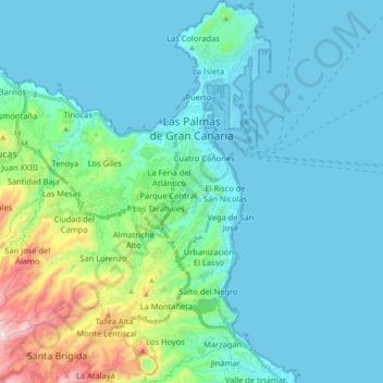
Name: Las Palmas de Gran Canaria topographic map, elevation, terrain.
Average elevation: 390 ft
Minimum elevation: -23 ft
Maximum elevation: 2,539 ft
Other topographic maps
Click on a map to view its topography, its elevation and its terrain.
Pyrenees
The Pyrenees (/ˈpɪrɪniːz/; Spanish: Pirineos [piɾiˈneos]; French: Pyrénées [piʁene] (listen); Catalan: Pirineu [piɾiˈnɛw]; Basque: Pirinioak [piɾini.o.ak]; Occitan: Pirenèus [piɾeˈnɛws]; Aragonese: Pirineus) is a mountain range straddling the border of France and Spain. It extends nearly 500…
Average elevation: 1,611 ft
Granada
Spain > Andalusia > Granada > Granada
Granada (/ɡrəˈnɑːdə/ grə-NAH-də, Spanish: , locally ) is the capital city of the province of Granada, in the autonomous community of Andalusia, Spain. Granada is located at the foot of the Sierra Nevada mountains, at the confluence of four rivers, the Darro, the Genil, the Monachil and the Beiro.…
Average elevation: 3,422 ft
Foz de Arbaiun / Arbaiungo arroila
Spain > Zangozerria / Comarca de Sangüesa > Romanzado/Erromantzatua
Average elevation: 2,215 ft
San Feliz de las Lavanderas
Spain > Castile and León > Quintana del Castillo
Average elevation: 3,825 ft
Santa Margarita
Spain > Andalusia > Campo de Gibraltar > La Línea de la Concepción
Average elevation: 207 ft
Port del Cantó
Spain > Catalonia > Alt Urgell > Montferrer i Castellbò
The Port del Cantó, or Coll del Cantó or Coll de la Pedra del Cantó, is a mountain pass at an altitude of 1,730 metres (5,680 ft) located at the border of the municipalities of Soriguera, in the comarca of Pallars Sobirà, and Montferrer i Castellbò in the comarca of Alt Urgell in Catalonia, Spain.
Average elevation: 5,768 ft
Sierra Nevada
Spain > Andalusia > Comarca de Guadix
Parts of the range have been included in the Sierra Nevada National Park. The range has also been declared a biosphere reserve. The Sierra Nevada Observatory, the Calar Alto Observatory, and the IRAM 30m telescope are located on the northern slopes at an elevation of 2,800 metres (9,200 ft).
Average elevation: 4,298 ft
Las Vegas
Spain > Navarre > Estellerriko Erribera / Ribera Estellesa > Lazagurría
Average elevation: 1,329 ft
Picos de Europa
The Picos de Europa ("Peaks of Europe", also the Picos) are a mountain range extending for about 20 km (12 mi), forming part of the Cantabrian Mountains in northern Spain. The range is situated in the Autonomous Communities of Asturias, Cantabria and Castile and León. The highest peak is Torre de Cerredo, at…
Average elevation: 7,513 ft
Unza
Spain > Autonomous Community of the Basque Country > Añanako kuadrilla/Cuadrilla de Añana > Zuhatzu Kuartango
Average elevation: 2,602 ft
Soil
Spain > Autonomous Community of the Basque Country > Montaña Alavesa/Arabako Mendialdea
Average elevation: 2,946 ft
Río de la Toba
Spain > Andalusia > Comarca de la Costa Granadina > Los Guájares
Average elevation: 1,037 ft
Plaça de Mahatma Gandhi
Spain > Catalonia > Baix Llobregat > Esplugues de Llobregat
Average elevation: 243 ft