Geolocate

Cranberry Island topographic map

Interactive map

Click on the map to display elevation.

About this map

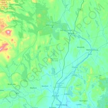
Name: Cranberry Island topographic map, elevation, terrain.

Location: Cranberry Island, Penobscot County, Maine, United States (45.16561 -68.99587 45.80561 -68.35587)

Average elevation: 472 ft

Minimum elevation: 121 ft

Maximum elevation: 2,900 ft

Maine trails, hiking, mountain biking, running and outdoor activities

Other topographic maps

Click on a map to view its topography, its elevation and its terrain.

Norway

United States > Maine > Oxford County

Average elevation: 591 ft

Cooper

United States > Maine > Washington County

Average elevation: 292 ft

New Portland

United States > Maine > Somerset County

Average elevation: 673 ft

Charleston

United States > Maine > Penobscot County

Average elevation: 394 ft

Pemaquid Pond

United States > Maine > Lincoln County > Damariscotta

Average elevation: 118 ft

Bowdoin

United States > Maine > Sagadahoc County

Average elevation: 253 ft

Eliot

United States > Maine > York County

Average elevation: 56 ft

Kittery

United States > Maine > York County

Average elevation: 26 ft

Medford

United States > Maine > Piscataquis County

Average elevation: 348 ft

Howland

United States > Maine > Penobscot County

Average elevation: 200 ft

Searsmont

United States > Maine > Waldo County

Average elevation: 322 ft

Brooks

United States > Maine > Waldo County

Average elevation: 446 ft

Deblois

United States > Maine > Washington County

Average elevation: 203 ft

Branch Brook

United States > Maine > York County > Newfield

Average elevation: 564 ft

Waite

United States > Maine > Washington County

Average elevation: 335 ft

Hills Beach

United States > Maine > York County > Biddeford

Average elevation: 10 ft

Mattawamkeag

United States > Maine > Penobscot County

Average elevation: 344 ft

Washington

United States > Maine > Knox County

Average elevation: 308 ft

Stoneham

United States > Maine > Oxford County

Average elevation: 876 ft

Kennebunkport

United States > Maine > York County

Average elevation: 39 ft

Madawaska

United States > Maine > Aroostook County

Average elevation: 728 ft

Saco Heath

United States > Maine > York County > Saco

Average elevation: 141 ft

Rangeley

United States > Maine > Rangeley

Average elevation: 1,801 ft

Whiting

United States > Maine > Washington County

Average elevation: 105 ft

Alfred

United States > Maine > York County > Alfred

Average elevation: 295 ft

Berwick

United States > Maine > York County > Berwick

Average elevation: 210 ft

Moscow

United States > Maine > Somerset County

Average elevation: 1,027 ft

Milford

United States > Maine > Penobscot County

Average elevation: 131 ft

T1 R13 WELS

United States > Maine > Piscataquis County

Average elevation: 1,385 ft

Sandy River

United States > Maine > Franklin County > Madrid Township

Average elevation: 1,073 ft

Swan's Island

United States > Maine > Hancock County

Average elevation: 7 ft

Ambejejus Lake

United States > Maine > Piscataquis County

Average elevation: 525 ft

Prospect

United States > Maine > Waldo County

Average elevation: 203 ft

Androscoggin County

United States > Maine

Average elevation: 404 ft

Tremont

United States > Maine > Hancock County

Average elevation: 66 ft

Verona Island

United States > Maine > Hancock County

The highest point is McCloud Mountain, at an elevation of 344 feet (105 m) above sea level.

Average elevation: 108 ft

Hallowell

United States > Maine > Kennebec County

Average elevation: 207 ft

Cumberland County

United States > Maine

Average elevation: 279 ft

Baxter State Park

United States > Maine > Piscataquis County

After assuming the Maine Senate presidency during the state's 80th legislative session, Percival Baxter appointed his brother Rupert, a Senator from Sagadahoc County, to the Committee on State Lands and Forest Preservation, which would be considering legislation that would create a state park at Katahdin.…

Average elevation: 1,237 ft

Mariaville

United States > Maine > Hancock County

Average elevation: 259 ft

Dallas Plantation

United States > Maine > Franklin County

Average elevation: 1,965 ft

Great Pond

United States > Maine > Hancock County

Average elevation: 446 ft

Aurora

United States > Maine > Hancock County

Average elevation: 374 ft

Limerick

United States > Maine > York County

Average elevation: 499 ft

Waltham

United States > Maine > Hancock County

Average elevation: 180 ft

Sorrento

United States > Maine > Hancock County

Average elevation: 30 ft

Eddington

United States > Maine > Penobscot County

Average elevation: 167 ft

Osborn

United States > Maine > Hancock County

Average elevation: 315 ft

Amherst

United States > Maine > Hancock County

Average elevation: 387 ft

Chesterville

United States > Maine > Franklin County

Average elevation: 512 ft

Eastbrook

United States > Maine > Hancock County

Average elevation: 246 ft

Marshfield

United States > Maine > Washington County

Average elevation: 167 ft

Davis Island

United States > Maine > Lincoln County > Edgecomb

Average elevation: 43 ft

Frenchboro

United States > Maine > Hancock County

Average elevation: 7 ft

Fairmont Park

United States > Maine > Penobscot County > Bangor

Average elevation: 148 ft

Camden

United States > Maine > Knox County

According to the U.S. Census Bureau, the town has a total area of 26.65 square miles (69.02 km2), of which, 18.24 square miles (47.24 km2) of it is land and 8.41 square miles (21.78 km2) is water. Drained by the Megunticook River, Camden is located beside Penobscot Bay and the Gulf of Maine, part of the…

Average elevation: 207 ft

Dixmont

United States > Maine > Penobscot County

Dixmont was on the main stage-coach route between Bangor and Augusta, and given that it had the highest elevation along that road, it became a natural rest-stop for tired horses. Wrote William Lloyd Garrison in 1832: "The Dixmont Hills are famous and formidable along this route . . . they are piled upon my…

Average elevation: 482 ft

Avon

United States > Maine > Franklin County

According to the United States Census Bureau, the town has a total area of 41.65 square miles (107.87 km2), of which 41.39 square miles (107.20 km2) is land and 0.26 square miles (0.67 km2) is water. Avon is drained by the Sandy River, a tributary of the Kennebec River. Mount Blue, elevation 3,192 feet (973…

Average elevation: 961 ft

Manchester

United States > Maine > Kennebec County

Average elevation: 276 ft

Blue Hill

United States > Maine > Hancock County

According to the United States Census Bureau, the town has a total area of 86.57 square miles (224.22 km2), of which 62.48 square miles (161.82 km2) is land and 24.09 square miles (62.39 km2) is water. Located on Blue Hill Bay, the town is drained by Mill Brook. Blue Hill, elevation 940 feet (287 meters), is…

Average elevation: 125 ft

Sebago

United States > Maine > Cumberland County

According to the United States Census Bureau, the town has a total area of 48.93 square miles (126.73 km2), of which 32.76 square miles (84.85 km2) is land and 16.17 square miles (41.88 km2) is water. Situated beside Sebago Lake, Sebago is drained by the Northwest River and Mill Brook. Douglas Mountain has an…

Average elevation: 525 ft

Oquossoc

United States > Maine > Franklin County > Rangeley

Average elevation: 1,601 ft

T3 R10 WELS

United States > Maine > Piscataquis County

Average elevation: 1,795 ft

Roxbury

United States > Maine > Oxford County

Average elevation: 1,243 ft

Coplin Plantation

United States > Maine > Franklin County

Average elevation: 1,624 ft

West Gardiner

United States > Maine > Kennebec County

Average elevation: 217 ft

Lincoln

United States > Maine > Penobscot County

Average elevation: 312 ft

Woolwich

United States > Maine > Sagadahoc County

Average elevation: 69 ft

Frye Island

United States > Maine > Cumberland County

Average elevation: 279 ft

Flat Island

United States > Maine > Hancock County > Deer Isle

Average elevation: 26 ft

Wales

United States > Maine > Androscoggin County

Average elevation: 325 ft

Trenton

United States > Maine > Hancock County

Average elevation: 62 ft

Eustis

United States > Maine > Franklin County

Average elevation: 1,355 ft

Carthage

United States > Maine > Franklin County

Average elevation: 994 ft

Eagle Lake

United States > Maine > Aroostook County

Average elevation: 856 ft

Weston

United States > Maine > Aroostook County

Average elevation: 492 ft

Island Falls

United States > Maine > Aroostook County

Average elevation: 522 ft

Nobleboro

United States > Maine > Lincoln County

Average elevation: 131 ft

Lincolnville

United States > Maine > Waldo County

Average elevation: 197 ft

Ashland

United States > Maine > County

Average elevation: 689 ft

Perham

United States > Maine > Aroostook County

Average elevation: 741 ft

Thorndike

United States > Maine > Waldo County

Average elevation: 400 ft

West Paris

United States > Maine > Oxford County

Average elevation: 768 ft