
Jack Creek topographic map
Interactive map
Click on the map to display elevation.
About this map
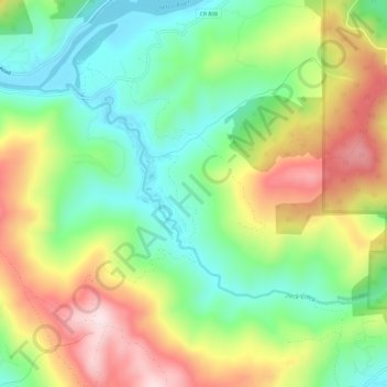
Name: Jack Creek topographic map, elevation, terrain.
Location: Jack Creek, Curry County, Oregon, United States (42.03860 -124.22750 42.06394 -124.16718)
Average elevation: 558 ft
Minimum elevation: 3 ft
Maximum elevation: 1,362 ft
Oregon trails, hiking, mountain biking, running and outdoor activities
Other topographic maps
Click on a map to view its topography, its elevation and its terrain.
Willamette River
United States > Oregon > Polk County
The Willamette River drains a region of 11,478 square miles (29,730 km2), which is 12 percent of the total area of Oregon. Bounded by the Coast Range to the west and the Cascade Range to the east, the river basin is about 180 miles (290 km) long and 100 miles (160 km) wide. Elevations within the watershed…
Average elevation: 236 ft
Newberg
United States > Oregon > Yamhill County
According to the United States Census Bureau, the city has a total area of 5.81 square miles (15.05 km2), all of it land. It averages 176 feet (54 m) in elevation.
Average elevation: 200 ft
Mount Bachelor
United States > Oregon > Deschutes County
Mount Bachelor lies in the Cascade Range, within Deschutes County, in the U.S. state of Oregon. It is located south of the Three Sisters complex volcano, and reaches an elevation of 9,068 feet (2,764 m). It rises 3,500 feet (1,100 m) above its base, with a proximal relief of 2,674 feet (815 m). The volcano has…
Average elevation: 7,628 ft
Cave Junction
United States > Oregon > Josephine County
Cave Junction is located on U.S. Route 199 at its junction with Oregon Route 46. It is about 30 miles or 48 kilometres southwest of Grants Pass, Oregon and 53 miles or 85 kilometres northeast of Crescent City, California. The city lies in the Illinois Valley, on the northwest slope of the Siskiyou Range, at an…
Average elevation: 1,345 ft
Multnomah Falls
United States > Oregon > Multnomah County
The falls drops in two major steps, split into an upper falls of 542 feet (165 m) and a lower falls of 69 feet (21 m), with a gradual 9 foot (3 m) drop in elevation between the two, so the total height of the waterfall is conventionally given as 620 feet (189 m). The two drops are due to a zone of more easily…
Average elevation: 886 ft
Powell Butte
United States > Oregon > Multnomah County > Portland
Powell Butte is located in Multnomah County in the U.S. state of Oregon. According to the U.S. National Geodetic Survey, the butte reaches an elevation of 614 feet (187 m), while the Geographic Names Information System lists the mountain's elevation at 627 feet (191 m). J.E. Allen, an emeritus professor of…
Average elevation: 344 ft
Mount Mazama
United States > Oregon > Klamath County
Mount Mazama (Tum-sum-ne in the Native American language Klamath) is a complex volcano in the western U.S. state of Oregon, in a segment of the Cascade Volcanic Arc and Cascade Range. The volcano is in Klamath County, in the southern Cascades, 60 miles (97 km) north of the Oregon–California border. Its…
Average elevation: 6,168 ft
Pittsburg
United States > Oregon > Columbia County
Pittsburg is an unincorporated community in Columbia County, Oregon, United States. Pittsburg is located on the Nehalem River near its confluence with the East Fork Nehalem River. The Scappoose-Vernonia road and the St. Helens-Pittsburg road join Oregon Route 47 near Pittsburg. Pittsburg's elevation is 584…
Average elevation: 764 ft