
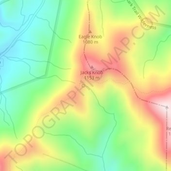
Chattahoochee Source Spring topographic map
Interactive map
Click on the map to display elevation.
About this map
Name: Chattahoochee Source Spring topographic map, elevation, terrain.
Average elevation: 3,104 ft
Minimum elevation: 2,431 ft
Maximum elevation: 3,960 ft
Georgia trails, hiking, mountain biking, running and outdoor activities
Other topographic maps
Click on a map to view its topography, its elevation and its terrain.
Brunswick
United States > Georgia > Glynn County
The city is the lowest in the U.S. state of Georgia, with an elevation of only 10 to 14 feet (3.0 to 4.3 m) above sea level. According to the U.S. Census Bureau, Brunswick's land area is 32.4 square miles (83.8 km2). Its total area is 42.4 square miles (109.8 km2); 10.0 square miles (26.0 km2) of this is water.
Average elevation: 7 ft
Skidaway Island State Park
United States > Georgia > Chatham County > Skidaway Island
Average elevation: 16 ft
Panola Mountain State Park
United States > Georgia > Rockdale County > Stockbridge
Average elevation: 778 ft
Rabun Gap Nacoochee School Lake Dam
United States > Georgia > Rabun County
Average elevation: 2,201 ft
Lake Hartwell
United States > Georgia > Stephens County > Anderson
Lake Hartwell is a man-made reservoir bordering Georgia and South Carolina and encompassing parts of the Savannah, Tugaloo, and Seneca rivers. Lake Hartwell is one of the Southeastern United States' largest recreation lakes. The lake was created by the construction of the Hartwell Dam, completed in 1962 and…
Average elevation: 879 ft
Chattahoochee River National Recreation Area
United States > Georgia > Forsyth County > Atlanta
Average elevation: 1,037 ft
Tiger
United States > Georgia > Rabun County
Tiger lies in the extreme northeastern part of the state, just a few miles west of the Georgia-South Carolina border, and a few miles south of the Georgia-North Carolina border. The town's elevation is 1,962 feet (598 m), with several wooded hilltops reaching elevations of 2,100 to 2,200 feet. The town sits at…
Average elevation: 1,995 ft
Lake Lanier
United States > Georgia > Forsyth County > Cumming
According to the Army Corps of Engineers, the Dam has a current installed capacity of 126 megawatts and a hydraulic head of 136 feet. Other pertinent information on the reservoir, power plant, etc. can be found on the Mobile District Corps of Engineers web site. Also, historic operational information on lake…
Average elevation: 1,152 ft
Alto
United States > Georgia > Banks County
Alto was so named on account of its (relatively) lofty elevation (1,394 feet above mean sea level). A post office called Alto has been in operation since 1879. The town incorporated in 1895.
Average elevation: 1,335 ft
Nicholls
United States > Georgia > Coffee County
Nicholls, Georgia is in the Wiregrass Region of the United States and inherits its topography and ecological diversity.
Average elevation: 177 ft