Geolocate

Gear up for your next adventure:

As an Amazon Associate, this site earns from qualifying purchases at no extra cost to you.

👉 Easily get elevation data in JSON, GeoTIFF and KML formats using Elevation API
Thank you for supporting this site ❤️
Make a donation

Wake County topographic map

Click on the map to display elevation.

Gear up for your next adventure:

As an Amazon Associate, this site earns from qualifying purchases at no extra cost to you.

Gear up for your next adventure:

As an Amazon Associate, this site earns from qualifying purchases at no extra cost to you.

👉 Easily get elevation data in JSON, GeoTIFF and KML formats using Elevation API
Thank you for supporting this site ❤️
Make a donation

Wake County

Wake County is located in the northeast central region of North Carolina, where the North American Piedmont and Atlantic Coastal Plain regions meet. This area is known as the "fall line" because it marks the elevation inland at which waterfalls begin to appear in creeks and rivers. As a result, most of Wake County features gently rolling hills that slope eastward toward the state's flat coastal plain. Its central Piedmont location situates the county about three hours west of Atlantic Beach by car and four hours east of the Great Smoky Mountains.

Wikipedia (CC-BY-SA 3.0)

Gear up for your next adventure:

As an Amazon Associate, this site earns from qualifying purchases at no extra cost to you.

👉 Easily get elevation data in JSON, GeoTIFF and KML formats using Elevation API
Thank you for supporting this site ❤️
Make a donation

About this map

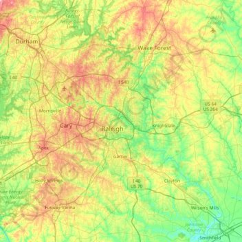
Name: Wake County topographic map, elevation, terrain.

Location: Wake County, North Carolina, United States (35.51946 -78.99507 36.07654 -78.25453)

Average elevation: 315 ft

Minimum elevation: 98 ft

Maximum elevation: 715 ft

North Carolina trails, hiking, mountain biking, running and outdoor activities

Gear up for your next adventure:

As an Amazon Associate, this site earns from qualifying purchases at no extra cost to you.

👉 Easily get elevation data in JSON, GeoTIFF and KML formats using Elevation API
Thank you for supporting this site ❤️
Make a donation

Other topographic maps

Click on a map to view its topography, its elevation and its terrain.

Appalachian Mountains

United States > North Carolina > Yancey County

The Appalachian Mountains (French: Appalaches), often called the Appalachians, are a system of mountains in eastern to northeastern North America. The Appalachians first formed roughly 480 million years ago during the Ordovician Period. They once reached elevations similar to those of the Alps and the Rocky…

Average elevation: 4,800 ft

Sapphire

United States > North Carolina > Transylvania County

Average elevation: 3,271 ft

Appalachian Mountains

United States > North Carolina > Yancey County

The Appalachian Mountains (French: Appalaches), often called the Appalachians, are a system of mountains in eastern to northeastern North America. The Appalachians first formed roughly 480 million years ago during the Ordovician Period. They once reached elevations similar to those of the Alps and the Rocky…

Average elevation: 4,800 ft

Gear up for your next adventure:

As an Amazon Associate, this site earns from qualifying purchases at no extra cost to you.

Thank you for supporting this site ❤️
Make a donation

Cane Creek

United States > North Carolina > Union County

Average elevation: 581 ft

Hubert

United States > North Carolina > Onslow County

Average elevation: 33 ft

Possumtrot

United States > North Carolina > Yancey County

Average elevation: 2,972 ft

Gear up for your next adventure:

As an Amazon Associate, this site earns from qualifying purchases at no extra cost to you.

Thank you for supporting this site ❤️
Make a donation

Highlands

United States > North Carolina > Macon County > Highlands

Highlands was founded in 1875 after its two founders, Samuel Truman Kelsey and Clinton Carter Hutchinson, drew lines from Chicago to Savannah and from New Orleans to New York City. They felt that the place where these lines met would eventually become a great trading center and commercial crossroads. Highlands…

Average elevation: 3,576 ft

Elliott

United States > North Carolina > Sampson County

Average elevation: 115 ft

Gear up for your next adventure:

As an Amazon Associate, this site earns from qualifying purchases at no extra cost to you.

Thank you for supporting this site ❤️
Make a donation

Porter

United States > North Carolina > Beaufort County

Average elevation: 23 ft

Mount Mitchell

United States > North Carolina > Yancey County

Mount Mitchell, known in Cherokee as Attakulla, is the highest peak of the Appalachian Mountains and the highest peak in mainland eastern North America. It is located near Burnsville in Yancey County, North Carolina in the Black Mountain subrange of the Appalachians about 19 miles (31 km) northeast of…

Average elevation: 5,719 ft

Pelham

United States > North Carolina > Caswell County

Average elevation: 650 ft

Candler

United States > North Carolina > Buncombe County

Average elevation: 2,195 ft

Gear up for your next adventure:

As an Amazon Associate, this site earns from qualifying purchases at no extra cost to you.

Thank you for supporting this site ❤️
Make a donation

Lawsonville

United States > North Carolina > Stokes County

Average elevation: 1,076 ft

Bynum

United States > North Carolina > Chatham County

Average elevation: 407 ft

Rover

United States > North Carolina > Beaufort County

Average elevation: 36 ft

Gear up for your next adventure:

As an Amazon Associate, this site earns from qualifying purchases at no extra cost to you.

Thank you for supporting this site ❤️
Make a donation

Yorkwood

United States > North Carolina > Gaston County

Average elevation: 738 ft

Jersey

United States > North Carolina > Davidson County

Average elevation: 663 ft

Honeycutt

United States > North Carolina > Mitchell County

Average elevation: 2,799 ft

Fox Run

United States > North Carolina > Nash County > Rocky Mount

Average elevation: 125 ft

Gear up for your next adventure:

As an Amazon Associate, this site earns from qualifying purchases at no extra cost to you.

Thank you for supporting this site ❤️
Make a donation

Westmoore

United States > North Carolina > Moore County

Average elevation: 535 ft

Delta

United States > North Carolina > Stokes County

Average elevation: 1,033 ft

Sandy Ridge

United States > North Carolina > Stokes County

Average elevation: 1,056 ft

Deep Creek

United States > North Carolina > Swain County > Bryson City

Average elevation: 1,998 ft

Gear up for your next adventure:

As an Amazon Associate, this site earns from qualifying purchases at no extra cost to you.

Thank you for supporting this site ❤️
Make a donation

Bunnlevel

United States > North Carolina > Harnett County

Average elevation: 144 ft

Deep Creek Gap

United States > North Carolina > Swain County

Average elevation: 3,392 ft

Glencoe

United States > North Carolina > Alamance County

Average elevation: 604 ft

Ocracoke

United States > North Carolina > Hyde County > Ocracoke

Average elevation: 3 ft

Gear up for your next adventure:

As an Amazon Associate, this site earns from qualifying purchases at no extra cost to you.

Thank you for supporting this site ❤️
Make a donation

Newton Bald

United States > North Carolina > Swain County

Average elevation: 4,311 ft

Colington

United States > North Carolina > Dare County

Average elevation: 3 ft

Bly Gap

United States > North Carolina > Clay County

Average elevation: 3,478 ft

Tyre Knob

United States > North Carolina > Graham County

Average elevation: 2,710 ft

Gear up for your next adventure:

As an Amazon Associate, this site earns from qualifying purchases at no extra cost to you.

Thank you for supporting this site ❤️
Make a donation

Crumpler

United States > North Carolina > Ashe County

Average elevation: 2,749 ft

Buffalo

United States > North Carolina > Stokes County

Average elevation: 994 ft

North Cove

United States > North Carolina > McDowell County

Average elevation: 1,850 ft

Gear up for your next adventure:

As an Amazon Associate, this site earns from qualifying purchases at no extra cost to you.

Thank you for supporting this site ❤️
Make a donation

Kyle

United States > North Carolina > Macon County

Average elevation: 3,524 ft

Lakewood

United States > North Carolina > Guilford County

Average elevation: 774 ft

Gear up for your next adventure:

As an Amazon Associate, this site earns from qualifying purchases at no extra cost to you.

Thank you for supporting this site ❤️
Make a donation

Topton

United States > North Carolina > Cherokee County

Average elevation: 3,215 ft

Qualla

United States > North Carolina > Jackson County

Average elevation: 2,060 ft

Warne

United States > North Carolina > Clay County

Average elevation: 1,864 ft

Gear up for your next adventure:

As an Amazon Associate, this site earns from qualifying purchases at no extra cost to you.

Thank you for supporting this site ❤️
Make a donation

Lake Worth

United States > North Carolina > Dare County

Average elevation: 3 ft

Buxton

United States > North Carolina > Dare County

Average elevation: 7 ft

Glendale Springs

United States > North Carolina > Ashe County

Average elevation: 2,923 ft

Apple Grove

United States > North Carolina > Ashe County

Average elevation: 3,284 ft

Gear up for your next adventure:

As an Amazon Associate, this site earns from qualifying purchases at no extra cost to you.

Thank you for supporting this site ❤️
Make a donation

Edgemont

United States > North Carolina > Caldwell County

Average elevation: 1,929 ft

Traphill

United States > North Carolina > Wilkes County

Average elevation: 1,352 ft

Bishop

United States > North Carolina > Brunswick County

Average elevation: 26 ft

Gear up for your next adventure:

As an Amazon Associate, this site earns from qualifying purchases at no extra cost to you.

Thank you for supporting this site ❤️
Make a donation

Lawsonville

United States > North Carolina > Stokes County

Average elevation: 1,076 ft

Stone Mountain

United States > North Carolina > Wilkes County

Stone Mountain is the centerpiece of Stone Mountain State Park in North Carolina. It is a dome of exposed granite (specifically a quartz diorite to granodiorite) of Devonian age, which has intruded into the gneiss of the Precambrian Alligator Back Formation. It rises sharply over 600 feet (183 m) above the…

Average elevation: 1,860 ft

Rich Mountain

United States > North Carolina > Watauga County

Rich Mountain is a mountain located in the North Carolina High Country, roughly 3 miles (4.8 km) northwest of the town of Boone. Its elevation reaches 4,748 feet (1,447 m).

Average elevation: 3,983 ft

Gear up for your next adventure:

As an Amazon Associate, this site earns from qualifying purchases at no extra cost to you.

Thank you for supporting this site ❤️
Make a donation

Marlboro

United States > North Carolina > Pender County

Average elevation: 30 ft

Little Scaly

United States > North Carolina > Macon County

Average elevation: 3,573 ft

Linville

United States > North Carolina > Avery County

Average elevation: 3,885 ft

Ennice

United States > North Carolina > Alleghany County

Average elevation: 2,605 ft

Gear up for your next adventure:

As an Amazon Associate, this site earns from qualifying purchases at no extra cost to you.

Thank you for supporting this site ❤️
Make a donation

Sheep Cliff

United States > North Carolina > Jackson County

Average elevation: 3,898 ft

Hayes

United States > North Carolina > Durham County > Durham

Average elevation: 377 ft

Gear up for your next adventure:

As an Amazon Associate, this site earns from qualifying purchases at no extra cost to you.

Thank you for supporting this site ❤️
Make a donation

Cove

United States > North Carolina > Haywood County

Average elevation: 3,035 ft

Cullowhee

United States > North Carolina > Jackson County

Average elevation: 2,270 ft

Waxhaw

United States > North Carolina > Union County

Average elevation: 614 ft

Gear up for your next adventure:

As an Amazon Associate, this site earns from qualifying purchases at no extra cost to you.

Thank you for supporting this site ❤️
Make a donation

Ocean Dunes

United States > North Carolina > Dare County > Duck

Average elevation: 3 ft

Low Gap

United States > North Carolina > Yancey County

Average elevation: 3,261 ft

Cowee

United States > North Carolina > Macon County

Average elevation: 2,119 ft

Gear up for your next adventure:

As an Amazon Associate, this site earns from qualifying purchases at no extra cost to you.

Thank you for supporting this site ❤️
Make a donation

Peachtree

United States > North Carolina > Cherokee County

Average elevation: 1,755 ft

Nebo

United States > North Carolina > McDowell County

Average elevation: 1,293 ft

Gear up for your next adventure:

As an Amazon Associate, this site earns from qualifying purchases at no extra cost to you.

Thank you for supporting this site ❤️
Make a donation